The Daintree National Park is located in Far North Queensland, Australia, 1,757 km (1,092 mi) northwest of Brisbane and 100 km (62 mi) northwest of Cairns. It was founded in 1981 and is part of the Wet Tropics of Queensland. In 1988, it became a World Heritage Site. The park consists of two sections—Mossman Gorge and Cape Tribulation, with a settled agricultural area between them which includes the towns of Mossman and Daintree Village.

Cairns is a city in the Cairns Region, Queensland, Australia, on the tropical north east coast of Far North Queensland. In the 2021 census, Cairns had a population of 153,181 people.

Cape Tribulation is a headland and coastal locality in the Shire of Douglas in northern Queensland, Australia. In the 2021 census, Cape Tribulation had a population of 123 people.

Far North Queensland (FNQ) is the northernmost part of the Australian state of Queensland. Its largest city is Cairns and it is dominated geographically by Cape York Peninsula, which stretches north to the Torres Strait, and west to the Gulf Country. The waters of Torres Strait include the only international border in the area contiguous with the Australian mainland, between Australia and Papua New Guinea.

Mossman is a rural town and locality in the Shire of Douglas, Queensland, Australia. It is the administrative centre for the Douglas Shire Council In the 2021 census, the locality of Mossman had a population of 1,935 people.
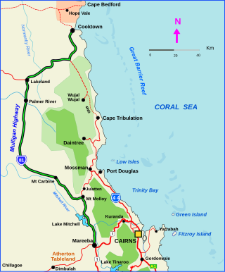
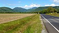
The Mulligan Highway is a state highway in Queensland, Australia. It runs for approximately 266 km between Mareeba and Cooktown, on the east coast of Cape York Peninsula where it terminates. It is signed as State Route 81 from Mareeba to Lakeland and State Route 40 from Lakeland to Cooktown. It is a state-controlled regional road.

Smithfield is a suburb of Cairns in the Cairns Region, Queensland, Australia. In the 2021 census, Smithfield had a population of 6,664 people.
Southedge-Wangetti Road Corridor is a 32-kilometre-long (20 mi) stretch of road in Far North Queensland. It links the Captain Cook Highway at Wangetti on the coast just north of Cairns, to the Mulligan Highway at Southedge, just south of Mount Molloy. In November 1983 George Quaid wanted to legally build the road corridor with the approval of the Queensland Government, which was granted. In April 1988 the Australian Government made a regulation under the World Heritage Properties Conservation Act 1983 to prevent the road opening. However, the road was completed in early 1989 through some rainforest areas that were later declared Wet Tropics World Heritage Area in late 1989.

Palm Cove is a suburb of Cairns in the Cairns Region, Queensland, Australia. In the 2021 census, Palm Cove had a population of 2,450 people.

Aeroglen is a coastal suburb of Cairns in the Cairns Region, Queensland, Australia. It is approximately 5 kilometers north of the Cairns City centre. In the 2021 census, Aeroglen had a population of 405 people.
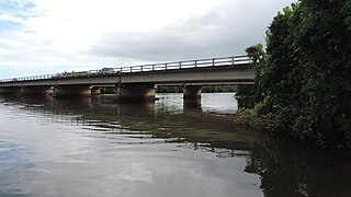
The William Walter Mason Memorial Bridge is a road bridge that carries the Captain Cook Highway across the Barron River at the boundary of four suburbs in Cairns in the Cairns Region, Queensland, Australia.

Kewarra Beach is a coastal suburb of Cairns in the Cairns Region, Queensland, Australia. In the 2021 census, Kewarra Beach had a population of 6,133 people.

Kuranda National Park is a national park in Far North Queensland, Australia. Like many national parks in the area it belongs to the Wet Tropics World Heritage Area. The park protects an important wildlife corridor in which rainforest and open eucalypt forest predominate. Walking, mountain biking and four-wheel driving are popular recreational activities.
The Cairns Western Arterial Road is a numbered state route in the Cairns Region of Queensland, Australia. The road provides a primary access route across the Brinsmead Gap for suburbs west of the Whitfield Range, and is one of two major crossings over the Barron River. In 2007, it was estimated that 24,000 vehicles per day used the road.
Cassowary is a rural locality in the Shire of Douglas, Queensland, Australia. In the 2021 census, Cassowary had a population of 119 people.

Craiglie is a coastal rural locality in the Shire of Douglas, Queensland, Australia. In the 2021 census, Craiglie had a population of 1,062 people.

Killaloe is a coastal rural locality in the Shire of Douglas, Queensland, Australia. In the 2021 census, Killaloe had a population of 124 people.

Shannonvale is a rural locality in the Shire of Douglas, Queensland, Australia. Most of the locality forms part of the UNESCO World Heritage-listed Wet Tropics of Queensland, In the 2021 census, Shannonvale had a population of 194 people.

Barron is a suburb of Cairns in the Cairns Region, Queensland, Australia. In the 2021 census, Barron had a population of 68 people.
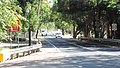
Cairns road network is a group of roads that provide access to the urban areas of Cairns in Queensland, Australia, and enable travel between the communities. Most of the roads retain their original road or street names, and are not well known by their official names.