Related Research Articles

Mount Isa is a city in the Gulf Country region of Queensland, Australia. It came into existence because of the vast mineral deposits found in the area. Mount Isa Mines (MIM) is one of the most productive single mines in world history, based on combined production of lead, silver, copper and zinc.

Cloncurry is a rural town and locality in the Shire of Cloncurry, Queensland, Australia. In the 2021 census the locality of Cloncurry had a population of 3,167 people.
MacAir Airlines Pty Ltd was a regional airline based in Townsville, Queensland, Australia. It operated scheduled passenger services throughout Queensland from major regional locations, as well as regular and ad hoc charters for the minerals industry in Queensland. Its main operations base was Townsville Airport, with hubs at Cairns, Brisbane and Mount Isa.

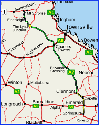
The Flinders Highway is a highway that crosses Queensland east to west, from Townsville on the Pacific coast to Cloncurry. The road continues as the Barkly Highway from Cloncurry to the Northern Territory border at Camooweal and beyond. The Flinders Highway passes a number of small outback towns and typical outback landscape predominates towards the inland. It was known as National Route 78 before Queensland began to convert to the alphanumeric system being adopted in Australia and is now designated as A6. The highway is also known as Overlanders Way. Its entire length is part of the National Land Transport Network.
The Gregory Highway is a state highway in Queensland, Australia that serves the major coal-mining centres of Central Queensland. The highway was named after Augustus Gregory, an early explorer.

The Barkly Highway is a national highway of both Queensland and the Northern Territory in Australia. It is the only sealed road between Queensland and the Northern Territory.

Landsborough Highway is a highway in western Queensland, Australia, running in the northwest–southeast direction from Morven to Cloncurry. The Landsborough Highway runs through vast tracts of land that was once occupied by William Landsborough, an Australian explorer of the 19th century. It is also the central part of the tourist route known as the Matilda Way after the popular Australian song Waltzing Matilda, which extends from Bourke in central northern New South Wales to Karumba on the Gulf of Carpentaria.
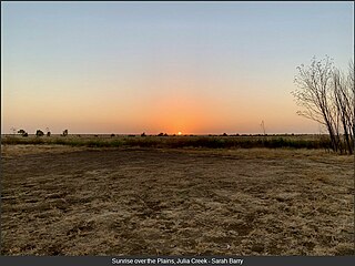
Julia Creek is an outback town and locality in the Shire of Mckinlay, Queensland, Australia. In the 2016 census, the locality of Julia Creek had a population of 511 people.

The Kennedy Highway is a highway in northern Queensland, Australia. It runs as National Route 1 for approximately 243 km from Smithfield, on the northern outskirts of Cairns, to the Gulf Developmental Road in the vicinity of Forty Mile Scrub and Undara Volcanic national parks. South of this junction, the road continues as the Kennedy Developmental Road to Boulia about 936 kilometres away, via Hughenden. West of the junction, National Route 1 continues as the Gulf Developmental Road to Normanton.

The Roman Catholic Diocese of Townsville is a suffragan Latin Rite diocese of the Archdiocese of Brisbane, erected in 1930, covering North Queensland, Australia. It was excised from the Diocese of Rockhampton, which had previously covered all of North Queensland.
The electoral district of Flinders was an electoral district of the Legislative Assembly in the Australian state of Queensland.
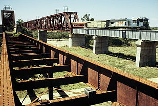
The Great Northern Railway is a 1067 mm gauge railway line in Queensland, Australia. The line stretches nearly 1,000 kilometres linking the port city of Townsville, Australia to the mining town of Mount Isa in north-west Queensland. Along with a passenger service called the Inlander, it is a major freight route connecting the Mount Isa Mines to the Port of Townsville. In 2010, the line moved 5.8 million tonnes of cargo, and this is expected to increase significantly in coming years.

The Hughenden-Winton railway line was a railway line in Queensland, Australia, branching from the Mt Isa line at Hughenden and connecting to the Central West line at Winton.
Nelia is an outback town in the locality of Julia Creek in the Shire of Mckinlay, Queensland, Australia.

State Strategic Touring Routes (SSTR) are road routes in Queensland, Australia, which have been identified as significant to motoring tourists. These are the primary routes used by tourists as they provide the connections between popular tourist locations, and consequently have high volumes of tourist traffic. Standardised road signage is used to identify the route itself, with "Welcome to" signage at towns and districts of interest to tourists, as well as "turn off" signage to natural attractions.
The Great Inland Way is an Australian road route from Sydney, New South Wales to Cairns in Queensland. It has been designated by the Queensland Government as a State Strategic Touring Route.
The Matilda Way is an Australian road route from Bourke, New South Wales to Karumba in Queensland. It has been designated by the Queensland Government as a State Strategic Touring Route.
The Pacific Coast Way is an Australian road route from Sydney, New South Wales to Cairns in Queensland. It has been designated by the Queensland Government as a State Strategic Touring Route.
Cloncurry–Dajarra Road is a continuous 169 kilometres (105 mi) road route in the Cloncurry local government area of Queensland, Australia. It is a state-controlled district road rated as a local road of regional significance (LRRS). It is a north-east to south-west link between the Barkly Highway and the Diamantina Developmental Road, servicing a number of cattle grazing and production areas in northern Queensland.
Roads of Strategic Importance in Queensland is a list of roads in Queensland, Australia, that are the subject of one or more road improvement projects under the Roads of Strategic Importance (ROSI) initiative of the Australian Government. The purposes of this document are to:
References
- ↑ "Driving Experiences (State Strategic Touring Routes and Tourist Drives)" (PDF). Department of Transport and Main Roads. Queensland Government. February 2016. Archived (PDF) from the original on 27 May 2017. Retrieved 17 July 2017. Licensed CC BY 3.0 AU.
- ↑ "Overlanders Way". Outback Queensland. Retrieved 19 July 2017.