Redcliffe Peninsula road network

Last updated

Redcliffe Peninsula road network is a group of roads that provide access to the Redcliffe Peninsula in Queensland, Australia, and enable travel between the contained communities. The area serviced by the network includes the localities of Clontarf, Kippa-Ring, Margate, Newport, Redcliffe, Rothwell, Scarborough and Woody Point. [1]

Contents

The area hosts a substantial residential community plus many tourism accommodation venues. [2] The estimated population for the area described as the Former Redcliffe Peninsula District as at 30 June 2021 was 64,366. [3]

Roads in the network

The network [4] consists of the following state-controlled roads:

A number of local roads that also link the localities are not included in this article.

Brighton–Redcliffe Road

Brighton–Redcliffe Road

Australian state route 27.svg

LocationDeagon Deviation and Beaconsfield Terrace, Brighton to Klingner Road, Redcliffe
Length9.8 km (6.1 mi)
Route number 27

This road has the following components:

Brighton–Redcliffe Road is a state-controlled road (number 122), part regional and part district, rated as a local road of regional significance (LRRS). [5] [6] It carries traffic from Brighton, via Clontarf, Woody Point and Margate, to Redcliffe, a distance of 9.8 kilometres (6.1 mi). All of this road is part of State Route 27. [7]

The road starts at the intersection of the Deagon Deviation (State Route 26) and Beaconsfield Terrace (State Route 27) in Brighton. It runs north-east across Bramble Bay, over the Houghton Highway (northbound) and the Ted Smout Memorial Bridge (southbound), to Clontarf. It passes the exit to Clontarf–Anzac Avenue Road (Elizabeth Avenue) and continues north-east and east as Hornibrook Esplanade to Woody Point, where the name changes to Oxley Avenue as it turns north. [7]

Continuing north the road passes through Margate and enters Redcliffe, crossing Redcliffe Road (Anzac Avenue) and reaching Klingner Road, where it ends. Oxley Avenue continues north as State Route 27. Each bridge carries three lanes of traffic, and most of the road is a divided four lane carriageway. [7]

Oxley Avenue safety works

A project to provide safety works at five intersections in Redcliffe, three of which are on Oxley Avenue, was underway at March 2022. [8]

Major intersections (Brighton–Redcliffe Road)

All distances are from Google Maps. [7] The road commences in the Brisbane local government area (LGA) but all other intersections are within the Moreton Bay LGA.

LocationkmmiDestinationsNotes
Brighton 00.0Australian state route 26.svg Deagon Deviation – southwest – Deagon
Australian state route 27.svg Beaconsfield Terrace – south – Sandgate
Southern end of Brighton–Redcliffe Road (State Route 27).
The road starts in the Brisbane LGA and crosses Bramble Bay to the Moreton Bay LGA. It uses the Houghton Highway northbound and the Ted Smout Memorial Bridge southbound.
Clontarf 3.11.9Australian state route 26.svg Clontarf–Anzac Avenue Road – north (as Elizabeth Avenue) – Kippa-Ring Road continues north east as Hornibrook Esplanade.
Woody Point 5.83.6Oxley Avenue – south – Woody PointRoad continues north as Oxley Avenue (State Route 27)
Redcliffe 9.05.6Australian state route 71.svg Redcliffe Road (Anzac Avenue) – west – Kippa-Ring
– east – Redcliffe
Road continues north.
9.86.1Klingner Road – west – Kippa-Ring
– east – Redcliffe
Northern end of Brighton–Redcliffe Road (State Route 27) Oxley Avenue continues north as State Route 27.
1.000 mi = 1.609 km; 1.000 km = 0.621 mi
  •        Route transition

Clontarf–Anzac Avenue Road

Clontarf–Anzac Avenue Road

Australian state route 26.svg

LocationBrighton-Redcliffe Road, Clontarf to Redcliffe Road (Anzac Avenue), Kippa-Ring
Length4.1 km (2.5 mi)
Route number 26

Clontarf–Anzac Avenue Road is a state-controlled regional road (number 123), rated as a local road of regional significance (LRRS) It runs from Clontarf to Kippa-Ring, a distance of 4.1 kilometres (2.5 mi). The road starts as Elizabeth Avenue, becomes Snook Street for a distance, and continues as Elizabeth Avenue. It is part of State Route 26. This is a four lane divided road. There are no major intersections on this road. [9]

New overpass

Construction of an active transport overpass across Elizabeth Avenue was expected to be complete in mid-2023. [10]

Deception Bay Road

Deception Bay Road

Australian state route 26.svg

LocationOld Gympie Road, Burpengary to Redcliffe Road (Anzac Avenue), Rothwell
Length8.1 km (5.0 mi)
Route number 26

Deception Bay Road is a state-controlled regional road (number 121), rated as a local road of regional significance (LRRS) It runs from Burpengary, via Deception Bay, to Rothwell, a distance of 8.1 kilometres (5.0 mi). The road is part of State Route 26. Apart from the Bruce Highway, which it crosses as it leaves Burpengary and enters Deception Bay, there are no major intersections on this road. Part of this road is a four lane divided carriageway. [11]

New bridges

Two new bridges, to carry Deception Bay Road over the Bruce Highway, were under construction from 2020. [12]

Upgrade planning

A preferred planning layout for the upgrade of a section of Deception Bay Road to four lanes has been released for community consultation. [13]

Redcliffe Road

Redcliffe Road (Anzac Avenue)

Australian state route 71.svg

Location Brisbane–Woodford Road, Petrie to Redcliffe Parade / Marine Parade, Redcliffe
Length17.8 km (11.1 mi)
Route number 71

Redcliffe Road is the official name for the road known as Anzac Avenue. It is a state-controlled road (number 120), part regional and part district, rated as a local road of regional significance (LRRS) It runs from Petrie, via Kallangur, North Lakes, Mango Hill, Rothwell and Kippa-Ring to Redcliffe, a distance of 17.8 kilometres (11.1 mi). The road is signed as State Route 71. Within the Redcliffe Peninsula the road intersects with Deception Bay Road in Rothwell, Clontarf–Anzac Avenue Road in Kippa-Ring, and Brighton–Redcliffe Road in Redcliffe. All of this road is at least a four lane divided carriageway. [14]

Anzac Avenue safety works

A project to provide safety works at five intersections in Redcliffe, two of which are on Anzac Avenue, was underway at March 2022. [8]

History

The first road to the Redcliffe Peninsula was an Aboriginal track used to access a prominent bora ring at what is now Kippa-Ring. A road from Bald Hills to Redcliffe was formed by the early 1860s, but it was not maintained. A better road was surveyed and built in the early 1870s. Anzac Memorial Avenue (as it was originally named) was opened in 1925 as a fully sealed road. [15]

The Hornibrook Bridge, the first crossing of Bramble Bay, was opened in 1935. [16] This was duplicated by the Houghton Highway in 1979. [17] The Ted Smout Memorial Bridge was opened in 2010. [18] With this opening the Hornibrook Bridge was closed in preparation for demolition. [19]

Related Research Articles

<span class="mw-page-title-main">Bruce Highway</span> Highway in Queensland, Australia

The Bruce Highway is a major highway in Queensland, Australia. Commencing in the state capital, Brisbane, it passes through areas close to the eastern coast on its way to Cairns in Far North Queensland. The route is part of the Australian National Highway and also part of Highway 1, the longest highway route in Australia. Its length is approximately 1,679 kilometres (1,043 mi); it is entirely sealed with bitumen. The highway is named after a popular former Queensland and federal politician, Harry Bruce. Bruce was the state Minister for Works in the mid-1930s when the highway was named after him. The highway once passed through Brisbane, but was truncated at Bald Hills when the Gateway Motorway became National Highway 1 upon its opening in December 1986.

<span class="mw-page-title-main">Hornibrook Bridge</span> Heritage bridge in Brisbane, Australia

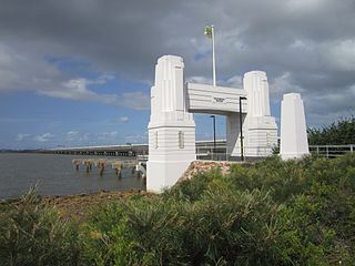
Hornibrook Bridge is a heritage-listed mostly-demolished road bridge on the Hornibrook Highway over Hays Inlet at Bramble Bay from Brighton, City of Brisbane to Clontarf, City of Moreton Bay, Queensland, Australia. It was designed by Manuel Hornibrook and built from 1932 to 1935 by Manuel Hornibrook. It was added to the Queensland Heritage Register on 7 October 1994.
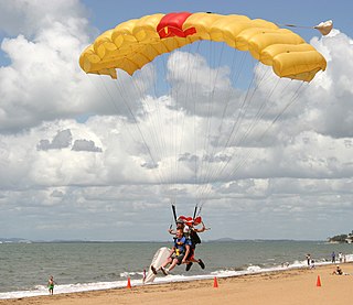
<span class="mw-page-title-main">Redcliffe, Queensland</span> Suburb of City of Moreton Bay, Queensland, Australia

Redcliffe is a town and suburb in the City of Moreton Bay, Queensland, Australia. It also refers colloquially to the Redcliffe Peninsula as a whole, a peninsula jutting into Moreton Bay which contains several other suburbs. Since the 1880s, Redcliffe has been a popular seaside resort in South East Queensland. In the 2016 census, the suburb of Redcliffe had a population of 10,373 people.

<span class="mw-page-title-main">Redcliffe Peninsula</span> Town in Queensland, Australia

The Redcliffe Peninsula is a peninsula located in the City of Moreton Bay in the northeast of the Brisbane metropolitan area in Queensland, Australia. The area covers the suburbs of Clontarf, Kippa-Ring, Margate, Newport, Redcliffe, Rothwell, Scarborough and Woody Point.

The Division of Petrie is an Australian Electoral Division in Queensland.

<span class="mw-page-title-main">Woody Point, Queensland</span> Suburb of Redcliffe, Queensland, Australia

Woody Point is a coastal suburb of Redcliffe in the City of Moreton Bay, Queensland, Australia. In the 2016 census, Woody Point had a population of 4,418 people.

<span class="mw-page-title-main">Clontarf, Queensland</span> Suburb of City of Moreton Bay, Queensland, Australia

Clontarf is a coastal suburb in the City of Moreton Bay, Queensland, Australia. In the 2021 census, Clontarf had a population of 8,446 people.

<span class="mw-page-title-main">Brighton, Queensland</span> Suburb of Brisbane, Queensland, Australia

Brighton is a coastal northern suburb of the City of Brisbane, in the state of Queensland, in Australia. In the 2021 census, Brighton had a population of 9,664 people.

<span class="mw-page-title-main">Hays Inlet</span>

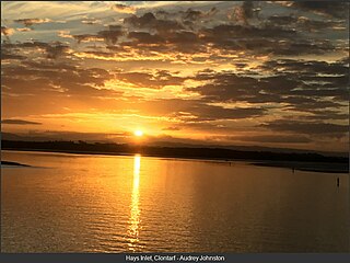
Hays Inlet is a saltwater inlet off Bramble Bay in the City of Moreton Bay, Queensland, Australia. The Brisway map reference is 420 L19. A mangrove forest is found in the inlet.

The M1 in Queensland, Australia, is a major urban road corridor. It connects the Sunshine Coast hinterland to Tugun, near the New South Wales and Queensland border, via the following corridors:

<span class="mw-page-title-main">Kippa-Ring, Queensland</span> Suburb of City of Moreton Bay, Queensland, Australia

Kippa-Ring is a suburb in the City of Moreton Bay, Queensland, Australia. In the 2021 census, Kippa-Ring had a population of 9,745 people.

<span class="mw-page-title-main">Bramble Bay</span> River in Queensland, Australia

Bramble Bay is an embayment of Moreton Bay in South East Queensland, Australia. The Brisway map reference is 12 H5, or see page 91 G19 in Refidex.

<span class="mw-page-title-main">City of Redcliffe</span> Local government area in Queensland, Australia

The City of Redcliffe is a former local government area in South East Queensland, Australia. In 2008 it was amalgamated with the Shires of Pine Rivers and Caboolture to create Moreton Bay Region, later renamed City of Moreton Bay. It is in the northern part of the County of Stanley, with a total area of 38.1 square kilometres (14.7 sq mi) and a population of 51,174 in the 2006 census.

Rothwell is a coastal suburb in the City of Moreton Bay, Queensland, Australia. In the 2021 census, Rothwell had a population of 7,538 people.

<span class="mw-page-title-main">Anzac Avenue</span> Historic site in Queensland, Australia

Anzac Avenue is a heritage-listed major arterial road lined with trees in the City of Moreton Bay, Queensland, Australia. It runs 17.8 kilometres (11.1 mi) from Petrie to Redcliffe, with most of the route signed as state route 71. The route was formerly the main route to the Redcliffe peninsula, until the Hornibrook Bridge was opened in 1935.

<span class="mw-page-title-main">Ted Smout Memorial Bridge</span> Bridge in Queensland, Australia

The Ted Smout Memorial Bridge is a road and pedestrian bridge in Brisbane, Australia, the third bridge crossing Hays Inlet in Bramble Bay. It is located 30 metres to the east of the Houghton Highway, providing 3 southbound traffic lanes and a bi-directional pedestrian and bicycle path. It connects the Redcliffe suburb of Clontarf with the Brisbane suburb of Brighton, and was opened by then Queensland Premier Anna Bligh on 11 July 2010. The Ted Smout Memorial Bridge were Australia's second longest bridges until 27 March 2013, when the Macleay River Bridge opened in Kempsey, NSW.

<span class="mw-page-title-main">Kippa-Ring railway station</span> Railway station in Queensland, Australia

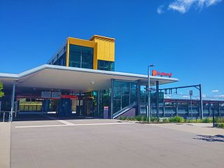
Kippa-Ring railway station is the terminus of the Redcliffe Peninsula railway line and serves the suburb of Kippa-Ring in City of Moreton Bay, Queensland, Australia. It features a park & ride facility and local bus stops. A stabling facility, capable of holding 10 six car trains, is located to the west of the station. It opened, together with the rail line, on 4 October 2016.

<span class="mw-page-title-main">Rothwell railway station</span> Railway station in Queensland, Australia

Rothwell railway station is located on the Redcliffe Peninsula railway line serving the suburb of Rothwell in City of Moreton Bay, Queensland, Australia. It opened on 4 October 2016.

<span class="mw-page-title-main">Redcliffe Fire Station</span> Historic site in Queensland, Australia

Redcliffe Fire Station is a heritage-listed former fire station at 395 Oxley Avenue, Redcliffe, City of Moreton Bay, Queensland, Australia. It was built from 1948 to 1949 by Alex Smith. It was added to the Queensland Heritage Register on 6 September 2005.

Burpengary–Caboolture Road is a continuous 8.0 kilometres (5.0 mi) road route in the City of Moreton Bay, Queensland, Australia. It is designated as part of State Route 60. It is a state-controlled district road, rated as a local road of regional significance (LRRS).

References

  1. "Things to do in Redcliffe and Bayside Region". Moreton Bay Regional Council. 2023. Retrieved 18 January 2023.
  2. "Holiday houses & accommodation in Redcliffe". home to go_. Retrieved 19 January 2023.
  3. "Former Redcliffe Peninsula District - Estimated Resident Population". Moreton Bay Regional Council. Retrieved 19 January 2023.
  4. "Road Network". Local Government and Municipal Knowledge Base. Retrieved 23 December 2022.
  5. North Coast region map (PDF) (Map). Queensland Government ©State of Queensland [CC BY 4.0]. 2020. Retrieved 2 May 2023.
  6. "North Coast district map" (PDF). Department of Transport and Main Roads ©State of Queensland [CC BY 4.0]. 2020. Retrieved 22 November 2022.
  7. 1 2 3 4 Google (28 November 2022). "Brighton to Redcliffe" (Map). Google Maps . Google. Retrieved 28 November 2022.
  8. 1 2 "Redcliffe intersections safety works". Queensland Government. 13 March 2022. Retrieved 2 July 2022.
  9. Google (22 November 2022). "Clontarf to Kippa-Ring" (Map). Google Maps . Google. Retrieved 22 November 2022.
  10. "Clontarf - Anzac Avenue (Elizabeth Avenue), construct active transport overpass". Queensland Government. Retrieved 20 January 2023.
  11. Google (22 November 2022). "Burpengary to Rothwell" (Map). Google Maps . Google. Retrieved 22 November 2022.
  12. "Bruce Highway Upgrade - Deception Bay Road Interchange". Queensland Government. Retrieved 20 January 2023.
  13. "Deception Bay Road, Bruce Highway to Park Road, duplication planning". Queensland Government. Retrieved 20 January 2023.
  14. Google (22 November 2022). "Petrie to Redcliffe" (Map). Google Maps . Google. Retrieved 22 November 2022.
  15. "Anzac Memorial Avenue (former) (entry 602693)". Queensland Heritage Register . Queensland Heritage Council. Retrieved 1 August 2014.
  16. "Hornibrook Highway Bridge (entry 601246)". Queensland Heritage Register . Queensland Heritage Council. Retrieved 1 August 2014.
  17. "Hornibrook Highway Bridge". Queensland Heritage Register. Queensland Government Environmental Protection Agency. 8 December 2006. Archived from the original on 30 September 2007. Retrieved 30 December 2006.
  18. Tony Moore (11 July 2010). "Bligh opens $315m Ted Smout Bridge". Brisbane Times . Fairfax Media. Retrieved 11 July 2010.
  19. "The Hornibrook now history". ABC Local. 14 July 2010. Retrieved 20 January 2023.