
The Pacific Motorway is a motorway in Australia between Brisbane, Queensland, and Brunswick Heads, New South Wales, through the New South Wales–Queensland border at Tweed Heads.

The Captain Cook Highway is a short, regional highway in Queensland which originates in Cairns and terminates in Mossman, where it joins Mossman-Daintree Road, continuing to Daintree. It is a state-controlled regional road.

The South Coast railway line was a railway from Brisbane, the capital city of Queensland, Australia. The route via the South Coast to Tweed Heads on the border of Queensland and New South Wales. The line operated from 1889 to 1964. The Gold Coast railway line re-opened in 1996 along a modified alignment in the north and a new route south but does not extend as far south yet as the South Coast line.
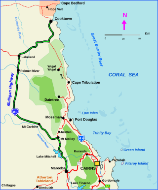
The Mulligan Highway is a state highway in Queensland, Australia. It runs for approximately 266 km between Mareeba and Cooktown, on the east coast of Cape York Peninsula where it terminates. It is signed as State Route 81 from Mareeba to Lakeland and State Route 40 from Lakeland to Cooktown. It is a state-controlled regional road.

The Gold Coast is the largest regional city and fastest growing city in Australia. As a result, the Gold Coast has a wide range of public and private transport options from cars and bikes to buses, heavy rail and light rail. The car is the dominant mode of transport in the city with an extensive arterial road network that connects the standard residential streets with major suburbs and motorways.

Gold Coast Highway links the coastal suburbs of the Gold Coast in south eastern Queensland such as Miami, Mermaid Beach, Tugun, Bilinga and across the border of New South Wales to the Tweed Heads suburb of Tweed Heads West. At 39.6 kilometres (24.6 mi) in length, the highway runs just west of Pacific Motorway at Pacific Pines to Pacific Motorway at Tweed Heads West. It passes through the numerous popular tourist areas including Surfers Paradise and Broadbeach, a commercial centre at Southport, residential areas, shopping centres and the Gold Coast (Coolangatta) Airport.
Bermuda Street is a road on the Gold Coast from Bundall to Burleigh Heads in Queensland, Australia. Originally a suburban street, it is now part of Southport – Burleigh Road, a state controlled road
Nerang–Broadbeach Road is a road on the Gold Coast, Queensland, Australia. It is classified a state-controlled district road, and is part of State Route 90. The eastern section is also known as Hooker Boulevard.
Gooding Drive is a major road on the Gold Coast, Queensland. The road begins at the intersection of Hinkler Drive in Worongary where it passes over the Pacific Motorway and runs through the suburb of Merrimac before terminating in Carrara where it joins up with Nerang - Broadbeach Road. As part of the most direct route from the Gold Coast Highway at Broadbeach to the Pacific Motorway it is a key component of Gold Coast infrastructure.
Maroochydore Road is a major arterial road on the Sunshine Coast, Queensland that connects the major town/urban centre of Maroochydore with the Bruce Highway.
Southport–Burleigh Road is a road in the city of Gold Coast in the Australian state of Queensland. It is designated as State Route 3 and runs 17.9 km (11.1 mi) from Southport to Burleigh Heads. It includes four former suburban streets, which are still known locally by their original names. They are :
Southport–Nerang Road is a major arterial road on the Gold Coast, Queensland that connects the outlying suburb of Nerang with Southport, the Gold Coast's Central Business District.
Beaudesert–Nerang Road is a major inter-regional arterial road that connects the township of Beaudesert with the Gold Coast via Canungra. The road commences in Nerang on the western edge of the Gold Coast and travels west through the Gold Coast hinterland and terminates in central Beaudesert at the intersection of Mount Lindesay Highway.
Beaudesert–Beenleigh Road is a continuous 35.5 kilometres (22.1 mi) road route in the Scenic Rim and Logan City regions of Queensland, Australia. Part of the road is signed as State Route 90 and the rest as State Route 92. Beaudesert–Beenleigh Road is a state-controlled road, part district and part regional.
Nerang–Murwillumbah Road is a continuous 36.4 kilometres (22.6 mi) road route in the Gold Coast region of Queensland, Australia. The entire road is signed as State Route 97. Nerang–Murwillumbah Road is a state-controlled district road, rated as a local road of regional significance (LRRS).
Clermont–Alpha Road is a continuous 178 kilometres (111 mi) road route in the Isaac and Barcaldine regions of Queensland, Australia. It is signed as State Route 41 for its entire length. It is a state-controlled regional road, rated as a local road of regional significance (LRRS). It is part of the shortest route from Mackay to Longreach.
Beenleigh–Redland Bay Road is a continuous 16.5 kilometres (10.3 mi) road route in the Logan and Redland local government areas of Queensland, Australia. The route is designated as part of State Route 47. It is a state-controlled district road rated as a local road of regional significance (LRRS).
The Tamborine Mountain road network is a group of roads that provide access to the mountain community from various lowland localities. The network ensures continuity of access in times of flooding or other natural disasters, and during planned maintenance activities. The locality of Tamborine Mountain includes a plateau that hosts a substantial residential community plus many tourism accommodation and activity venues.
Cooroy–Noosa Road is a continuous 12.5-kilometre (7.8 mi) road route in the Noosa local government area of Queensland, Australia. It is signed as State Route 6 for most of its length. It is a state-controlled district road for most of its length.