Surat Developmental Road

Last updated

Surat Developmental Road

Surat Developmental Road 0117.svg
Surat Developmental Road (green, outlined in black)
General information
TypeRural road
Length188 km (117 mi)
Route number(s) Australian state route 87.svg State Route 87
Major junctions
East endAustralian state route 49.svg Moonie Highway (State Route 49), Kumbarilla
 
West endAUS Alphanumeric Route A55.svg Carnarvon Highway (State Highway A55), Surat

The Surat Developmental Road (State Route 87) is a sealed road in the Western Downs Region, Queensland, Australia. It is a state-controlled district road (numbers 86A and 86B), rated as a local road of regional significance (LRRS). [1] [2]

Contents

Route description

The road branches from the Moonie Highway at a point 47 km (29 mi) west of Dalby and runs to Surat. [3] The eastern end is in the vicinity of Kumbarilla, the general direction is from east to west and its length is 188 km (117 mi). [4] Localities en route are Tara, The Gums, Meandarra and Glenmorgan.

The road passes the exit to Chinchilla–Tara Road at Tara, crosses the Leichhardt Highway (A5) at The Gums, pases exits to Meandarra–Talwood Road (to the south-west) and Condamine–Meandarra Road (to the north-east) in Meandarra, and terminates at the Carnarvon Highway (A55) at Surat.

Intersecting state-controlled roads

This road intersects with the following state-controlled roads:

Chinchilla–Tara Road

Chinchilla–Tara Road

LocationWarrego Highway, Chinchilla to Surat Developmental Road, Tara
Length70 km (43 mi)

Chinchilla–Tara Road is a state-controlled district road (number 341), rated as a local road of regional significance (LRRS). [1] [2] It runs from the Warrego Highway in Chinchilla, for 70 kilometres (43 mi) to the Surat Developmental Road in Tara. It intersects with the Kogan–Condamine Road in Crossroads and the Tara–Kogan Road in Tara. [5]

Condamine–Meandarra Road

Condamine–Meandarra Road

Australian state route 74.svg

LocationLeichhardt Highway, Condamine to Meandarra town, just north-east of Surat Developmental Road
Length51.4 km (31.9 mi)
Route number 74

Condamine–Meandarra Road is a state-controlled district road (number 345), rated as a local road of regional significance (LRRS). [1] [2] It starts at an intersection with Leichhardt Highway (A5) in Condamine. It runs south-west as State Route 74, for 51.4 kilometres (31.9 mi) to Meandarra, where it ends in the town,2.4 kilometres (1.5 mi) north-east of an intersection with Surat Developmental Road. The road has no major intersections . [6]

Meandarra–Talwood Road

Meandarra–Talwood Road

Australian state route 74.svg

LocationMeandarra town, just north-east of Surat Developmental Road, to Barwon Highway, Bungunya
Length128 km (80 mi)
Route number 74

Meandarra–Talwood Road is a state-controlled district road (number 347), rated as a local road of regional significance (LRRS). [1] [2] It starts in the town of Meandarra, 2.4 kilometres (1.5 mi) north-east of an intersection with Surat Developmental Road (State Route 87). It runs south-west as State Route 74, for 128 kilometres (80 mi) to Bungunya, where it ends at an intersection with Barwon Highway (State Route 85). The road crosses Surat Developmental Road in Meandarra and the Moonie Highway (State Route 49) in Westmar. [7] The town of Talwood is 22 kilometres (14 mi) to the south-west of Bungunya on the Barwon Highway. [8]

Associated state-controlled roads

The following state-controlled roads are associated with the intersecting roads described above:

Kogan–Condamine Road

Kogan–Condamine Road

LocationDalby–Kogan Road, Kogan to Leichhardt Highway, Condamine
Length70.2 km (43.6 mi)

Kogan–Condamine Road is a state-controlled regional road (number 342), rated as a local road of regional significance (LRRS). [1] [2] It runs from Kogan, where it transitions from Dalby–Kogan Road, for 70.2 kilometres (43.6 mi) to the Leichhardt Highway in Condamine, intersecting with the Chinchilla–Tara Road in Crossroads. [9]

Tara–Kogan Road

Tara–Kogan Road

LocationChinchilla–Tara Road, Tara to Dalby–Kogan Road, Kogan
Length43 km (27 mi)

Tara–Kogan Road is a state-controlled district road (number 3402), rated as a local road of regional significance (LRRS). [1] [2] It runs from Chinchilla–Tara Road in Tara, for 43 kilometres (27 mi) to the Dalby–Kogan Road in Kogan. [10]

Dalby–Kogan Road

Dalby–Kogan Road

LocationWarrego Highway, Dalby to Kogan–Condamine Road, Kogan
Length48.4 km (30.1 mi)

Dalby–Kogan Road is a state-controlled regional road (number 340), rated as a local road of regional significance (LRRS). [1] [2] It runs from the Warrego Highway in Dalby, for 48.4 kilometres (30.1 mi) to Kogan, where it transitions to Kogan–Condamine Road. It intersects with Daandine–Nandi Road in Macalister, and with Tara–Kogan Road and Warra–Kogan Road in Kogan. [11]

Daandine–Nandi Road

Daandine–Nandi Road

LocationDalby–Kogan Road, Macalister to Moonie Highway, Nandi
Length21 km (13 mi)

Daandine–Nandi Road is a state-controlled regional road (number 3401), rated as a local road of regional significance (LRRS). [1] [2] It runs from Dalby–Kogan Road in Macalister, for 21 kilometres (13 mi) to the Moonie Highway in Nandi. [12]

Warra–Kogan Road

Warra–Kogan Road

LocationWarrego Highway, Warra to Dalby–Kogan Road, Kogan
Length22.9 km (14.2 mi)

Warra–Kogan Road is a state-controlled district road (number 3403), rated as a local road of regional significance LRRS). [1] [2] It runs from the Warrego Highway in Warra, for 22.9 kilometres (14.2 mi) to Dalby–Kogan Road in Kogan. [13]

Major intersections

LGALocationkm [14] miDestinationsNotes
Western Downs Kumbarilla 00.0Australian state route 49.svg Moonie Highway (State Route 49) – Dalby
Tara 4125Chinchilla–Tara Road – Chinchilla, Kogan
The Gums 6943AUS Alphanumeric Route A5.svg Leichhardt Highway (State Highway A5) - Goondiwindi, Miles
Meandarra 10263Australian state route 74.svg Condamine–Meandarra Road / Meandarra–Talwood Road (State Route 74) - north - Condamine / south - Bungunya
Maranoa Surat 188117AUS Alphanumeric Route A55.svg Carnarvon Highway (State Highway A55) - St George, Roma
1.000 mi = 1.609 km; 1.000 km = 0.621 mi

See also

Related Research Articles

<span class="mw-page-title-main">Moonie Highway</span>

The Moonie Highway is a state highway of Queensland, Australia. Part of State Route 49, it leaves the Warrego Highway at Dalby and runs for over 290 km until it reaches St George. From there, State Route 49 continues west as the Balonne Highway. From Dalby, it continues north-east as the Bunya Highway.

<span class="mw-page-title-main">Burnett Highway</span> Highway in Queensland, Australia

The Burnett Highway is an inland rural highway located in Queensland, Australia. The highway runs from its junction with the Bruce Highway at Gracemere, just south of Rockhampton, to the D'Aguilar Highway in Nanango. Its length is approximately 542 kilometres. The highway takes its name from the Burnett River, which it crosses in Gayndah. The Burnett Highway provides the most direct link between the northern end of the New England Highway and Rockhampton. It is designated as a State Strategic Road by the Queensland Government.

<span class="mw-page-title-main">Bunya Highway</span> Highway in Queensland

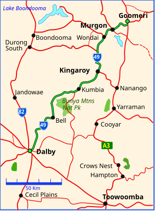
The Bunya Highway is a state highway of Queensland, Australia. It is a relatively short road, running approximately 173 kilometres in a south-westerly direction from Goomeri to Dalby. The highway connects the Warrego and Burnett Highways.

<span class="mw-page-title-main">D'Aguilar Highway</span> Highway in Queensland, Australia

The D'Aguilar Highway is a two-lane highway linking the Bruce Highway near Caboolture with the Bunya Highway in Kingaroy in the state of Queensland, Australia. Major towns along the route include Woodford, Kilcoy, Blackbutt, Yarraman, and Nanango. The highway is approximately 164 km (102 mi) in length. The D'Aguilar Highway's highest elevation along its length is 527 m just north of Yarraman, and the lowest point is at 26.8 m just west of Caboolture.

<span class="mw-page-title-main">Wide Bay Highway</span>

The Wide Bay Highway is a short state highway of Queensland, Australia running between Goomeri on the Burnett Highway and a junction on the Bruce Highway. From the junction it is 12 kilometres south to Gympie or 69 kilometres north to Maryborough. The length of the highway is 62.6 kilometres. It is a state-controlled regional road.

Kogan is a rural town and locality in the Western Downs Region, Queensland, Australia. In the 2016 census the locality of Kogan had a population of 190 people.

Maryborough–Biggenden Road is an 83.4 kilometres (51.8 mi) road route in the Fraser Coast and North Burnett regions of Queensland, Australia. The entire route is signed as State Route 86.

Gympie–Brooloo–Kenilworth Road is a continuous 51.6 kilometres (32.1 mi) road route in the Gympie and Sunshine Coast regions of Queensland, Australia. It has two official names, Gympie–Brooloo Road and Kenilworth–Brooloo Road. The entire route is signed as State Route 51.

Oakey–Cooyar Road is a continuous 58.8 kilometres (36.5 mi) road route in the Darling Downs and Toowoomba regions of Queensland, Australia. The entire route is signed as State Route 68. It is a state-controlled part regional and part district road. It provides an alternate route between the Warrego Highway and the New England Highway, bypassing Toowoomba.

Toowoomba–Karara Road is a continuous 82.5 kilometres (51.3 mi) road route in the Toowoomba and Southern Downs regions of Queensland, Australia. Most of the route is signed as State Route 48. Toowoomba–Karara Road is a state-controlled district road. As part of State Route 48 it provides an alternate route between Toowoomba and Inglewood. It is also part of the shortest route from Toowoomba to Texas.

Toowoomba–Cecil Plains Road is a continuous 78.6 kilometres (48.8 mi) road route in the Toowoomba region of Queensland, Australia. Most of the road is not signed with any route number, but a short section near Cecil Plains is part of State Route 82. Toowoomba–Cecil Plains Road is a state-controlled district road, part of which is rated as a local road of regional significance (LRRS).

Dalby–Jandowae Road is a continuous 47.3 kilometres (29.4 mi) road route in the Western Downs region of Queensland, Australia. The road is signed as State Route 82. Dalby–Jandowae Road is a state-controlled regional road.

There are two state-controlled roads linking Millmerran and Cecil Plains in the Toowoomba region of Queensland, Australia. They are Millmerran–Cecil Plains Road, which runs to the west of the Condamine River, and Pampas–Horrane Road, which runs east of the river.

The roads that join the towns of Dalby, Oakey and Cooyar form a triangle that encloses some of the most fertile land on the Darling Downs in Queensland, Australia. These roads are the Warrego Highway, Oakey–Cooyar Road and Dalby–Cooyar Road. Several of the more significant internal roads intersect with Dalby–Cooyar Road, and these are briefly described in this article, along with some significant external roads.

Bunya Mountains road network is a group of roads that provide access to the mountain community from various lowland localities. The network ensures continuity of access in times of flooding or other natural disasters, and during planned maintenance activities. The locality of Bunya Mountains includes the Bunya Mountains National Park and the enclosed locality of Mowbullan. The area hosts a small residential community plus many tourism accommodation venues.

Roma–Condamine Road is a continuous 115-kilometre (71 mi) road route in the Maranoa and Western Downs local government areas of Queensland, Australia. It is a state-controlled regional road, rated as a local road of regional significance (LRRS).

Mundubbera–Durong Road is a continuous 105-kilometre (65 mi) road route in the North Burnett and South Burnett local government areas of Queensland, Australia. It is signed as State Route 75. It is a state-controlled regional road. It has been designated as a road of strategic importance by the Federal Government.

Eumundi–Noosa Road is a continuous 15.8-kilometre (9.8 mi) road route in the Sunshine Coast and Noosa local government areas of Queensland, Australia. It is signed as State Route 12 for most of its length. For a short distance in Noosaville it is part of State Route 6. It is a state-controlled regional road for most of its length. Part of it is rated as a local road of regional significance (LRRS).

Atherton–Malanda–Millaa Millaa Road is a continuous 39.0-kilometre (24.2 mi) road route in the Tablelands local government area of Queensland, Australia. It has two official names, Malanda–Atherton Road and Millaa Millaa–Malanda Road. The entire route is signed as part of State Route 25. Malanda–Atherton Road is a state-controlled district road, while Millaa Millaa–Malanda Road is part regional and part district.

Sarina–Eton–Hampden Road is a non-continuous 62.7-kilometre (39.0 mi) road route in the Mackay local government area of Queensland, Australia. It has four official names, Sarina–Homebush Road, Eton–Homebush Road, Marian–Eton Road, and Marian–Hampden Road. The entire route is signed as State Route 5. The four roads are state-controlled, with the following characteristics:

References

  1. 1 2 3 4 5 6 7 8 9 "Southern Queensland region map" (PDF). Department of Transport and Main Roads ©State of Queensland [CC BY 4.0]. 2020. Retrieved 29 May 2023.
  2. 1 2 3 4 5 6 7 8 9 "Darling Downs district map" (PDF). Department of Transport and Main Roads ©State of Queensland [CC BY 4.0]. 2020. Retrieved 29 May 2023.
  3. Queensland Government - Department of Transport and Main Roads - Maps
  4. Australia Road and 4WD Atlas (Map). Eight Mile Plains, Queensland: Hema Maps. 2007. p. 8-9. ISBN   978-1-86500-456-3.
  5. Google (20 July 2023). "Chinchilla to Tara" (Map). Google Maps . Google. Retrieved 20 July 2023.
  6. Google (20 July 2023). "Condamine to Meandarra" (Map). Google Maps . Google. Retrieved 20 July 2023.
  7. Google (20 July 2023). "Meandarra to Bungunya" (Map). Google Maps . Google. Retrieved 20 July 2023.
  8. Google (20 July 2023). "Bungunya to Talwood" (Map). Google Maps . Google. Retrieved 20 July 2023.
  9. Google (20 July 2023). "Kogan to Condamine" (Map). Google Maps . Google. Retrieved 20 July 2023.
  10. Google (20 July 2023). "Tara to Kogan" (Map). Google Maps . Google. Retrieved 20 July 2023.
  11. Google (20 July 2023). "Dalby to Kogan" (Map). Google Maps . Google. Retrieved 20 July 2023.
  12. Google (20 July 2023). "Macalister to Nandi" (Map). Google Maps . Google. Retrieved 20 July 2023.
  13. Google (20 July 2023). "Warra to Kogan" (Map). Google Maps . Google. Retrieved 20 July 2023.
  14. Google (17 January 2017). "Surat Developmental Road" (Map). Google Maps . Google. Retrieved 17 January 2017.