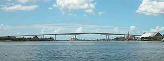
The Sir Leo Hielscher Bridges, formerly and still collectively referred to as the Gateway Bridge, are a pair of twin road bridges that carry the Gateway Motorway (M1) over the Brisbane River, skirting the eastern suburbs of the city of the same name. The western bridge carries traffic to the north and the eastern bridge carries traffic to the south. They are the most eastern crossings of the Brisbane River and the closest to Moreton Bay, crossing at the Quarries Reach and linking the suburbs of Eagle Farm and Murarrie. The original western bridge was opened on 11 January 1986 and cost A$92 million to build. The duplicate bridge was opened in May 2010, and cost $350 million.

The Bruce Highway is a major highway in Queensland, Australia. Commencing in the state capital, Brisbane, it passes through areas close to the eastern coast on its way to Cairns in Far North Queensland. The route is part of the Australian National Highway and also part of Highway 1, the longest highway route in Australia. Its length is approximately 1,679 kilometres (1,043 mi); it is entirely sealed with bitumen. The highway is named after a popular former Queensland and federal politician, Harry Bruce. Bruce was the state Minister for Works in the mid-1930s when the highway was named after him. The highway once passed through Brisbane, but was truncated at Bald Hills when the Gateway Motorway became National Highway 1 upon its opening in December 1986.

Sandgate is a northern coastal suburb in the City of Brisbane, Queensland, Australia. In the 2021 census, Sandgate had a population of 4,926 people.

Bald Hills is the northernmost suburb in the City of Brisbane, Queensland, Australia. In the 2021 census, Bald Hills had a population of 7,000 people.

Princes Motorway is a 62-kilometre (39 mi) predominantly dual carriage untolled motorway that links Sydney to Wollongong and further south through the Illawarra region to Oak Flats. Part of the Australian Highway 1 network, the motorway is designated route M1.

The Houghton Highway is a 2.74 km (1.70 mi) reinforced concrete viaduct, the second bridge to be built across Hays Inlet at Bramble Bay connecting the cities of Redcliffe and Brisbane in Queensland, Australia. The bridge, along with the third bridge, the Ted Smout Memorial Bridge, were the longest bridges in the country until 27 March 2013, when the Macleay River Bridge opened in Kempsey, NSW.
The Cunningham Highway is a 327-kilometre (203 mi) national highway located in south-eastern Queensland, Australia. The highway links the Darling Downs region with the urbanised outskirts of Ipswich via Cunninghams Gap.
The Kwinana Freeway is a 72-kilometre (45 mi) freeway in and beyond the southern suburbs of Perth, Western Australia, linking central Perth with Mandurah to the south. It is the central section of State Route 2, which continues north as Mitchell Freeway to Clarkson, and south as Forrest Highway towards Bunbury. A 4-kilometre (2.5 mi) section between Canning and Leach highways is also part of National Route 1. Along its route are interchanges with several major roads, including Roe Highway and Mandjoogoordap Drive. The northern terminus of the Kwinana Freeway is at the Narrows Bridge, which crosses the Swan River, and the southern terminus is at Pinjarra Road, east of Mandurah.

The Pacific Motorway is a motorway in Australia between Brisbane, Queensland, and Brunswick Heads, New South Wales, through the New South Wales–Queensland border at Tweed Heads.
The Northern Busway is a bus-only road running north from the Brisbane central business district to the Royal Brisbane & Women's Hospital in Queensland, Australia. The first section of the busway opened on 23 February 2004 with one station at QUT Kelvin Grove. In December 2005, Normanby and Herston stations opened.
The Gateway Motorway is a major tolled motorway in Brisbane, Queensland, Australia which includes the Sir Leo Hielscher Bridges. The motorway is operated by toll road operator Transurban.

The M2/M6 Logan Motorway is a 30-kilometre toll road between Ipswich and the M1 or Pacific Motorway at Loganholme, and the Gateway Motorway, providing access to the Gold Coast on the eastern seaboard and to the rural areas of the Darling Downs to the west. The M6 portion runs from the Pacific Motorway to the junction with the Gateway Motorway at Drewvale, where it then becomes the M2, continuing on to merge with the Ipswich Motorway at Gailes.

Brighton is a coastal northern suburb of the City of Brisbane, in the state of Queensland, in Australia. In the 2021 census, Brighton had a population of 9,664 people.
The M1 in Queensland, Australia, is a major urban road corridor. It connects the Sunshine Coast hinterland to Tugun, near the New South Wales and Queensland border, via the following corridors:

Deagon is an outer northern suburb in the City of Brisbane, Queensland, Australia. In the 2021 census, Deagon had a population of 3,773 people.
Gympie Road is a major road in the northern suburbs of Brisbane, Queensland, Australia. The road forms part of the main road route from the Brisbane Central Business District (CBD) to the northern suburbs, Sunshine Coast and east coast of Queensland.
Caloundra Road is a continuous 9.3-kilometre (5.8 mi) road route in the Sunshine Coast local government area of Queensland, Australia. Most of it is designated as part of State Route 6. It is a state-controlled district road, part of which is rated as a local road of regional significance (LRRS).
Brisbane–Woodford Road is the official name for a continuous 60.5-kilometre (37.6 mi) road route in the Moreton Bay local government area of Queensland, Australia. It is designated as part of State Route 58. It is a state-controlled road part regional and part district, rated as a local road of regional significance (LRRS).
Redcliffe Peninsula road network is a group of roads that provide access to the Redcliffe Peninsula in Queensland, Australia, and enable travel between the contained communities. The area serviced by the network includes the localities of Clontarf, Kippa-Ring, Margate, Newport, Redcliffe, Rothwell, Scarborough and Woody Point.