Kingsford Smith Drive, Brisbane

Last updated

Kingsford Smith Drive

Kingsford Smith Drive, Hamilton.jpg
Kingsford Smith Drive at Hamilton, May 2015
Kingsford Smith Drive, Brisbane
General information
TypeRoad
Length7 km (4.3 mi)
Route number(s) Australian state route 25.svg State Route 25
Major junctions
Southwest endAustralian state route 25.svg Breakfast Creek Road (State Route 25) Albion
 
Northeast endAustralian state route 25.svg Eagle Farm Road (State Route 25) Pinkenba
Location(s)
Major suburbs Hamilton, Pinkenba

Kingsford Smith Drive is a major road in Brisbane. The road was named after the aviator Charles Kingsford Smith. It connects the suburb of Pinkenba to the Brisbane central business district at the Breakfast Creek. Kingsford Smith Drive is one of the busiest roads in Brisbane, carrying an average of 61,773 vehicles per day between July and December 2014. [1]

Contents

History

Accident involving a towed plane on Kingsford Smith Drive in c. 1945 Kingsford Smith Drive plane accident.jpg
Accident involving a towed plane on Kingsford Smith Drive in c.1945

The first road along the northern bank of the Brisbane River was constructed in 1829/1830. [2] Convict labour was used to connect the main settlement to the women's gaol at Eagle Farm. [2] In 1882, the road was still no better than a rough bush track. [3]

The road was then known as Hamilton Road in one part and Eagle Farm Road in another part. In 1938, it was renamed Bailey Memorial Avenue in honour of John Frederick Bailey, Queensland Botanist and curator of the Botanic Gardens. [4] However, this name was not used in practice and, in 1953, the road was again renamed after Charles Kingsford Smith [5] although the idea of renaming it had been proposed back in 1938 when the Bailey Memorial Avenue was proposed. [6]

The road was once the major access route to Brisbane's old airport terminals. In 2002 the Inner City Bypass, Brisbane was opened. This bypass allowed traffic joining the Pacific Motorway to avoid the smaller and sometimes congested city streets. In 2016 a major upgrade project was commenced, which completed a year later than scheduled in October 2020. [7]

Route

The route runs along Hamilton Reach of the Brisbane River from Albion via Hamilton, before passing under the Gateway Motorway at Eagle Farm and continuing to Pinkenba. At Hamilton the Kingsford Smith Drive meets Racecourse Road at a T-intersection. During the annual Bridge to Brisbane the road is temporarily closed in one direction.

Congestion

Traffic congestion on Kingsford Smith Drive at Hamilton, 1954 StateLibQld 1 119880 Traffic congestion on Kingsford Smith Drive at Hamilton, 1954.jpg
Traffic congestion on Kingsford Smith Drive at Hamilton, 1954
Kingsford Smith Drive Upgrade, Looking west at Crescent Rd in July 2017 17-07-09 Kingsford Smith Drive Upgrade.jpg
Kingsford Smith Drive Upgrade, Looking west at Crescent Rd in July 2017
Kingsford Smith Drive Upgrade, Looking east at Crescent Rd in July 2017 17-07-09 Kingsford Smith Drive Upgrade 2.jpg
Kingsford Smith Drive Upgrade, Looking east at Crescent Rd in July 2017

In February 2007 it was announced by the Queensland Government that the road was to receive a major upgrade and that traffic rates were estimated at 67,000 vehicles a day. [8] Traffic volumes on the road are increasing. This has led to a drop in the average speed on the road from 45 kilometres (28 mi) per hour in 2008 to 36 kilometres (22 mi) per hour in 2009. [9] The Airport Link tolled tunnel project is expected to reduce traffic volumes by 12%. [10]

Major intersections

The entire road is in the Brisbane local government area.

LocationkmmiDestinationsNotes
Albion 00.0Australian state route 25.svg Breakfast Creek Road (State Route 25) – south – Newstead Western end of Kingsford Smith Drive (State Route 25)
Albion –
Hamilton boundary
0.150.093 Inner City Bypass – west – Bowen Hills No eastbound exit to Inner City Bypass.
No westbound entry from Inner City Bypass.
Hamilton 1.91.2 Racecourse Road – north – Ascot, Eagle Farm Racecourse
2.61.6Nudgee Road – north – Ascot, Doomben Racecourse
Remora Road – south – Portside Wharf
3.82.4 Southern Cross Way – north – Hendra No entry from Southern Cross Way.
No exit to Southern Cross Way southbound.
4.42.7Links Avenue North – south – Southern Cross Way
Schneider Road – north – Australia TradeCoast
4.93.0AUS Alphanumeric Route M1.svg Gateway Motorway – south – Sir Leo Hielscher Bridges No exit to Gateway Motorway northbound.
No entry from Gateway Motorway southbound.
Pinkenba 7.04.3Australian state route 25.svg Eagle Farm Road (State Route 25) – north–east – PinkenbaEastern end of Kingsford Smith Drive.
State Route 25 continues north–east as Eagle Farm Road.
1.000 mi = 1.609 km; 1.000 km = 0.621 mi

See also

Related Research Articles

<span class="mw-page-title-main">Sir Leo Hielscher Bridges</span> Bridges in Queensland, Australia

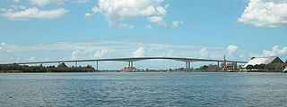
The Sir Leo Hielscher Bridges, formerly and still commonly known as the Gateway Bridge, are a side-by-side pair of road bridges on the Gateway Motorway (M1), which skirts the eastern suburbs of Brisbane, Queensland, Australia. The western bridge carries traffic to the north and the eastern bridge carries traffic to the south. They are the most eastern crossings of the Brisbane River and the closest to Moreton Bay, crossing at the Quarries Reach and linking the suburbs of Eagle Farm and Murarrie. The original western bridge was opened on 11 January 1986 and cost A$92 million to build. The duplicate bridge was opened in May 2010, and cost $350 million.

<span class="mw-page-title-main">Eagle Junction railway station</span> Railway station in Brisbane, Queensland, Australia

Eagle Junction railway station is located on the North Coast line in Queensland, Australia. It is one of two railway stations serving the Brisbane suburb of Clayfield, the other being Clayfield railway station. North of the station, the Pinkenba and Airport lines branch off.

<span class="mw-page-title-main">Doomben railway station</span> Railway station in Brisbane, Queensland, Australia

Doomben railway station is the terminal station of the Doomben line in Queensland, Australia. It serves the Brisbane suburb of Ascot adjacent to Doomben Racecourse.

<span class="mw-page-title-main">Ascot, Queensland</span> Suburb of Brisbane, Queensland, Australia

Ascot is a north-east suburb in the City of Brisbane, Queensland, Australia. In the 2016 census, Ascot had a population of 5,777 people.

<span class="mw-page-title-main">Pacific Motorway (Brisbane–Brunswick Heads)</span> Motorway in New South Wales and Queensland

The Pacific Motorway is a motorway in Australia between Brisbane, Queensland, and Brunswick Heads, New South Wales, through the New South Wales–Queensland border at Tweed Heads.

<span class="mw-page-title-main">Pinkenba, Queensland</span> Suburb of Brisbane, Queensland, Australia

Pinkenba is a town and eastern coastal suburb within the City of Brisbane, Queensland, Australia. In the 2016 census, Pinkenba had a population of 368 people.

Bridge to Brisbane is an annual long-distance fun run over a distance of 10-kilometre (6.2 mi) or 5-kilometre (3.1 mi) held in Brisbane, Australia in August.

The Gateway Motorway is a major tolled motorway in Brisbane, Queensland, Australia which includes the Sir Leo Hielscher Bridges. The motorway is operated by toll road operator Transurban.

<span class="mw-page-title-main">Eagle Farm, Queensland</span> Suburb of Brisbane, Queensland, Australia

Eagle Farm is an eastern industrial suburb of the City of Brisbane, Queensland, Australia. In the 2016 census, Eagle Farm had a population of 0 people.

TransApex was a road transport plan devised by Brisbane Lord Mayor Campbell Newman in the early 2000s to connect existing motorways and major arterial roads with new transport links and divert cross-city traffic out of the Brisbane central business district. The plan is currently being delivered by Brisbane City Council at an estimated total cost of over $10 billion across five stages. According to the Brisbane City Council website, TransApex is "the biggest urban road project proposed in Australia".

<span class="mw-page-title-main">Hendra, Queensland</span> Suburb of Brisbane, Queensland, Australia

Hendra is a suburb of the City of Brisbane, Queensland, Australia. In the 2021 census, Hendra had a population of 4,914 people.

<span class="mw-page-title-main">Clem Jones Tunnel</span> Motorway tunnel in Brisbane

The M7 Clem Jones Tunnel (CLEM7), known during its development as the North-South Bypass Tunnel (NSBT), is a A$3.2 billion motorway grade toll road under the Brisbane River, between Woolloongabba and Bowen Hills in Brisbane, Queensland. The tunnel was progressively opened to traffic from late on 15 March 2010 until just after midnight on 16 March 2010. It was completely open by 12:02 am.

<span class="mw-page-title-main">Airport Link, Brisbane</span> Motorway in Brisbane, Australia

The Airport Link is a tunnelled, motorway grade, toll road in the northern suburbs of Brisbane, Queensland, Australia. It connects the Brisbane central business district and the Clem Jones Tunnel to the East-West Arterial Road which leads to the Brisbane Airport. It was built in conjunction with the Windsor to Kedron section of the Northern Busway in approximately the same corridor.

The M1 in, Queensland, Australia, is a major urban road corridor. It connects the Sunshine Coast hinterland to Tugun, near the New South Wales and Queensland border, via the following corridors:

<span class="mw-page-title-main">Eagle Farm railway station</span> Former railway station in Brisbane, Queensland, Australia

Eagle Farm railway station is an abandoned passenger station in Brisbane, Queensland, Australia. It is on the Pinkenba railway line, only 6.8 kilometres (4.2 mi) (4.2 mi) from the Brisbane central business district; 10.9 kilometres (6.8 mi) from Central station by rail.

<span class="mw-page-title-main">Inner City Bypass, Brisbane</span>

M3 Inner City Bypass (ICB) is a 5.6 kilometres (3.5 mi) major motorway standard bypass in Brisbane, Queensland, Australia. Bypassing the Brisbane central business district to the north, it connects Brisbane’s Pacific Motorway and Go Between Bridge at Hale Street to Kingsford Smith Drive, Legacy Way Tunnel, Clem Jones Tunnel, AirportLink Tunnel and Lutwyche Road following the Exhibition railway line for the majority of its length.

<span class="mw-page-title-main">Hamilton, Queensland</span> Suburb of Brisbane, Queensland, Australia

Hamilton is an affluent riverside mixed-use suburb in the north-east of the City of Brisbane, Queensland, Australia. Hamilton is located along the north bank of the Brisbane River. In the 2021 census, Hamilton had a population of 8,922 people.

<span class="mw-page-title-main">Meeandah railway station</span> Former railway station in Brisbane, Queensland, Australia

Meeandah railway station is an abandoned station on the Pinkenba railway line in the suburb of Pinkenba, City of Brisbane, Queensland, Australia. It is 8.7 kilometres (5.4 mi) from the Brisbane central business district and 13.4 kilometres (8.3 mi) from Central station by rail. It closed as a staffed station in 1930, reopened as an unattended gate in 1931, and was finally closed on 27 September 1993.

<span class="mw-page-title-main">Brisbane Airport (suburb)</span> Suburb of Brisbane, Queensland, Australia

Brisbane Airport is a coastal suburb in the City of Brisbane, Queensland, Australia. In the 2016 census, Brisbane Airport had a population of 0 people.

<span class="mw-page-title-main">Myrtletown, Queensland</span>

Myrtletown is a former town and now industrial neighbourhood within the suburb of Pinkenba, City of Brisbane, Queensland, Australia.

References

  1. Kristian Silva (18 March 2015). "Brisbane traffic increasing, report shows". Brisbane Times. Fairfax Media. Archived from the original on 16 September 2015. Retrieved 18 March 2015.
  2. 1 2 Gregory, Helen (2007). Brisbane Then and Now. Wingfield, South Australia: Salamander Books. pp. 128–129. ISBN   978-1-74173-011-1.
  3. Cole, John R. (1984). Shaping a city. Albion, Queensland: William Brooks Queensland. p. 16. ISBN   0-85568-619-7.
  4. "Plans For Wider Roadways". The Courier-Mail . Brisbane: National Library of Australia. 30 March 1939. p. 3. Archived from the original on 22 December 2020. Retrieved 15 March 2011.
  5. "Hamilton Road". The Courier-Mail . Brisbane: National Library of Australia. 3 July 1953. p. 3. Archived from the original on 22 December 2020. Retrieved 15 March 2011.
  6. "Kingsford Smith Avenue Wanted". The Courier-Mail . Brisbane: National Library of Australia. 17 September 1938. p. 4. Archived from the original on 22 December 2020. Retrieved 15 March 2011.
  7. Stone, Lucy (27 October 2020). "Kingsford Smith Drive upgrade opens a year late but under budget". Brisbane Times. Archived from the original on 2 November 2020. Retrieved 9 December 2020.
  8. Wardill, Steven; Chalmers, Emma (26 February 2007). "Up for sale". The Courier-Mail . Archived from the original on 3 March 2007. Retrieved 10 March 2008.
  9. Tony Moore (November 2010). "East West Link v Kingsford Smith Drive: The great infrastructure stand-off". Brisbane Times . Fairfax Media. Archived from the original on 4 November 2010. Retrieved 3 November 2010.
  10. Tony Moore (4 February 2010). "Kingsford Smith Drive getting worse". Brisbane Times . Fairfax Media. Archived from the original on 6 September 2010. Retrieved 3 November 2010.

27°26′23.36″S153°03′40.58″E / 27.4398222°S 153.0612722°E / -27.4398222; 153.0612722