Route

Annerley Road commences at Stanley Street at Clarence Corner. It passes through or forms the border of the suburbs of:
It terminates at Ipswich Road at the Annerley Junction. [3]
Annerley Road is an arterial road in Brisbane, Queensland, Australia. It was formerly known as Boggo Road due to the boggy condition of the road. [1] [2]
Annerley Road commences at Stanley Street at Clarence Corner. It passes through or forms the border of the suburbs of:
It terminates at Ipswich Road at the Annerley Junction. [3]

Annerley Road has many well-known landmarks including:

Albion is an inner north-eastern suburb in the City of Brisbane, Queensland, Australia. In the 2016 census, Albion had a population of 2,296 people.
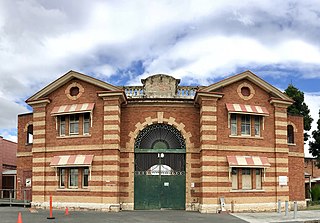
Boggo Road Gaol in Brisbane, Australia, was Queensland’s main jail from the 1880s to the 1980s, by which time it had become notorious for poor conditions and rioting. Located on Annerley Road in Dutton Park, an inner southern suburb of Brisbane, it is the only surviving intact gaol in Queensland that reflects penological principles of the 19th century. After closing in 1992, the larger 1960s section was demolished, leaving the heritage listed section, which is open to the public through guided tours run by Boggo Road Gaol Pty Ltd.

Dutton Park railway station is located on the Beenleigh line in Queensland, Australia. It serves the Brisbane suburb of Dutton Park. The station is one of the oldest on the network.

Dutton Park is an inner southern suburb in the City of Brisbane, Queensland, Australia. In the 2016 census, Dutton Park had a population of 2,024 people.

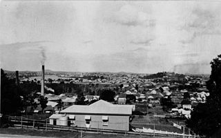
Annerley is a suburb in the City of Brisbane, Queensland, Australia. In the 2016 census, Annerley had a population of 11,336 people.
The Eastern Busway is a bus-only road running from the University of Queensland's St Lucia campus to Langlands Park busway station in Queensland, Australia.

Fairfield is a suburb of the City of Brisbane, Queensland, Australia. In the 2016 census, Fairfield had a population of 2,980 people.

Woolloongabba is a suburb in the City of Brisbane, Queensland, Australia. In the 2016 census, Woolloongabba had a population of 5,631 people.

Yeronga is a southern riverside suburb in the City of Brisbane, Queensland, Australia. In the 2016 census, Yeronga had a population of 6,535 people.

Spring Hill is an inner northern suburb in the City of Brisbane, Queensland, Australia. In the 2016 census, Spring Hill had a population of 5,974 people.

Ipswich Road is one Brisbane's main roads connecting Brisbane to the nearby city of Ipswich, via the Ipswich Motorway. Ipswich Road used to be part of the Cunningham Highway. Logan Road, Pacific Motorway, and Beaudesert Road are the other major roads in the south of Brisbane. The road was an important transport route in 19th century Brisbane.
Stanley Street is a major street in Brisbane, Queensland. It carries the designation state route 41 for the entirety of its length and state route 10 between the Vulture Street and Annerley Road intersections. For the majority of its length the road is a one-way carriageway westbound. The route is a major connector between the Southern and Eastern suburbs and South Brisbane. The street passes directly to the south of The Gabba and runs directly through the Mater Hospital precinct.
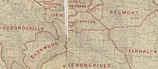
The Shire of Stephens was a local government area in the inner southern suburbs of Brisbane, Queensland, Australia. The shire, administered from Annerley, covered an area of 9 square miles (23 km2), and existed as a local government entity from 1886 until 1925, when it was amalgamated into the City of Brisbane under the City of Brisbane Act 1924.
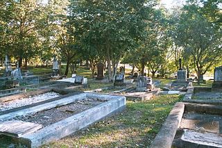
South Brisbane Cemetery is a heritage-listed cemetery at 21 Fairfield Road and Annerley Road, Dutton Park, City of Brisbane, Queensland, Australia, adjacent to the Brisbane River. It was built from 1870 to 1990s. It is also known as Dutton Park Cemetery. It was added to the Queensland Heritage Register on 1 October 2003.
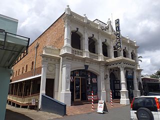
Princess Theatre is a heritage-listed theatre at 8 Annerley Road, Woolloongabba, Queensland, Australia. It was designed by architect John Beauchamp Nicholson and built in 1888. It is also known as South Brisbane Public Hall and Boggo Road Theatre. It was added to the Queensland Heritage Register on 21 October 1992.

Gair Park is a heritage-listed park and memorial at 181 Annerley Road, Dutton Park, City of Brisbane, Queensland, Australia. It was built from 1936 onwards. It was added to the Queensland Heritage Register on 5 April 2004.

Clarence Corner is the junction of Stanley Street and Annerley Road in Woolloongabba/South Brisbane in Brisbane, Queensland, Australia. It gives its name to the local area.

Pollock's Shop House is a heritage-listed general store at 617-619 Stanley Street, Woolloongabba, City of Brisbane, Queensland, Australia. It was built c. 1865. It was added to the Queensland Heritage Register on 21 October 1992.
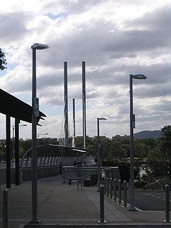
Dutton Park Place busway station is located in Brisbane, Australia serving the suburb of Dutton Park. It is the penultimate westbound stop on the Eastern Busway.

Dutton Park State School is a heritage-listed government primary school at 112 Annerley Road, Dutton Park, City of Brisbane, Queensland, Australia. It was built from 1916 to 1934. It was also known as Woolloongabba State School, Woolloongabba Boys State School, and Dutton Park Boys State School. It was added to the Queensland Heritage Register on 30 November 2018.
| Wikimedia Commons has media related to Annerley Road . |