Gair Park | |
---|---|
Location | 181 Annerley Road, Dutton Park, City of Brisbane, Queensland, Australia |
Coordinates | 27°29′48″S153°01′39″E / 27.4967°S 153.0274°E |
Design period | 1919–1930s (interwar period) |
Built | 1936– |
Official name | Gair Park |
Type | state heritage (landscape, built) |
Designated | 5 April 2004 |
Reference no. | 602429 |
Significant period | 1930s–ongoing (fabric) 1936–ongoing (historical park use) 1951–ongoing (historical memorial use) |
Significant components | seating, memorial – obelisk, memorial – plaque, trees/plantings, shed – shelter, tree groups – avenue of, fence/wall – perimeter |
Gair Park is a heritage-listed park and memorial at 181 Annerley Road, Dutton Park, City of Brisbane, Queensland, Australia. It was built from 1936 onwards. It was added to the Queensland Heritage Register on 5 April 2004. [1]
Gair Park is a triangular area of land at the intersection of two major roads at Dutton Park and was developed as a park in 1936 and as a garden of remembrance and memorial following World War II. It now also commemorates subsequent conflicts. [1]
The area now that is now known as Dutton Park was originally called Bloggo or Boggo. It was thickly timbered and cut by steep gullies. Some farms were established there in the 1840s, but there were few houses until the 1880s. As transport became available, more people moved to the district. Dutton Park railway station opened in 1884 and the first horse-drawn bus service linking Dutton Park with the Brisbane CBD began in 1890. It was replaced by electric tram in 1908, after which the area developed more rapidly. In 1914 the suburb was renamed in honour of Charles Boydell Dutton, Secretary of Public Lands between 1883 and 1887, and by the late 1920s, was considered a fashionable suburb. [1]
In the 30 June 1929 edition of the Sunday Mail, an article generally praising the suburb commented unfavourably on the area at the intersection of Annerley Road and Gladstone Road where there was: [1] [2]
"a vacant triangle of public land which would make a charming little tree shaded reserve, but at the present time it remains little more than a rubbish heap, that is more of a disfigurement to the locality than an acquisition, which it would be if tided up and planted with shade trees"
Steps were taken to address this problem in 1936 when the area, previously part of the road reserve, was vested in the Brisbane City Council for general municipal purposes. It was reserved as a park and Gilchrist prepared plans for it in June 1936. In 1938 the planting of fifty trees furthered the development. [1]
The new park was named Gair Park in honour of parliamentarian Vincent (Vince) Clair Gair, Labor Member of the Queensland Legislative Assembly for South Brisbane. Born in Rockhampton in 1901, Gair moved to Dutton Park with his parents in 1916. His family was politically active and he became Secretary of the South Brisbane branch of the Australian Labor Party and by 1924 was its president. He was first elected to the Queensland Parliament in 1932 and gained his first Ministry as Secretary for Mines in 1942. He became Minister for Labour and Employment 1944-50 and Deputy Premier in 1947. In 1950 he became Treasurer and was Queensland Premier in 1951. He introduced the 40-hour working week and was associated with the modernisation of the Factory and Shops Act. In 1957 he was expelled from the Labor Party following a divergence of opinion and became leader of the breakaway Democratic Labor Party in 1964. He was an Australian Senator for the DLP between 1965 and 1973, and then took up the appointment of Ambassador for Ireland until 1976 when he withdrew from politics. He lived locally until his death in 1980 and was always active in his constituency, supporting local institutions particularly those associated with health and children's welfare. [1]
Following World War II, the Dutton Park and District Progress Association applied for permission to build a Memorial Hall. The Brisbane City Council did not favour this scheme and it was suggested that they lease a portion of Dutton Park instead. However, the proposal of the Dutton Park sub-branch of the RSSAILA to develop Gair Park as a Garden of Remembrance with a suitable memorial was approved. The Brisbane City Council Building and Planning Branch prepared plans in 1949. The memorial was in the form of a masonry obelisk set with bronze memorial tablets placed on a plinth of sufficient depth to accommodate the laying of wreaths. It was situated at a corner of the park, at the crest of the rise, and was approached through an avenue of shrubs and hedges. Hugh McKernan constructed the memorial, which was unveiled on Anzac Day 1951 by Lieutenant-General Sir John Lavarack, Governor of Queensland. To the members of the Dutton Park sub-branch it was a major achievement and represented the transformation of what was by then described as an unkept piece of ground into a place of beauty. [1] [3]
Australia, and Queensland in particular, had few civic monuments before World War I. The memorials erected in its wake became our first national monuments, recording the devastating impact of war on a young nation. Australia lost 60,000 from a population of about 4 million, representing one in five of those who served. No previous or subsequent war has made such an impact on the nation and the majority of Australian war memorials date from this era. Monumental memorials built following World War II and subsequent conflicts are less common and many comprise additions to earlier memorials or practical projects, such as public recreational facilities. As a cenotaph in a Garden of Remembrance dating from World War II, therefore, the memorial is of a less common type in Queensland. It has had memorials to previous and subsequent conflicts added to it. [1]
The park setting has become less formal over time. In 1954 approval was given for the construction of a small concrete wall along the full length of the Annerley Road frontage with recesses for park seats and a new flowerbed in the Gladstone and Annerley Road corner. In the 1960s an avenue of eucalypts replaced earlier plantings. In 1973-74 the Multiple Sclerosis Society requested tables and chairs be provided to encourage use of the park by the inmates of the nearby convalescent home. The park now contains a picnic area and a number of shelters. [1]
Gair Park is now used for informal outdoor recreational, cultural and educational activities. Ceremonies are held there on Anzac Day to honour war dead. [1]
Gair Park, a garden of remembrance containing a cenotaph, is a triangular piece of land bounded by Annerley Road, Gladstone Road and Maldon Street at Dutton Park. It is undulating in form and slopes down towards the road junction. The northeast corner has been truncated to close access to Maldon Street from Annerley Road and a side road has been cut to the south linking Gladstone Road and Annerley Road. [1]
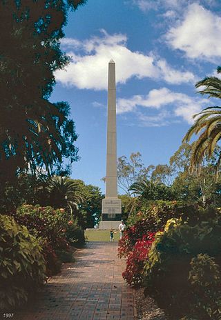
The memorial is situated near the western corner of the park at the top of a grassy avenue flanked by hedges and eucalypt trees. It is in the form of an obelisk, 20 feet (6.1 m) high and square in section composed of coursed blocks of Brisbane tuff (porphyry). It is set on a sloping plinth faced with masonry tiles and is surrounded by a paved area. Bronze memorial tablets beneath bronze laurel wreaths are set low on the sides of the shaft. These are inscribed "In Memory of Fallen Comrades" with the dates beneath commemorating the First and Second World Wars and the Korean, Malaya, Vietnam and Borneo conflicts. The fourth plaque commemorates the dedication of the memorial and is inscribed "Unveiled by his Excellency the Governor of Queensland Lieutenant General Sir John Laverack KBE, CB, CMG, DSO and dedicated by Reverend A G Reilly on 25 April 1951". [1]
On the plinth are plaques inscribed "Lest We Forget. Dutton Park sub branch RSSAILA" and "Lest We Forget. Yeronga, Dutton Park RSL Branch. Merged 3.2.1964". The park also contains a number of park seats and timber shelters and scattered plantings. [1]
Gair Park was listed on the Queensland Heritage Register on 5 April 2004 having satisfied the following criteria. [1]
The place is important in demonstrating the evolution or pattern of Queensland's history.
Gair Park is a garden of remembrance and cenotaph commemorating the war dead of the Dutton Park district. Memorials that pay tribute to war dead are an important element of Queensland towns and cities and demonstrate the way in which involvement in war has helped to shape the pattern of Queensland's history. They represent a conscious expression of Australian patriotism and sense of nationhood and reflect the public taste and social attitudes of their time. [1]
The place is important in demonstrating the principal characteristics of a particular class of cultural places.
A high proportion of war memorials in Queensland were built to commemorate World War I. Gair Park is less common in that the garden and cenotaph were constructed following World War II. After this conflict, adding to existing memorials or constructing practical memorials, such as public facilities, more commonly remembered the fallen. Gair Park is a good example of it type as a cenotaph in a formal garden of remembrance. [1]
The place is important because of its aesthetic significance.
Gair Park is important for the aesthetic qualities of both the parkland setting and the war memorial it contains. The cenotaph is dramatically sited at the top of a grassy slope rising above Annerley Road at a major traffic intersection and is a landmark in the area. [1]
The place has a strong or special association with a particular community or cultural group for social, cultural or spiritual reasons.
Gair Park and its memorial have a strong association with the community of Dutton Park as evidence of the impact of a major historic event on the district and also as a major project of the Dutton Park sub branch of the RSSAILA (now RSL). It is also an important ceremonial and recreational venue. [1]
The place has a special association with the life or work of a particular person, group or organisation of importance in Queensland's history.
Gair Park is linked to the life and work of former Queensland Premier, Vincent Clair Gair (1902–1980), and its naming acknowledges his active support for the area while Member of the Legislative Assembly for South Brisbane. [1]
Vincent Clair Gair was an Australian politician. He served as Premier of Queensland from 1952 until 1957, when his stormy relations with the trade union movement saw him expelled from the Labor Party. He was elected to the Australian Senate and led the Democratic Labor Party from 1965 to 1973. In 1974 he was appointed Australian Ambassador to Ireland by the Whitlam government, which caused his expulsion from the DLP.
Dutton Park is an inner southern suburb in the City of Brisbane, Queensland, Australia. In the 2016 census, Dutton Park had a population of 2,024 people.
ANZAC Square is a heritage-listed town square and war memorial located between Ann Street and Adelaide Street, in Brisbane, Queensland, Australia. It is a state memorial to the men and women who participated in overseas armed service and is named in honour of the Australian and New Zealand Army Corps. ANZAC Square is adjacent to ANZAC Square Arcade.
Yeronga Memorial Park is a heritage-listed park at Ipswich Road, Yeronga, City of Brisbane, Queensland, Australia. The park has an area of 224,600 square metres (2,418,000 sq ft) and is one of the oldest in Brisbane, having been established in 1882, and has been a World War I memorial since 1917. It was added to the Queensland Heritage Register on 2 December 2005.
Ipswich Road is major road in the City of Brisbane, Queensland, Australia. The road has been an important transport route since the 19th century when it connected the towns of Brisbane and Ipswich. In the 1990s, the section from Moorooka in Brisbane to Riverview in Ipswich was replaced by the Ipswich Motorway.
The Sydney Cenotaph is a heritage-listed monument located in Martin Place, in Sydney, New South Wales, Australia. It was designed by Bertram Mackennal and built from 1927 to 1929 by Dorman Long & Co. It is also known as Martin Place Memorial and The Cenotaph. It is one of the oldest World War I monuments in central Sydney. It was added to the New South Wales State Heritage Register on 11 November 2009.
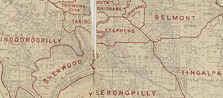
The Shire of Stephens was a local government area in the inner southern suburbs of Brisbane, Queensland, Australia. The shire, administered from Annerley, covered an area of 9 square miles (23 km2), and existed as a local government entity from 1886 until 1925, when it was amalgamated into the City of Brisbane under the City of Brisbane Act 1924.
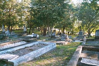
South Brisbane Cemetery, also known as Dutton Park Cemetery, is a heritage-listed cemetery at 21 Fairfield Road and Annerley Road, Dutton Park, City of Brisbane, Queensland, Australia, adjacent to the Brisbane River. It was built from 1870 to 1990s. It was added to the Queensland Heritage Register on 1 October 2003.
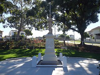
Manly War Memorial is a heritage-listed memorial at 184 Carlton Terrace, Manly, City of Brisbane, Queensland, Australia. It was built from 1920 to 1921. It is also known as Ferguson Street Reserve, Manly Dam, and Soldiers Memorial Park. It was added to the Queensland Heritage Register on 21 August 1992.
Oxley War Memorial is a heritage-listed memorial at 1218 Oxley Road, Oxley, Queensland, Australia. It was built in 1920. It is also known as Oxley Memorial Park and Oxley Place. It was added to the Queensland Heritage Register on 4 July 2006.
Annerley Road is an arterial road in Brisbane, Queensland, Australia. It was formerly known as Boggo Road due to the boggy condition of the road.
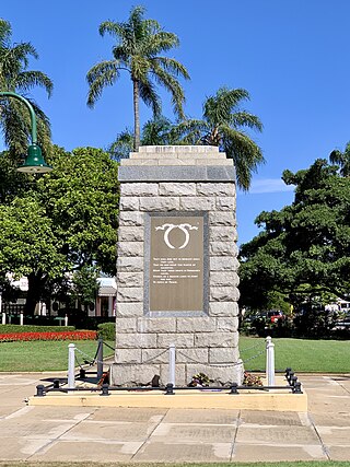
Sandgate War Memorial Park is a heritage-listed memorial at 8 Seymour Street, Sandgate, City of Brisbane, Queensland, Australia. It was designed by George Gray Prentice and built from 1923 to 1924 by Lowther & Sons. It was added to the Queensland Heritage Register on 3 October 2005.
Anning Monument is a heritage-listed memorial at the corner of Hemmant and Tingalpa Road and Boonoo Street, Hemmant, City of Brisbane, Queensland, Australia. It was designed and built by William Busby in 1903. It is also known as Hemmant Boer War Memorial. It was added to the Queensland Heritage Register on 21 October 1992.
Gympie and Widgee War Memorial Gates is a heritage-listed memorial at Mary Street, Gympie, Gympie Region, Queensland, Australia. The gates provide an entranceway on Mary Street through to the Gympie Memorial Park in Reef Street. The gates were designed by George Rae and built in 1920 by A L Petrie & Son. It was added to the Queensland Heritage Register on 21 October 1992.
Rockhampton War Memorial is a heritage-listed memorial in the Rockhampton Botanic Gardens at Penlington Street, The Range, Rockhampton, Rockhampton Region, Queensland, Australia. It was built in 1924. It was added to the Queensland Heritage Register on 21 October 1992.
World War I Cenotaph is a heritage-listed memorial at Jubilee Park, Alfred Street, Mackay, Mackay Region, Queensland, Australia. It was designed by Stephen Harvey and built from 1928 to 1929 by Melrose & Fenwick. It is also known as Mackay War Memorial and Jubilee Park. It was added to the Queensland Heritage Register on 21 August 1992.
War Memorial and Heroes Avenue is a heritage-listed memorial at Bungil Street, Roma, Maranoa Region, Queensland, Australia. It was built in 1920. It was added to the Queensland Heritage Register on 21 October 1992.
Pialba Memorial Cenotaph is a heritage-listed memorial at Freedom Park, Main Street, Pialba, Fraser Coast Region, Queensland, Australia. It was designed by Philip Oliver Ellard Hawkes and built from 1918 to 1921 by Frederick William Webb. It was added to the Queensland Heritage Register on 6 May 2016. It is also known as the Pialba War Memorial and the Hervey Bay War Memorial.
Dutton Park State School is a heritage-listed government primary school at 112 Annerley Road, Dutton Park, City of Brisbane, Queensland, Australia. It was built from 1916 to 1934. It was also known as Woolloongabba State School, Woolloongabba Boys State School, and Dutton Park Boys State School. It was added to the Queensland Heritage Register on 30 November 2018.
This Wikipedia article was originally based on "The Queensland heritage register" published by the State of Queensland under CC-BY 3.0 AU licence (accessed on 7 July 2014, archived on 8 October 2014). The geo-coordinates were originally computed from the "Queensland heritage register boundaries" published by the State of Queensland under CC-BY 3.0 AU licence (accessed on 5 September 2014, archived on 15 October 2014).
Media related to Gair Park at Wikimedia Commons