
Clarence Corner is the junction of Stanley Street and Annerley Road (formerly Boggo Road) in Woolloongabba/South Brisbane in Brisbane, Queensland, Australia. [1] It gives its name to the local area.
Clarence Corner is the junction of Stanley Street and Annerley Road (formerly Boggo Road) in Woolloongabba/South Brisbane in Brisbane, Queensland, Australia. [1] It gives its name to the local area.

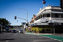
The area takes its name from the Clarence Hotel that stood on the south-east corner of the intersection. The hotel was erected by builder Thomas Hayselden and the hotel obtained its licence on 8 December 1863; the reason for the choice of name is not known but may have been named after the 500-ton steamship Clarence that plied between Brisbane and Sydney at that time. After installing Richard Overland as licensee in 1864, Hayselden then went on to construct the Albion Hotel which gave its name to the suburb of Albion today. [2] [3] The Clarence Hotel was a popular spot with the bullock teamsters travelling along Boggo Road which was the shorter but hillier route to Ipswich. [4]
In 1889, the Clarence Hotel was replaced by the present hotel, now known as the Clarence Corner Hotel. By that time, the area had developed as a residential and commercial district and the new hotel was built to attract that clientele. In 2014, the Clarence Corner Hotel is still in operation as a hotel, though operates now under the name 'Brisbane Brewing Co. Woolloongabba' and is listed on the Brisbane Heritage Register. [4] However, its clientele are more likely to be drawn from the major Mater Hospital complex that now dominates the western and northern sides of Clarence Corner.

Albion is an inner north-eastern suburb in the City of Brisbane, Queensland, Australia. In the 2021 census, Albion had a population of 3,446 people.

Kangaroo Point is an inner southern suburb in the City of Brisbane, Queensland, Australia. In the 2021 census, Kangaroo Point had a population of 9,689 people.
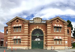
H.M. Prison Brisbane, more commonly known as Boggo Road Gaol, was Queensland's main prison from the 1880s to the 1980s. By the time it closed, it had become notorious for poor conditions and rioting. Located on Annerley Road in Dutton Park, an inner southern suburb of Brisbane, it is the only surviving intact gaol in Queensland that reflects penological principles of the 19th century. After closing in 1992, the larger 1960s section was demolished, leaving the heritage listed section.

Coorparoo is a suburb in the inner City of Brisbane, Queensland, Australia. In the 2021 census, Coorparoo had a population of 18,132 people.

Dutton Park is an inner southern suburb in the City of Brisbane, Queensland, Australia. In the 2021 census, Dutton Park had a population of 2,134 people.

Annerley is a suburb in the City of Brisbane, Queensland, Australia. In the 2021 census, Annerley had a population of 11,891 people.

Kedron is a northern suburb in the City of Brisbane, Queensland, Australia. It is home to the Queensland Fire and Emergency Services headquarters. In the 2021 census, Kedron had a population of 9,907 people.

Woolloongabba is an inner southern suburb in the City of Brisbane, Queensland, Australia. In the 2021 census, Woolloongabba had a population of 8,687 people.

Newstead is an inner northern riverside suburb of Brisbane, Queensland, Australia. In the 2021 census, Newstead had a population of 7,496 people.

Yeronga is a southern riverside suburb in the City of Brisbane, Queensland, Australia. In the 2021 census, Yeronga had a population of 7,062 people.

East Brisbane is an inner southern suburb of the City of Brisbane, Queensland, Australia. In the 2021 census, East Brisbane had a population of 6,186 people.

Ipswich Road is major road in the City of Brisbane, Queensland, Australia. The road has been an important transport route since the 19th century when it connected the towns of Brisbane and Ipswich. In the 1990s, the section from Moorooka in Brisbane to Riverview in Ipswich was replaced by the Ipswich Motorway.
The Town of Ithaca is a former local government area of Queensland, Australia, located in inner western Brisbane.
Stanley Street is a major street in Brisbane, Queensland. It carries the designation state route 41 for the entirety of its length and state route 10 between the Vulture Street and Annerley Road intersections. For the majority of its length the road is a one-way carriageway westbound. The route is a major connector between the Southern and Eastern suburbs and South Brisbane. The street passes directly to the south of The Gabba and runs directly through the Mater Hospital precinct.
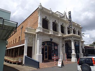
Princess Theatre is a heritage-listed theatre at 8 Annerley Road, Woolloongabba, Queensland, Australia. It was designed by architect John Beauchamp Nicholson and built in 1888. It is also known as South Brisbane Public Hall and Boggo Road Theatre. It was added to the Queensland Heritage Register on 21 October 1992.
Annerley Road is an arterial road in Brisbane, Queensland, Australia. It was formerly known as Boggo Road due to the boggy condition of the road.

Norman Hotel is a heritage-listed hotel at 102 Ipswich Road, Woolloongabba, City of Brisbane, Queensland, Australia. It was designed by John Beauchamp Nicholson and built from 1889 to 1890. It was added to the Queensland Heritage Register on 12 July 2005.
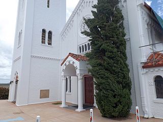
Holy Trinity Anglican Church is a heritage-listed Anglican church at 68 Hawthorne Street, Woolloongabba, Brisbane, Queensland, Australia. Since 1869, three church buildings have stood on this hill top site. The current church was completed in 1930. It was designed by the architect Eric Ford, featuring Romanesque and Spanish Mission Revival style architecture. Its preserved original architectural features make the church a traditional wedding venue of inner Brisbane. The church was added to the Queensland Heritage Register on 9 May 2008.

Pollock's Shop House is a heritage-listed general store at 617–619 Stanley Street, Woolloongabba, City of Brisbane, Queensland, Australia. It was built c. 1865. It was added to the Queensland Heritage Register on 21 October 1992.
Charles McLay was a Scottish-born architect in Queensland, Australia. Some of his works are now heritage-listed.
![]() Media related to Clarence Corner, Woolloongabba at Wikimedia Commons
Media related to Clarence Corner, Woolloongabba at Wikimedia Commons