Stanley Street, Brisbane

Last updated

Stanley Street

General information
Type Street
Length1.5 km (0.9 mi)
Route number(s)
  • Australian state route 41.svg State Route 41
  • Australian state route 10.svg State Route 10
Major junctions
West end South Brisbane
East end Woolloongabba
Location(s)
Suburb(s) Woolloongabba

Stanley Street is a major street in Brisbane, Queensland. It carries the designation state route 41 for the entirety of its length and state route 10 between the Vulture Street and Annerley Road intersections. For the majority of its length the road is a one-way carriageway westbound. The route is a major connector between the Southern and Eastern suburbs and South Brisbane. The street passes directly to the south of The Gabba and runs directly through the Mater Hospital precinct.

Brisbane capital city of Queensland, Australia

Brisbane is the capital of and the most populated city in the Australian state of Queensland, and the third most populous city in Australia. Brisbane's metropolitan area has a population of approximately 2.5 million as of 30 June 2018, and the South East Queensland metropolitan region, centred on Brisbane, encompasses a population of more than 3.6 million.

Queensland North-east state of Australia

Queensland is the second-largest and third-most populous state in the Commonwealth of Australia. Situated in the north-east of the country, it is bordered by the Northern Territory, South Australia and New South Wales to the west, south-west and south respectively. To the east, Queensland is bordered by the Coral Sea and Pacific Ocean. To its north is the Torres Strait, with Papua New Guinea located less than 200 km across it from the mainland. The state is the world's sixth-largest sub-national entity, with an area of 1,852,642 square kilometres (715,309 sq mi).

Vulture Street, Brisbane

Vulture Street is a road in Brisbane, Queensland, Australia. It connects the inner southern suburbs. Its eastern segment is known as Vulture Street East.

Contents

Stanley Street is accessible via exit 2 on the Pacific Motorway.

Pacific Motorway (Brisbane–Brunswick Heads) motorway in New South Wales and Queensland

The Pacific Motorway is a motorway in Australia between Brisbane, Queensland, and Brunswick Heads, New South Wales, through the New South Wales–Queensland border at Tweed Heads.

History

Stanley Street was named after Frederick Stanley, 16th Earl of Derby, the United Kingdom's Colonial Secretary, 1885-1886.

Frederick Stanley, 16th Earl of Derby 19th and 20th-century British politician and Governor General of Canada

Frederick Arthur Stanley, 16th Earl of Derby,, styled as Hon. Frederick Stanley from 1844–86 and as Lord Stanley of Preston between 1886–93, was a Conservative Party politician in the United Kingdom who served as Colonial Secretary from 1885 to 1886 and the sixth Governor General of Canada from 1888 to 1893. An avid sportsman, he built Stanley House Stables in England and is famous in North America for presenting Canada with the Stanley Cup. Stanley was also one of the original inductees of the Hockey Hall of Fame.

United Kingdom Country in Europe

The United Kingdom of Great Britain and Northern Ireland, commonly known as the United Kingdom (UK) or Britain, is a sovereign country located off the north-western coast of the European mainland. The United Kingdom includes the island of Great Britain, the north-eastern part of the island of Ireland, and many smaller islands. Northern Ireland is the only part of the United Kingdom that shares a land border with another sovereign state, the Republic of Ireland. Apart from this land border, the United Kingdom is surrounded by the Atlantic Ocean, with the North Sea to the east, the English Channel to the south and the Celtic Sea to the south-west, giving it the 12th-longest coastline in the world. The Irish Sea separates Great Britain and Ireland. The United Kingdom's 242,500 square kilometres (93,600 sq mi) were home to an estimated 66.0 million inhabitants in 2017.

Secretary of State for the Colonies British Cabinet minister in charge of managing the United Kingdoms various colonial dependencies

The Secretary of State for the Colonies or Colonial Secretary was the British Cabinet minister in charge of managing the United Kingdom's various colonial dependencies.

In the late 1880s, at least two hotels were built on Stanley Street, the Brisbane Bridge Hotel and Graham's Hotel. [1] Stanley Street used to continue past the Vulture Street intersection, and follow the Brisbane River north to Kurilpa Point. At this time South Brisbane was an industrial area. The road between Melbourne Street and Vulture Street was removed to make way for the construction of the Expo '88 World's Fair precinct. The precinct was converted to South Bank Parklands after the Expo. At this time a small section of the route north of Vulture Street between Tribune and Glenelg Streets was renamed Little Stanley Street.

Brisbane River river in Australia

The Brisbane River is the longest river in South-East Queensland, Australia, and flows through the city of Brisbane, before emptying into Moreton Bay. John Oxley, the first European to explore the river, named it after the Governor of New South Wales, Sir Thomas Brisbane in 1823. The penal colony of Moreton Bay later adopted the same name, eventually becoming the present city of Brisbane.

South Brisbane, Queensland Suburb of Brisbane, Queensland, Australia

South Brisbane is an inner city suburb of Brisbane, Australia on the southern bank of the Brisbane River, directly connected to the central business district by the Kurilpa, Victoria and Goodwill bridges. Its population was estimated to be 7,196 at the 2016 Australian Census.

South Bank Parklands Brisbane parkland

The South Bank Parklands are located at South Bank in Brisbane, Queensland, Australia. The parkland, on the transformed site of Brisbane's World Expo 88, was officially opened to the public on 20 June 1992.

In 2006, with the construction of the Queensland Gallery of Modern Art, the section of road still named Stanley street which tunneled under the Queensland Art Gallery was renamed Cultural Centre Tunnel and the road to the north was removed to make way for construction. A new section of road slightly to the west of the old road was built and named Stanley Place.

Queensland Art Gallery Art museum in Queensland, Australia

The Queensland Art Gallery (QAG) is an art museum located in the South Bank precinct of Brisbane, Queensland, Australia. The gallery is part of the Queensland Cultural Centre. It complements the Gallery of Modern Art (GOMA) building, situated only 150 metres (490 ft) away.

Of the old Stanley Street in South Brisbane, only a section about 100 m long, running alongside the Queensland Maritime Museum remains. The remainder has been built over by the Gallery of Modern Art and South Bank Parklands, rebuilt as a pedestrian plaza as part of the Parklands (Stanley Street Plaza and the Cultural Forecourt); or renamed.

The Queensland Maritime Museum is located on the southern bank of the Brisbane River just south of the South Bank Parklands and Queensland Cultural Centre precinct of Brisbane, and close to the Goodwill Bridge.

Significant features

On Stanley Street between the intersection with Vulture Street and Annerley Road, there is a major hospital precinct including Queensland Children's Hospital and the Mater Public Hospital.

The Stanley Street junction with Annerley Road (formerly Boggo Road) at Woolloongabba/South Brisbane is known as Clarence Corner.

The Stanley Street intersection with Ipswich Road, Logan Road and Main Street at Woolloongabba is known as the Woolloongabba Fiveways and features The Gabba sports ground.

Major intersections

The entire road is in the Brisbane local government area. [2]

LocationkmmiDestinationsNotes
Woolloongabba -
East Brisbane boundary
00.0Australian state route 41.svg Stanley Street East (State Route 41) - east - East Brisbane /
Australian state route 95.svg Wellington Road - north - East Brisbane /
south - East Brisbane
Eastern end of Stanley Street (State Route 41)
Woolloongabba 0.40.25Australian state route 15.svg Main Street (State Route 15) - north - Kangaroo Point /
Australian state route 15.svg Ipswich Road (State Route 15) - south - Annerley
0.7–
0.9
0.43–
0.56
AUS Alphanumeric Route M3.svg Pacific Motorway - north-west - Brisbane City /
south-east - Greenslopes
No exit from Stanley Street eastbound to Pacific Motorway southbound
Woolloongabba -
South Brisbane boundary
1.10.68Australian state route 10.svg Annerley Road - (State Route 10) - south - Dutton Park Eastern concurrency terminus with State Route 10
South Brisbane 1.50.93Australian state route 10.svg Vulture Street - (State Route 10) - west - West End /
Australian state route 41.svg Vulture Street - (State Route 41) - east - Woolloongabba
Western concurrency terminus with State Route 10.
Western end of Stanley Street.
1.000 mi = 1.609 km; 1.000 km = 0.621 mi

See also

Related Research Articles

Dutton Park, Queensland Suburb of Brisbane, Queensland, Australia

Dutton Park is a suburb of Brisbane, Australia located about 4 kilometres (2.5 mi) south of the Brisbane CBD. The suburb is predominantly residential, with some light industrial and commercial areas.

Woolloongabba Suburb of Brisbane, Queensland, Australia

Woolloongabba is a suburb of Brisbane, Australia. It is located 2 kilometres (1.2 mi) south-east of the CBD, and contains the Brisbane Cricket Ground and the Princess Alexandra Hospital. It is crossed by several major roads including the Pacific Motorway. The suburb was once home to a large tram depot.

Cultural Centre busway station

Cultural Centre busway station is located in Brisbane, Australia serving the South Bank precinct. It is located directly south of Victoria Bridge and close to South Brisbane railway station. It opened on 23 October 2000 when the South East Busway opened to Woolloongabba.

South Bank, Queensland precinct of Brisbane

South Bank is a cultural, social, educational and recreational precinct in Brisbane, Queensland, Australia. The precinct is located in the suburb of South Brisbane, on the southern bank of the Brisbane River.

Woolloongabba busway station

Woolloongabba busway station is located in Brisbane, Australia serving the suburb of Woolloongabba. It opened on 13 September 2000 when the first section of the South East Busway opened from Melbourne Street, South Brisbane to coincide with the start of the 2000 Olympic football tournament, for which some matches were held in Brisbane. It initially opened for outbound services only, with inbound services commencing on 23 October 2000.

East Brisbane, Queensland Suburb of Brisbane, Queensland, Australia

East Brisbane is an inner suburb of Brisbane, Australia, located 2.5 kilometres (1.6 mi) south-east of the CBD. It is mostly residential, with some small commercial areas, and has many original Queenslander houses.

Logan Road, Brisbane road in Brisbane

Logan Road, allocated state routes 95 and 30, is a major road in Brisbane, Queensland. It runs 18 kilometres (11 mi) from Springwood in Logan City to Woolloongabba in Brisbane, with most of the route signed as state route 95. The route was formerly the main route to the Gold Coast from Brisbane, until the South East Freeway was built.

Ipswich Road, Brisbane road in Brisbane

Ipswich Road is one Brisbane's main roads connecting Brisbane to the nearby city of Ipswich, via the Ipswich Motorway. Ipswich Road used to be part of the Cunningham Highway. Logan Road, Pacific Motorway, and Beaudesert Road are the other major roads in the south of Brisbane. The road was an important transport route in 19th century Brisbane.

Gloucester Street railway station

Gloucester Street railway station was located on the Cleveland line in Queensland, Australia between Vulture Street and Park Road stations. The station was opened on 21 December 1891 along with Park Road and South Brisbane Station as part of a new line replacing the one through Woolloongabba for passenger traffic. All that is left of the station is the overgrown unused platform and three tunnel entrances leading to South Bank.

Cross River Rail is an underground railway through central Brisbane, which is currently under construction. The business case for the project was released in August 2017, with work officially beginning in September. The project replaces the planned 2013 BaT Tunnel, which in turn had replaced the original 2010 Cross River Rail proposal.

Busways in Brisbane

Since the mid-1990s, a 27 kilometre bus rapid transit network has been developed in Brisbane, Australia. It comprises grade-separated bus-only corridors, complementing the Queensland Rail City network. Management of the busway network is the responsibility of TransLink as coordinator of South East Queensland's integrated public transport system.
Princess Theatre (Woolloongabba)

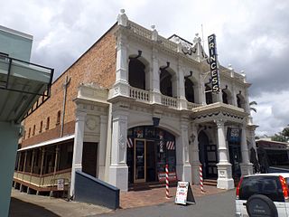
Princess Theatre is a heritage-listed theatre at 8 Annerley Road, Woolloongabba, Queensland, Australia. It was designed by architect John Beauchamp Nicholson and built in 1888. It is also known as South Brisbane Public Hall and Boggo Road Theatre. It was added to the Queensland Heritage Register on 21 October 1992.

Annerley Road is an arterial road in Brisbane, Queensland, Australia. It was formerly known as Boggo Road.

Taylor–Heaslop Building commercial building in City of Brisbane

Taylor–Heaslop Building is a heritage-listed commercial building at 10-14 Logan Road, Woolloongabba, City of Brisbane, Queensland, Australia. It was designed by John Beauchamp Nicholson and built from 1889 to 1890. It is also known as Ernest Reid (draper), John Evan's Cash Draper, George Logan Draper, Johns & Co Draper, People's Cash Store (grocers), JR Blane, and Moreton Rubber Works. It was added to the Queensland Heritage Register on 6 February 2006.
Woolloongabba Fiveways

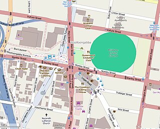
The Woolloongabba Fiveways is the intersection of 5 major roads at Woolloongabba, Brisbane, Queensland, Australia. The intersection gives its name to the surrounding commercial area.

Clarence Corner, Woolloongabba Road intersection in Brisbane, Queensland

Clarence Corner is the junction of Stanley Street and Annerley Road in Woolloongabba/South Brisbane in Brisbane, Queensland, Australia. It gives its name to the local area.

Pollocks Shop House

Pollock's Shop House is a heritage-listed general store at 617-619 Stanley Street, Woolloongabba, City of Brisbane, Queensland, Australia. It was built c. 1865. It was added to the Queensland Heritage Register on 21 October 1992.

References

  1. "Broadway Hotel (entry 600354)". Queensland Heritage Register . Queensland Heritage Council. Retrieved 13 September 2011.
  2. Google (20 July 2017). "Stanley Street, Brisbane" (Map). Google Maps . Google. Retrieved 20 July 2017.