Gympie Road, Brisbane

Last updated

Gympie Road

Gympie Road Chermside 2008.JPG
Gympie Road, Brisbane
General information
Type Road
Length19 km (12 mi)
Route number(s)
  • AUS Alphanumeric Route A3.svg A3
  • (Lutwyche to Bald Hills)
  • Australian state route 58.svg State Route 58

(Bald Hills to Petrie)

Major junctions
SE endAUS Alphanumeric Route A3.svg Lutwyche Road, Lutwyche, Queensland
 AUS Alphanumeric Route M3.svg Gympie Arterial Road
NW endAustralian state route 58.svg Dayboro Road, Petrie, Queensland
Location(s)
Major suburbs Kedron, Chermside, Aspley, Strathpine
Gympie Road, Kedron 2008 Gympie Road Kedron 2008.JPG
Gympie Road, Kedron 2008

Gympie Road is a major road in the northern suburbs of Brisbane, Queensland, Australia. The road forms part of the main road route from the Brisbane Central Business District (CBD) to the northern suburbs, Sunshine Coast and east coast of Queensland.

Contents

Gympie Road is designated A3 from Lutwyche Road, Kedron to the Gympie Arterial Road, Bald Hills. The road then continues as State Route 58 to Dayboro Road, Petrie.

Gympie Road is named after the town of Gympie, north of the Sunshine Coast.

Landmarks

Gympie Road is lined with many shops, fast food outlets, restaurants, car yards, factories, motels, caravan parks, parks and schools including:

History

Cobb and Co coach, Old Gympie Road, Kallangur Cobb and Co coach, Old Gympie Road, Kallangur.jpg
Cobb and Co coach, Old Gympie Road, Kallangur

The first private land sale occurred on Gympie Road near Kedron Brook in 1857. Farms, slaughter yards [2] and tanneries [3] were common sights along Gympie Road prior to World War I.

The tram line from the Brisbane CBD was extended to Kedron Park Hotel in 1914, Lutwyche Cemetery in 1925 and Chermside in 1947. [4] The tram service was closed in 1968 and replaced with diesel buses.

In 1922, there was a proposal to build Anzac Avenue as a memorial to those who died in World War I. The memorial avenue was to run from Brisbane CBD to Redcliffe (which, at that time, was not connected to Brisbane by road, only by sea). This proposal would use and rename Gympie Road for the northward part of the route and then extend it eastwards towards Redcliffe. However, in its final form, Anzac Avenue commenced at Petrie rather than Brisbane and so Gympie Road was only renamed from Petrie onwards (which is why Gympie Road terminates at Petrie today). The first segment of Anzac Avenue from Petrie to Kallangur was formerly Gympie Road. However, at Kallangur, Anzac Avenue left Gympie Road to go east, leaving parts of Gympie Road going north through Kallangur to Burpengary disconnected (as a name) from the Brisbane to Petrie section. The segment from Kallangur to Burpengary was later renamed Old Gympie Road.

The first integrated shopping mall in Queensland opened on the corner of Gympie Road and Hamilton Road, Chermside in 1957. Originally called the Chermside Drive-in Shopping Centre, it has extended on many occasions and is now Westfield Chermside.

The route was formerly part of the Bruce Highway and carried the designation National Route 1 until the Gateway Bridge opened in 1986. The route has since had the designations of Alt Route 1 and Metroad 3.

Future

TransLink is planning for the Kedron to Bracken Ridge section of the Northern Busway that will generally follow Gympie Road.

Gympie Road has the following interfaces with the Airport Link tunnel:

Major intersections

LGALocationkmmiDestinationsNotes
Brisbane Kedron 00.0AUS Alphanumeric Route A3.svg Lutwyche Road (State Route A3) south - Lutwyche /
Kedron Park Road - east - Wooloowin /
AUS Alphanumeric Route M7.svg Airport Link (State Route M7) east - Hendra, Brisbane Airport
Southern end of Gympie Road (A3)
Traffic proceeding north from Lutwyche Road and wishing to travel east on Airport Link can cross the southbound carriageway of Gympie Road under traffic light control and exit at this intersection.
Kedron Brook 0.20.12Bridge (no known official name)
Brisbane Kedron 0.40.25AUS Metroad 5.svg Stafford Road (Metroad 5) west - Stafford This is a grade-separated intersection.
0.50.31AUS Alphanumeric Route M7.svg Airport Link (State Route M7) east - Hendra, Brisbane Airport /
south - Windsor, Bowen Hills
Traffic proceeding south on Gympie Road and wishing to travel in either direction on Airport Link can exit Gympie Road at this point.
0.60.37AUS Alphanumeric Route M7.svg Airport Link (State Route M7)Traffic from either direction exiting the Airport Link can enter the northbound carriageway of Gympie Road at this point.
1.71.1Edinburgh Castle Road - east - Wavell Heights
1.91.2Kitchener Road - west - Stafford Heights
Chermside 2.61.6Rode Road - west - Chermside West /
east - Wavell Heights
3.52.2Hamilton Road - west - Chermside West /
east - Wavell Heights
Downfall Creek4.12.5Bridge (no known official name)
Brisbane Chermside - Aspley boundary4.22.6Murphy Road - north-east - Zillmere Intersection is on the boundary between Chermside and Aspley, which follows the centre line of Gympie Road to the north-west and that of Murphy Road to the north-east.
5.13.2Australian state route 27.svg Webster Road (State Route 27) south - Chermside West /
Australian state route 27.svg Ellison Road (State Route 27) east - Geebung
Intersection is on the boundary between Chermside and Aspley, which follows the centre line of Gympie Road to the south-east and that of Webster Road to the south.
Aspley 6.44.0Australian state route 28.svg Albany Creek Road (State Route 28) west - Bridgeman Downs, Albany Creek /
Australian state route 28.svg Robinson Road West (State Route 28) east - Geebung
7.34.5Zillmere Road - east - Zillmere
Cabbage Tree Creek (formerly Tighgum Creek)7.34.5Bridge (no known official name)
Brisbane Carseldine 7.44.6Graham Road - west - Bridgeman Downs
8.55.3Beams Road - west - Bridgeman Downs /
east - Fitzgibbon
9.45.8AUS Alphanumeric Route M3.svg Gympie Arterial Road (State Route M3) north - Bald Hills This intersection allows traffic to exit from the northbound carriageway of the highway to the Sunshine Coast, which becomes Gympie Arterial Road, and to continue to follow Gympie Road. There is no access to either side of the highway at this intersection.
Carseldine - Bald Hills boundary10.26.3Australian state route 40.svg Linkfield Road (State Route 40) west - Brendale /
east - Bracken Ridge
Intersection is on the boundary between Carseldine and Bald Hills, which follows the centre line of Linkfield Road.
Bald Hills 12.07.5Australian state route 58.svg Strathpine Road (State Route 58) east - Bracken RidgeGympie Road continues west as State Route 58.
South Pine River 12.27.6Bridge (no known official name)
Moreton Bay Strathpine 13.08.1Kremzow Road - south - Brendale
13.58.4Australian state route 28.svg South Pine Road (State Route 28) west - Brendale
14.79.1Samsonvale Road - west - Bray Park /
Bells Pocket Road - east - Lawnton
Four Mile Creek15.39.5Bridge (no known official name)
Moreton Bay Lawnton 16.510.3Francis Road - west - Joyner
16.810.4Todds Road - west - Joyner /
Lawnton Pocket Road - east - Lawnton
North Pine River 17.811.1A.J.Wyllie [5] Bridge
Moreton Bay Petrie 18.511.5Australian state route 58.svgDayboro Road (State Route 58) west - Whiteside /
Australian state route 71.svg Anzac Avenue (State Route 71) east - Kallangur
Northern end of Gympie Road.

See also

Australia road sign W5-29.svg   Australian Roadsportal

Related Research Articles

Bruce Highway

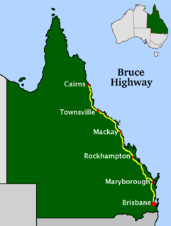
The Bruce Highway is a major highway in Queensland, Australia. Commencing in the state capital, Brisbane, it passes through areas close to the eastern coast on its way to Cairns in Far North Queensland. The route is part of the Australian National Highway and also part of Highway 1, the longest highway route in Australia. Its length is approximately 1,679 kilometres (1,043 mi); it is entirely sealed with bitumen. The highway is named after a popular former Queensland and federal politician, Harry Bruce. Bruce was the state Minister for Works in the mid-1930s when the highway was named after him. The highway once passed through Brisbane, but was truncated at Bald Hills when the Gateway Motorway became National Highway 1 upon its opening in December 1986.

Aspley, Queensland Suburb of Brisbane, Queensland, Australia

Aspley is a suburb in the City of Brisbane, Queensland, Australia. In the 2016 census, Aspley had a population of 12,108 people.

Chermside, Queensland Suburb of Brisbane, Queensland, Australia

Chermside is a major suburb of the City of Brisbane, Queensland, Australia. The suburb is situated just 9 km north of the city and is one of Brisbane's fastest developing suburbs. Chermside is known as a mini CBD of Brisbane. It is home to the largest Westfield shopping centre in Australia.

Gordon Park, Queensland Suburb of Brisbane, Queensland, Australia

Gordon Park is a northern suburb in the City of Brisbane, Queensland, Australia. In the 2016 census, Gordon Park had a population of 4,231 people.

Shire of Pine Rivers Local government area in Queensland, Australia

The Shire of Pine Rivers was a local government area about 20 kilometres (12 mi) north of Brisbane in the Moreton Bay region of South East Queensland, Australia. The shire covered an area of 771 square kilometres (297.7 sq mi), and existed as a local government entity from 1888 until 2008, when it amalgamated with councils further north to form the Moreton Bay Region.

The Northern Busway is a bus-only road running north from the Brisbane central business district to the Royal Brisbane & Women's Hospital in Queensland, Australia. The first section of the busway opened on 23 February 2004 with one station at QUT Kelvin Grove. In December 2005, Normanby and Herston stations opened.

Petrie, Queensland Suburb of Moreton Bay, Queensland, Australia

Petrie is a suburb in the Moreton Bay Region, Queensland, Australia.

Lutwyche, Queensland Suburb of Brisbane, Queensland, Australia

Lutwyche is an inner-city residential suburb of the City of Brisbane, Queensland, Australia, located 5 kilometres (3.1 mi) north of the city's central business district. At the 2016 census the suburb recorded a population of 3,454.

Kedron is a northern suburb of Brisbane, Queensland, Australia.

Stafford, Queensland Suburb of Brisbane, Queensland, Australia

Stafford is a northern suburb of the City of Brisbane, the state capital of Queensland, Australia.

Strathpine, Queensland Suburb of Moreton Bay Region, Queensland, Australia

Strathpine is a suburb in the Moreton Bay Region, Queensland, Australia. It is home to the Pine Rivers District offices of the Moreton Bay Region as well as many businesses. The area is home to Strathpine Centre, a medium-sized urban shopping centre.

Kallangur, Queensland Suburb of Moreton Bay Region, Queensland, Australia

Kallangur is a suburb in Moreton Bay Region, Queensland, Australia. It is north of Brisbane, the state capital. At the 2016 Australian Census, the suburb recorded a population of 20,405. A section of the Bruce Highway marks the eastern boundary.


The (M3/A3) in Brisbane, Queensland, Australia, is a major urban road corridor. It connects Eight Mile Plains to Bald Hills via the following corridors:

The M1 in, Queensland, Australia, is a major urban road corridor. It connects the Sunshine Coast hinterland to Tugun, near the New South Wales-Queensland border, via the following corridors:

Kalinga Park

Kalinga Park is a heritage-listed park at 100 Bertha Street, Kalinga, City of Brisbane, Queensland, Australia. The eastern section of the park is in neighbouring Clayfield. It is also known as Anzac Memorial Park. It was added to the Queensland Heritage Register on 3 July 2007.

Enoggera, Queensland Suburb of Brisbane, Queensland, Australia

Enoggera is a suburb of the City of Brisbane, in Queensland, Australia.

Sandgate Road

Sandgate Road is a major road in Brisbane, Queensland, Australia. It provides part of the road connection between Redcliffe and the Brisbane CBD. It is designated state route 26 throughout most of its length.

Anzac Avenue

Anzac Avenue is a heritage-listed major arterial road lined with trees in the Moreton Bay Region, Queensland, Australia. It runs 17.8 kilometres (11.1 mi) from Petrie to Redcliffe, with most of the route signed as state route 71. The route was formerly the main route to the Redcliffe peninsula, until the Hornibrook Bridge was built.

Busways in Brisbane

Since the mid-1990s, a 27 kilometre bus rapid transit network has been developed in Brisbane, Australia. It comprises grade-separated bus-only corridors, complementing the Queensland Rail City network. Management of the busway network is the responsibility of TransLink as coordinator of South East Queensland's integrated public transport system.

References

  1. "Pine Rivers Park". moretonbay.qld.gov.au. Moreton Bay Regional Council. Archived from the original on 24 October 2017. Retrieved 24 October 2017.
  2. "Noxious Industry to Parks and Houses". chermsidedistrict.org.au. Chermside and District Historical Society. Archived from the original on 25 October 2017. Retrieved 25 October 2017.
  3. "Packer and Knox". chermsidedistrict.org.au. Chermside and District Historical Society. Archived from the original on 25 October 2017. Retrieved 25 October 2017.
  4. "Trams to Chermside". chermsidedistrict.org.au. Chermside and District Historical Society. Archived from the original on 25 October 2017. Retrieved 25 October 2017.
  5. "Wyllie Homestead Gate Posts". North Pine Historical Society Inc. Archived from the original on 8 May 2014. Retrieved 8 May 2014.

Coordinates: 27°23′44.80″S153°01′51.72″E / 27.3957778°S 153.0310333°E / -27.3957778; 153.0310333