
Mount Cotton is a rural locality in the City of Redland, Queensland, Australia. In the 2021 census, Mount Cotton had a population of 7,302 people.
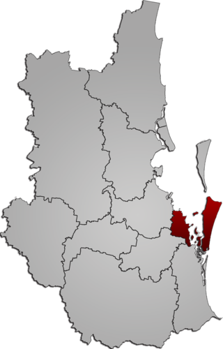
Redland City, also known as the Redlands and formerly known as Redland Shire, is a local government area (LGA) and a part of Greater Brisbane in South East Queensland, Australia. With a population of 159,222 as of June 2021, Redland City is spread along the southern coast of Moreton Bay, covering 537.2 square kilometres (207.4 sq mi). The city borders the City of Brisbane to the west and north-west and Logan City to the south-west and south, while its islands are situated north of the City of Gold Coast.
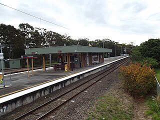
Thorneside railway station is located on the Cleveland line in Queensland, Australia. It serves the suburb of Thorneside in Redland City.

Capalaba is an urban locality in the City of Redland, Queensland, Australia. In the 2021 census, Capalaba had a population of 18,002 people.

Tingalpa is a suburb in the City of Brisbane, Queensland, Australia. In the 2021 census, Tingalpa had a population of 8,461 people.
The Gateway Motorway is a major tolled motorway in Brisbane, Queensland, Australia which includes the Sir Leo Hielscher Bridges. The motorway is operated by toll road operator Transurban.

The Leslie Harrison Dam is an earth-fill embankment dam across the Tingalpa Creek that is located in the South East region of Queensland, Australia. The main purpose of the dam is for potable water supply of the Redland City in Brisbane. The impounded reservoir is called Tingalpa Reservoir. The dam was named after Robert Leslie Harrison, a Queensland parliamentarian who died in April 1966.

Burbank is a greenbelt suburb in the City of Brisbane, Queensland, Australia. In the 2021 census, Burbank had a population of 1,051 people.

Redland Bay is a coastal semi-rural locality in the City of Redland, Queensland, Australia. In the 2021 census, Redland Bay had a population of 17,056 people.
The M1 in Queensland, Australia, is a major urban road corridor. It connects the Sunshine Coast hinterland to Tugun, near the New South Wales and Queensland border, via the following corridors:
Carbrook is a suburb in the City of Logan, Queensland, Australia. Carbrook was previously called Gramzow, a name of German origin. The German name was anglicised in 1916 during World War I. In the 2021 census, Carbrook had a population of 1,330 people.

Chandler is an outer south-eastern suburb in the City of Brisbane, Queensland, Australia. In the 2021 census, Chandler had a population of 1,475 people.

Sheldon is a rural residential locality in the City of Redland, Queensland, Australia. In the 2021 census, Sheldon had a population of 1,762 people.

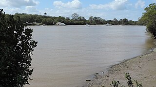
Tingalpa Creek is a creek in South East Queensland. It flows along Brisbane's south east boundary with Redland City Council. On early maps the creek was called both Tunim Creek and Tangulba Creek.
The Shire of Tingalpa was a local government area in the south-eastern suburbs of Brisbane, Queensland, Australia. The shire, administered from Mount Cotton, covered an area of 120 square miles (311 km2), and existed as a local government entity from 1879 until 1949.

Old Cleveland Road is a major road in Brisbane, Queensland. It runs 19.3 kilometres (12.0 mi) from Stones Corner to Capalaba in Brisbane, with most of the route signed as State Route 22. Sections of the road are also part of State Routes 30, 54, and 55. The road is the main route from inner Brisbane to Capalaba and Cleveland since New Cleveland Road only links Tingalpa with Capalaba.

Carbrook Lutheran Cemetery is a heritage-listed cemetery at Mount Cotton Road, Carbrook, City of Logan, Queensland, Australia. It was built from c. 1875 onwards. It is also known as St Paul's Lutheran Church. It was added to the Queensland Heritage Register on 4 August 1997.

Serpentine Creek Road Cemetery is a heritage-listed cemetery at 398-408 Serpentine Creek Road, Redland Bay, Redland City, Queensland, Australia. It was established in 1890 and operated until 1945. It is also known as Redland Bay Cemetery and South Redland Bay Cemetery. It was added to the Queensland Heritage Register on 6 January 1999.
Beenleigh–Redland Bay Road is a continuous 16.5 kilometres (10.3 mi) road route in the Logan and Redland local government areas of Queensland, Australia. The route is designated as part of State Route 47. It is a state-controlled district road rated as a local road of regional significance (LRRS).
Cleveland–Redland Bay Road is a continuous 15.2 kilometres (9.4 mi) road route in the Redland local government area of Queensland, Australia. The route is designated as part of State Route 47. It is a state-controlled district road rated as a local road of regional significance (LRRS).


