Road transport in Brisbane

Last updated

The Pacific Motorway links Brisbane and the Gold Coast (2006) Southeast freeway.jpg
The Pacific Motorway links Brisbane and the Gold Coast (2006)
The Airport Flyover alleviated a congestion black spot Airport Flyover, Brisbane.JPG
The Airport Flyover alleviated a congestion black spot
Ipswich Road becomes the Ipswich Motorway and links Brisbane to Ipswich, 2010 Ipswich Road.jpg
Ipswich Road becomes the Ipswich Motorway and links Brisbane to Ipswich, 2010

The road transport in Brisbane, Australia, consists of a network of highways, freeways and motorways. Some motorways have tolls applied.

Contents

Brisbane is a car dependent city. In 2006, within the South East Queensland region, 83% of trips were done by car. [1]

Brisbane is linked with both the Gold Coast and Sunshine Coast by freeway-led suburbanisation. [2]

Network

The Brisbane River has created a barrier to some road transport routes. In total there are nine road bridges and one road tunnel, mostly concentrated in the inner city area. This has intensified the need for transport routes to focus on the inner city. One more cross-river tunnel is planned (East-West Link) as part of the TransApex plan.

Brisbane's road system was planned around large, spacious suburban areas. Dense suburbs now rely on several main road corridors that split through and between these areas and provide the only link to the CBD and other areas of Brisbane. Logan Road, Moggill Road, Old Cleveland Road and Gympie Road are but a few of these multi-lane corridors that come out of the CBD and snake through the suburbs.

Bypasses such as the Inner City Bypass, Airport Link and Clem Jones Tunnel are intended to help to circulate traffic away from the inner-city areas and main roads via limited-access roads above the ground, and tunnels below that have higher speed limits and exits to particular suburbs.

Existing high speed cross-suburban motorways such as the Western Freeway, Centenary Motorway, Pacific Motorway and Gateway Motorway provide alternative routes to main roads and connect up to main highways and other arterial roads. The TransApex plan tunnels, Airport Link tunnel and Clem Jones Tunnel, Legacy Way tunnel and East-West Link tunnel are designed to link all the various motorways in Brisbane together. Only East-West link is yet to commence planning or construction.

In total, the twisting Brisbane River is crossed by nine road bridges, one road tunnel, three railway bridges, three dedicated cyclist/pedestrian bridges and one dedicated bus/cycle/pedestrian bridge. Route signage is achieved by means of a system of Metroads, consisting of the most important arterial roads in metropolitan Brisbane including most motorways, and less important State Routes; however, in recent years, the Metroads are being superseded by an alphanumeric numbering system. Multiple freeways connect Brisbane to other cities, including the Pacific Motorway, the Bruce Highway and the Ipswich Motorway, all of which are part of the National Highway System. Brisbane is approximately 1,000 kilometres (620 mi) away from Sydney, the closest major capital city.

An upgrade to Brisbane's traffic lights system began in April 2011. [3] The old system was called Brisbane Linked Intersection Signal System (BLISS) and required a controller to trigger traffic lights to relieve congestion. The new system called Sydney Coordinated Adaptive Traffic System (SCATS) is used in every other Australian capital city and is expected to cost much less to maintain. All 850 sets of Brisbane City Council signal boxes require upgrades. [3]

Six major roads and bridges in Brisbane are tolled, with all of them using free-flow tolling technology. [4]

The north-west of the city lacks a major roadway. A Brisbane City Council investigation revealed the northside’s urban routes were not designed for the traffic volumes they were experiencing in 2020. [5] Without the development of the North West Transport Corridor rapid population growth north of the city generates traffic congestion and is expected to lead to overcrowding on buses. [6]

Motorways

Brisbane is served by several motorways. The Pacific Motorway connects the central city with the Gold Coast to the south. The Ipswich Motorway connects the city with Ipswich to the west via the southern suburbs, while the Western Freeway and the Centenary Motorway provide a connection between Brisbane's inner-west and the outer south-west, connecting with the Ipswich Motorway south of the Brisbane River. The Bruce Highway is Brisbane's main route north of the city to the rest of the State. The Bruce Highway terminates 1,700 kilometres (1,100 mi) away in Cairns and passes through most major cities along the Queensland coast.

The Gateway Motorway connects the Gold Coast and Sunshine Coasts by providing an alternate eastern route avoiding Brisbane's inner city area, connecting the Bruce Highway to the Pacific Motorway, and by linking to the Logan Motorway (albeit tolled) it forms part of an incomplete ring road. It crosses the Brisbane River over the tolled Sir Leo Hielscher Bridges. The Port of Brisbane Motorway links the Gateway to the Port of Brisbane, while Inner City Bypass and the Riverside Expressway act as the inner ring freeway system to prevent motorists from travelling through the city's congested centre. [7]

Road NumberMotorway/HighwayDestination
AUS Alphanumeric Route M3.svgAUS Alphanumeric Route M1.svgM3/M1 Gympie Arterial Road / Bruce Highway Carseldine (Gympie Road) – Bald Hills (M1 Gateway Gympie Arterial Interchange) – Pine River (Bruce Highway terminus) – CabooltureNambourCooroy – (Northern Regional Centres)
AUS Alphanumeric Route M1.svgAUS Alphanumeric Route M1 toll.svgAUS Alphanumeric Route M2 toll.svgM1/M2 Gateway Motorway TOLL ROAD [lower-alpha 1] Drewvale (M2 Gateway Logan Int.) – Eight Mile Plains (M1 Gateway Pacific Int.) – Murarrie (Port of Brisbane Mwy Int.) – Gateway BridgeBald Hills (M3 Gateway Gympie Arterial Int.)
AUS Alphanumeric Route M1.svgAUS Alphanumeric Route M3.svgM1/M3 Pacific Motorway Inner City BypassEight Mile Plains (M1 Gateway Pacific Interchange) – Loganholme (Logan Pacific Int.) – Helensvale (Gold Coast Int.) – Tugun Bypass – (NSW)
AUS Alphanumeric Route M2.svgAUS Alphanumeric Route M7.svgM2/M7 Ipswich Motorway Dinmore (Warrego Cunningham Interchange) – Gailes (Ipswich Logan Interchange) – Darra (Centenary Roundabout Interchange) – Rocklea (Granard / Ipswich Roads)
AUS Alphanumeric Route M2 toll.svgM2 Logan Motorway TOLL ROAD Gailes (Ipswich Logan Int.) – Forest Lake (Logan Centenary Int.) – Greenbank (Logan Lindsay Highway Int.) – Drewvale (Gateway Logan Int.) – Loganholme (Logan Pacific Int.)
AUS Alphanumeric Route M5.svgAUS Alphanumeric Route A5.svgM5/A5 Centenary Motorway / Western Freeway Springfield LakesForest Lake (Logan Centenary Interchange) – Darra (Centenary Roundabout Interchange) – IndooroopillyToowong Roundabout (Milton Road)
Australian national route 13.svgNational Route 13 Mount Lindesay Highway MoorookaGreenbank (Logan Lindsay Int.) – Browns PlainsJimboombaBeaudesertRathdowney Woodenbong, NSW (Summerland Way) – Tenterfield, NSW (New England Highway)
AUS Alphanumeric Route M3.svgM3 Inner City Bypass Kelvin Grove (Pacific Motorway) – Bowen Hills (CLEM7 Int.) – Albion (Kingsford Smith Drive)
AUS Alphanumeric Route M7 toll.svgM7 Clem Jones Tunnel TOLL ROAD Woolloongabba (Pacific CLEM7 Interchange) – Bowen Hills (Inner City Bypass Int.)
AUS Alphanumeric Route M4.svgM4 Port of Brisbane Motorway Murarrie (Gateway Interchange) – Lytton
AUS Alphanumeric Route M7 toll.svgM7 Airport Link TOLL ROAD (completed 2011/12) Bowen Hills (CLEM7/ICB Interchange) – LutwycheToombul
AUS Alphanumeric Route M15.svgAUS Alphanumeric Route A15.svgM15/A15 Cunningham Highway Dinmore (Warrego Cunningham Interchange) – YamantoWarwick – (South Western Regional Centres)
AUS Alphanumeric Route M2.svgAUS Alphanumeric Route A2.svgM2/A2 Warrego Highway Dinmore (Warrego Cunningham Int.) – Brassall (Brisbane Valley Hwy Int.) – GattonToowoomba Bypass – (Western Regional Centres)
Australian state route 26.svgState Route 26 Houghton Highway / Deagon Deviation Clontarf (Redcliffe) – BrightonGateway Motorway
Australian state route 85.svgState Route 85 D'Aguilar Highway Caboolture (Bruce Highway Interchange) – KilcoyNanango
  1. Note that only the Gateway Bridges and the Gateway Motorway from Eight Mile Planes to Drewvale is a toll road

Route numbering

The Brisbane system of road routes is numbered mostly separately to the rest of the state, and the systems on the Gold Coast and Sunshine Coast. The route numbering is basically distributed as so (with a few exceptions):

Routes 1–6, 13 & 15: Major highways and motorways
10, 20, 30, 40 & 50: Orbitals (all incomplete)
21–29, 41–48: Eastern Brisbane
31–39: Western Brisbane
90–99: Southern Brisbane and Gold Coast

Due to the introduction of Metroads in the early 1990s, a few routes around the city are split up. Routes Australian state route 20.svg and Australian state route 22.svg are examples of routes which were formerly continuous, but have been superseded by Metroads or M routes.

Management

Traffic in Brisbane metropolitan area is managed by the Brisbane Metropolitan Traffic Management Centre. It operates non-stop, provides a phone hotline and a website which provides traffic and travel information. [8]

Current infrastructure projects

Driving

Brisbane drivers, like all of Queensland, are not permitted to hold a mobile phone while driving, even if it is switched off. [10]

See also

Related Research Articles

<span class="mw-page-title-main">Rush hour</span> Time of day with peak traffic congestion

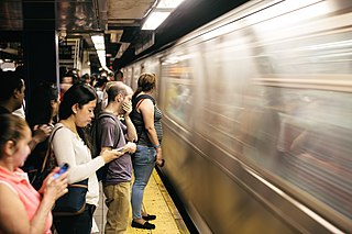
A rush hour or peak hour is a part of the day during which traffic congestion on roads and crowding on public transport is at its highest. Normally, this happens twice every weekday: once in the morning and once in the afternoon or evening, the times during which most people commute. The term is often used for a period of peak congestion that may last for more than one hour.

Metroads were the primary road routes serving the Sydney and Brisbane metropolitan areas from the 1990s to the early 2010s. The Metroads formed a network of radial and circumferential routes throughout the cities, simplifying navigation. Metroads have been progressively phased out in both Sydney and Brisbane, replaced by alphanumeric route numbers. Brisbane is the only city currently retaining the Metroad system.

<span class="mw-page-title-main">Pacific Motorway (Brisbane–Brunswick Heads)</span> Motorway in New South Wales and Queensland

The Pacific Motorway is a motorway in Australia between Brisbane, Queensland, and Brunswick Heads, New South Wales, through the New South Wales–Queensland border at Tweed Heads.

<span class="mw-page-title-main">Pacific Motorway (Sydney–Newcastle)</span> Motorway in New South Wales, Australia

The M1 Pacific Motorway is a 127-kilometre motorway linking Sydney to Newcastle via the Central Coast and Hunter regions of New South Wales. Formerly known but still commonly referred to by both the public and the government as the F3 Freeway, Sydney–Newcastle Freeway, and Sydney–Newcastle Expressway, it is part of the AusLink road corridor between Sydney and Brisbane. The name "F3 Freeway" reflects its former route allocation before it was decommissioned and replaced by the rollout of alphanumeric signposts.

The Gateway Motorway is a major tolled motorway in Brisbane, Queensland, Australia which includes the Sir Leo Hielscher Bridges. The motorway is operated by toll road operator Transurban.

<span class="mw-page-title-main">Logan Motorway</span> Motorway in Queensland, Australia

The M2/M6 Logan Motorway is a 30-kilometre toll road between Ipswich and the M1 or Pacific Motorway at Loganholme, and the Gateway Motorway, providing access to the Gold Coast on the eastern seaboard and to the rural areas of the Darling Downs to the west. The M6 portion runs from the Pacific Motorway to the junction with the Gateway Motorway at Drewvale, where it then becomes the M2, continuing on to merge with the Ipswich Motorway at Gailes.

<span class="mw-page-title-main">Warringah Freeway</span> Freeway in Sydney, Australia

Warringah Freeway is a 3.5-kilometre (2.2 mi) divided freeway in Sydney, New South Wales that is part of the Sydney Orbital Network. The primary function of the freeway is to provide an alternative high-grade route from the Sydney Harbour Tunnel and Bradfield Highway at Milsons Point to the A8 and Gore Hill Freeway. The freeway reduces traffic demands on Pacific Highway throughout Sydney's Lower North Shore, bypassing North Sydney and Crows Nest, and provides a vital link to access most of the suburbs in Sydney and is also a major route to the north, south, east and west of the central business district.

TransApex was a road transport plan devised by Brisbane Lord Mayor Campbell Newman in the early 2000s to connect existing motorways and major arterial roads with new transport links and divert cross-city traffic out of the Brisbane central business district. The plan is currently being delivered by Brisbane City Council at an estimated total cost of over $10 billion across five stages. According to the Brisbane City Council website, TransApex is "the biggest urban road project proposed in Australia".

<span class="mw-page-title-main">M2 Hills Motorway</span> Motorway in Sydney, Australia

M2 Hills Motorway is a 19.3-kilometre (12.0 mi) tolled urban motorway in Sydney, New South Wales that is part of the Sydney Orbital Network and the National Highway west of Pennant Hills Road. Owned by toll road operator Transurban, it forms majority of Sydney's M2 route, with the Lane Cove Tunnel constituting the rest of the M2 route.

<span class="mw-page-title-main">M4 Motorway (Sydney)</span> Motorway in Sydney

The M4 Motorway is a 52.6-kilometre (32.7 mi) partially tolled dual carriageway motorway in Sydney, New South Wales that is designated the M4 route marker. The M4 designation is part of the wider A4 and M4 route designation, the M4 runs parallel/below ground to the Great Western Highway and Parramatta Road (A44).

<span class="mw-page-title-main">M5 Motorway (Sydney)</span> Motorway in Sydney, Australia

The M5 Motorway is a 29-kilometre (18 mi) motorway located in Sydney, New South Wales that is part of the Sydney Orbital Network.

The M1 in, Queensland, Australia, is a major urban road corridor. It connects the Sunshine Coast hinterland to Tugun, near the New South Wales and Queensland border, via the following corridors:

<span class="mw-page-title-main">Transport in Brisbane</span>

Transport in Brisbane, the capital and largest city of Queensland, Australia, is provided by road, rail, river and bay ferries, footpaths, bike paths, sea and air.

<span class="mw-page-title-main">Western Distributor (Sydney)</span> Motorway in New South Wales, Australia

Western Distributor is a 4.3-kilometre-long (2.7 mi) grade-separated motorway that is primarily elevated for the majority of its route on the western fringe of the Sydney central business district in New South Wales, Australia. It links the southern end of Bradfield Highway at the Sydney Harbour Bridge to Victoria Road in Rozelle, at its western terminus near White Bay. It is a constituent part of the A4 route.

<span class="mw-page-title-main">A8 (Sydney)</span> Road in New South Wales, Australia

The A8 is a route designation of a major metropolitan arterial route through suburban north-eastern Sydney. This name covers a few consecutive roads and is widely known to most drivers, but the entire allocation is also known – and signposted – by the names of its constituent parts: Pittwater Road, Condamine Street, Burnt Bridge Creek Deviation, Manly Road, Spit Road and Military Road.

<span class="mw-page-title-main">Toll roads in Australia</span> Overview of toll roads in Australia

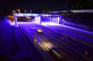
Australian toll roads are found in the eastern states of New South Wales, Victoria and Queensland. Most of the toll roads are within the urban limits of Sydney, Melbourne and Brisbane, with the exception of the Toowoomba Bypass in Toowoomba.

East-West Link is a proposed road tunnel in Brisbane, Queensland, Australia. It forms the fifth and final component of Brisbane City Council's TransApex plan to connect motorways across the city, construct new river crossings and divert cross-city traffic out of the Brisbane CBD.

References

  1. Bridie Jabour (19 September 2011). "Tolls the price to pay for roads". Brisbane Times . Fairfax Media. Retrieved 28 July 2012.
  2. Spearritt, Peter (March 2009). "The 200 Km City: Brisbane, The Gold Coast, And Sunshine Coast". Australian Economic History Review . 49 (1): 88. doi: 10.1111/j.1467-8446.2009.00251.x .
  3. 1 2 Tony Moore (6 April 2011). "Autoflush for Brisbane traffic". Brisbane Times . Fairfax Media. Retrieved 4 May 2011.
  4. "Tollways and tolling". Department of Transport and Main Roads. 24 May 2012. Retrieved 28 July 2012.
  5. Johnstone, Craig (3 December 2020). "Council ponders new Brisbane motorway as congestion costs soar". InQueensland. Retrieved 19 November 2021.
  6. Stone, Lucy (2 February 2021). "North West Transport Corridor plans dusted-off as Brisbane tackles congestion in the suburbs". ABC News . Australian Broadcasting Corporation . Retrieved 15 November 2021.
  7. "The upgrade". Gateway Upgrade Project. Archived from the original on 6 July 2011. Retrieved 5 January 2008.
  8. "Brisbane's Metropolitan Traffic Incident Management Services". Department of Transport and Main Roads. 5 October 2010. Retrieved 28 July 2012.
  9. Tony Moore (2 September 2011). "Work on horror intersection starts before Christmas". Brisbane Times . Fairfax Media. Retrieved 28 July 2012.
  10. Khan, Nibir (31 October 2021). "Queensland drivers caught without seatbelts or using phones hit with new fines from tomorrow". ABC News . Australian Broadcasting Corporation . Retrieved 31 October 2021.