Brassall, Queensland

Last updated

Brassall
Ipswich,  Queensland
Welcome to Ipswich - panoramio (1).jpg
Signage on Pine Mountain Road, 2010
Australia Queensland location map.svg
Red pog.svg
Brassall
Coordinates 27°35′30″S152°44′07″E / 27.5916°S 152.7352°E / -27.5916; 152.7352 (Brassall (centre of suburb))
Population12,115 (SAL 2021) [1]
Postcode(s) 4305
Area8.2 km2 (3.2 sq mi)
Time zone AEST (UTC+10:00)
Location
LGA(s) City of Ipswich
State electorate(s) Ipswich West
Federal division(s) Blair
Suburbs around Brassall:
Pine Mountain Muirlea North Ipswich
Karrabin
Blacksoil
Brassall North Ipswich
Wulkuraka Coalfalls Woodend

Brassall is a suburb in the City of Ipswich, Queensland, Australia. [2] As of the 2021 census, Brassall had a population of 12,115 people. [3]

Contents

Geography

Brassall has a southern boundary partially marked by the Bremer River and a western alignment along Ironpot Creek. The northern boundary follows the Warrego Highway. [4] Brassall now incorporates part of the old suburb of Raymond Hill. Ipswich–Warrego Highway Connection Road is the main road through the suburb. It runs through from east to north. [5]

History

2010-11 Queensland floods in Brassall streets A flooded street in Brassall, Ipswich 3.jpg
2010–11 Queensland floods in Brassall streets

The suburb name first appears on a plan drawn by surveyor James Warner on 6 October 1851; however, the origin of the suburb name is unknown. [2] It was also known as Hungry Flats, as was a stop over for bullock teams that were transporting logs from Pine Mountain to Hancocks saw mill at North Ipswich. [6]

Brassall was a separate shire (Shire of Brassall) with its own council from March 1860 until 1 January 1917 when the area became part of the City of Ipswich.

The Brisbane Valley railway line passed through Brassall. The line opened from Ipswich to Lowood on 16 June 1884, and was extended through a number of stages until it reached Yarraman on 1 May 1913. The line closed in 1993. The disused rail corridor was used to construct the Brassall Bikepath, which is part of the Brisbane Valley Rail Trail.

Brassall Provisional School opened on 10 September 1894. [7] On 10 July 1899 it became Brassall State School. [8]

St George's Anglican Church at 30 Waterworks Road ( 27°35′08″S152°45′14″E / 27.5855°S 152.7540°E / -27.5855; 152.7540 (St George's Anglican Church (former)) ) was dedicated on 1923 by Archbishop Gerald Sharp. The altar was designed by the diocesan architects Atkinson and Conrad, and made by Mr L. Larsen of North Ipswich. [9] The church's closure on 15 November 1988 was approved by Assistant Bishop Ray Smith. [10]

St Mark's Lutheran Evangelican Church was originally at Gatton where it was dedicated on 29 October 1950. [11] In 1967 the church was relocated to Brassall, where it was rededicated on 19 November 1967. [12] [13] [14]

Ipswich State High School opened on 1 July 1951. [8]

Ipswich Adventist School opened on 21 January 1968. [8]

The suburb was officially bounded and named in 1991. [15]

North Ipswich Uniting Church was originally located at 105 Downs Street, North Ipswich. It was previously the North Ipswich Presbyterian Church, until the Uniting Church in Australia was established in 1977. [16]

Since 2003, Brassall has been a key development area in the city of Ipswich. Formerly bushland and farming area leading into the West Moreton district; Brassall has been extensively developed. A new estate named "Grammar Park Estate" opened in Brassall in early 2002. It has since developed significantly with investors subdividing land. A property on Henry street was bought for over $1.5 million and has since been subdivided into over 28 house blocks. Grammar Park Estate now has over 1000 houses.[ citation needed ]

Demographics

As of the 2021 census Brassall had a population of 12,115 people. 82.8% of residents were born in Australia, with the next most common countries of birth being New Zealand at 3.0%, England at 2.4%, the Philippines at 0.8%, Scotland at 0.4% and South Africa at 0.4%. 89.1% of people only spoke English at home, the next most common languages spoken at home were Samoan at 0.5%, Mandarin at 0.4%, Tagalog at 0.3%, Auslan at 0.2% and French at 0.2%. The most common religions in Brassall were No Religion at 43.7%, Catholic at 15.0%, Anglican at 11.2% and Uniting Church at 4.1%. The most common occupations in Brassall were Community and Personal Service Workers at 15.2%, Technicians and Trades Workers at 14.9%, Professionals at 14.9%, Clerical and Administrative Workers at 13.4%, Labourers at 12.2%, Sales Workers at 10.0%, Machinery Operators and Drivers at 9.0% and Managers at 8.6%. The highest levels of educational attainment in Brassall were Certificate III graduates at 18.0% followed by Year 10 graduates at 14.4%, Year 12 graduates at 16.8% and Bachelor degrees and higher at 12.1%. [3]

Heritage listings

Mihi Creek Complex, 2015 Mihi Creek Complex Brassall, Queensland.jpg
Mihi Creek Complex, 2015

Brassall has a number of heritage-listed sites, including

Education

Brassall State School is a government primary (Prep-6) school for boys and girls at Pine Mountain Road ( 27°35′18″S152°44′54″E / 27.5884°S 152.7483°E / -27.5884; 152.7483 (Brassall State School) ). [19] [20] In 2018, the school had an enrolment of 811 students with 58 teachers (53 full-time equivalent) and 33 non-teaching staff (25 full-time equivalent). [21] It includes a special education program. [19] [22]

Ipswich State High School is a government secondary (7-12) school for boys and girls at 1 Hunter Street ( 27°35′28″S152°44′47″E / 27.5910°S 152.7464°E / -27.5910; 152.7464 (Ipswich State High School) ). [19] [23] In 2018, the school had an enrolment of 1554 students with 117 teachers (114 full-time equivalent) and 70 non-teaching staff (52 full-time equivalent). [21] It includes a special education program. [19] [24]

Ipswich Adventist School is a private primary (Prep-6) school for boys and girls at 56 Hunter Street ( 27°35′45″S152°44′45″E / 27.5958°S 152.7458°E / -27.5958; 152.7458 (Ipswich Adventist School) ). [19] [25] In 2018, the school had an enrolment of 107 students with 11 teachers (8 full-time equivalent) and 7 non-teaching staff (4 full-time equivalent). [21]

Amenities

The Ipswich City Council operates a fortnightly mobile library service which visits the shopping centre. [26]

St Mark's Lutheran Church is at 5 Hunter Street ( 27°35′30″S152°44′45″E / 27.5917°S 152.7458°E / -27.5917; 152.7458 (St Mark's Lutheran Church) ). [27]

Ipswich North Uniting Church (also known as Brassall Uniting Church) is at 2 Pommer Street ( 27°35′15″S152°44′57″E / 27.5875°S 152.7492°E / -27.5875; 152.7492 (North Ipswich Uniting Church) ). [28] [29] It is on the site of and adjacent to the former Brassall Methodist Church. [30]

The Islamic Society of Ipswich operate a mosque at cultural centre at 30 Waterworks Road ( 27°35′09″S152°45′14″E / 27.5857°S 152.7539°E / -27.5857; 152.7539 (Ipswich Mosque and Cultural Centre) ) in the former St George's Anglican Church. [31]

Related Research Articles

<span class="mw-page-title-main">Inala, Queensland</span> Suburb of Brisbane, Queensland, Australia

Inala is a south-western suburb in the City of Brisbane, Queensland, Australia. In the 2021 census, Inala had a population of 15,273 people.

<span class="mw-page-title-main">Esk, Queensland</span> Town in Queensland, Australia

Esk is a rural town and locality in the Somerset Region in South East Queensland, Australia. In the 2021 census, the locality of Esk had a population of 1,641 people.

<span class="mw-page-title-main">Caboolture, Queensland</span> Suburb of Brisbane, Queensland, Australia

Caboolture is a town and suburb in the City of Moreton Bay, Queensland, Australia. In the 2021 census, the suburb of Caboolture had a population of 29,534 people. It is located on the northern side of the Caboolture River.

<span class="mw-page-title-main">Gatton, Queensland</span> Town in Queensland, Australia

Gatton is a rural town and locality in the Lockyer Valley Region, Queensland, Australia. In the 2016 census, the locality of Gatton had a population of 7,101 people.

<span class="mw-page-title-main">Roadvale, Queensland</span> Town in Queensland, Australia

Roadvale is a rural locality in the Scenic Rim Region, Queensland, Australia. In the 2021 census, Roadvale had a population of 303 people.

<span class="mw-page-title-main">Middle Park, Queensland</span> Suburb of Brisbane, Queensland, Australia

Middle Park is a residential south-western suburb in the Centenary Suburbs in the City of Brisbane, Queensland, Australia. In the 2016 census, Middle Park had a population of 3,955 people.

<span class="mw-page-title-main">Aratula</span> Town in Queensland, Australia

Aratula is a rural town and locality in the Scenic Rim Region, Queensland, Australia. In the 2016 census, the locality of Aratula had a population of 532 people.

<span class="mw-page-title-main">Sherwood, Queensland</span> Suburb of Brisbane, Queensland, Australia

Sherwood is a suburb in the City of Brisbane, Queensland, Australia. In the 2021 census, Sherwood had a population of 6,082 people.

<span class="mw-page-title-main">Rosewood, Queensland</span> Town in Queensland, Australia

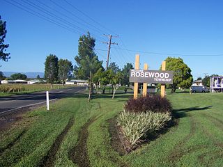
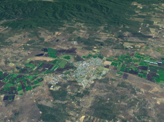
Rosewood is a rural town and locality in the City of Ipswich, Queensland, Australia. In the 2016 census, the locality of Rosewood had a population of 2,834 people.

<span class="mw-page-title-main">North Ipswich, Queensland</span> Suburb of Ipswich, Queensland, Australia

North Ipswich is a suburb of Ipswich in the City of Ipswich, Queensland, Australia. In the 2016 census, North Ipswich had a population of 4,515 people.

<span class="mw-page-title-main">Bundamba, Queensland</span> Suburb of Ipswich, Queensland, Australia

Bundamba is a suburb of Ipswich in the City of Ipswich, Queensland, Australia. In the 2016 census Bundamba had a population of 6,514 people.

<span class="mw-page-title-main">Booval, Queensland</span> Suburb of Ipswich, Queensland, Australia

Booval is a suburb of Ipswich in the City of Ipswich, Queensland, Australia. In the 2016 census Booval had a population of 2,622 people.

<span class="mw-page-title-main">Leichhardt, Queensland</span> Suburb of Ipswich, Queensland, Australia

Leichhardt is a suburb of Ipswich in the City of Ipswich, Queensland, Australia. In the 2021 census, Leichhardt had a population of 4,471 people.

<span class="mw-page-title-main">Woodend, Queensland</span> Suburb of Ipswich, Queensland, Australia

Woodend is an inner suburb of Ipswich in the City of Ipswich, Queensland, Australia. In the 2021 census, Woodend had a population of 1,483 people.

<span class="mw-page-title-main">Sadliers Crossing, Queensland</span> Suburb of Ipswich, Queensland, Australia

Sadliers Crossing is a suburb of Ipswich in the City of Ipswich, Queensland, Australia. In the 2016 census, Sadliers Crossing had a population of 1,366 people.

<span class="mw-page-title-main">Karrabin, Queensland</span> Suburb of Ipswich, Queensland, Australia

Karrabin is a rural locality in the City of Ipswich, Queensland, Australia. In the 2016 census, Karrabin had a population of 423 people.

<span class="mw-page-title-main">Haigslea, Queensland</span> Suburb of Ipswich, Queensland, Australia

Haigslea is a locality split between the City of Ipswich and the Somerset Region in South East Queensland, Australia. In the 2016 census, Haigslea had a population of 468 people.

<span class="mw-page-title-main">Ipswich (suburb), Queensland</span> Suburb of Ipswich, Queensland, Australia

Ipswich Central Business District is the central suburb and central business district of Ipswich in the City of Ipswich, Queensland, Australia. It is also known as Ipswich CBD. In the 2016 census, the suburb had a population of 2,459 people.

<span class="mw-page-title-main">Shire of Brassall</span>

The Shire of Brassall is a former local government area in the south-east of Queensland, Australia. It existed from 1879 to 1917.

<span class="mw-page-title-main">Bundaberg North, Queensland</span> Suburb of Bundaberg, Queensland, Australia

Bundaberg North is a suburb of Bundaberg in the Bundaberg Region, Queensland, Australia. In the 2016 census, Bundaberg North had a population of 5,451 people. It occupies the developed area north of the Burnett River, opposite the Bundaberg CBD.

References

  1. Australian Bureau of Statistics (28 June 2022). "Brassall (suburb and locality)". Australian Census 2021 QuickStats. Retrieved 28 June 2022.  OOjs UI icon edit-ltr-progressive.svg
  2. 1 2 "Brassall - Suburb – suburb in City of Ipswich (entry 45031)". Queensland Place Names. Queensland Government . Retrieved 16 May 2020.
  3. 1 2 Australian Bureau of Statistics (28 June 2022). "Brassall". 2021 Census QuickStats. Retrieved 20 April 2024. OOjs UI icon edit-ltr-progressive.svg
  4. "Queensland Globe". State of Queensland . Retrieved 3 January 2017.
  5. Google (7 January 2024). "Brassall, Queensland" (Map). Google Maps . Google. Retrieved 7 January 2024.
  6. "Boody's Store - Hungry Flats - Brassall". Ipswich Libraries. 1944. Retrieved 25 January 2024.
  7. "Opening and closing dates of Queensland Schools". Queensland Government . Retrieved 18 April 2019.
  8. 1 2 3 Queensland Family History Society (2010), Queensland schools past and present (Version 1.01 ed.), Queensland Family History Society, ISBN   978-1-921171-26-0
  9. "Brassall Anglicans". Queensland Times . Vol. LXIV, no. 11, 329. Queensland, Australia. 13 February 1923. p. 5. Archived from the original on 28 August 2021. Retrieved 6 July 2020 via National Library of Australia.
  10. Anglican Church of Southern Queensland. "Closed Churches". Archived from the original on 3 April 2019. Retrieved 3 July 2020.
  11. "NEW LUTHERAN CHURCH AT GATTON". Queensland Times . No. 19, 918. Queensland, Australia. 3 November 1950. p. 5 (DAILY). Archived from the original on 17 February 2021. Retrieved 17 February 2021 via National Library of Australia.
  12. Google (16 February 2021). "St Mark's Lutheran Church (Street View)" (Map). Google Maps . Google. Retrieved 16 February 2021.
  13. Foley, Peter (19 November 2007). "Humble start fondly recalled". Queensland Times. Retrieved 16 February 2021.
  14. "St Mark's Lutheran Church". Churches Australia. Archived from the original on 28 August 2021. Retrieved 16 February 2021.
  15. "Brassall (entry 45031)". Queensland Place Names. Queensland Government . Retrieved 21 June 2017.
  16. "North Ipswich Uniting Church - Former". Churches Australia. Archived from the original on 28 August 2021. Retrieved 28 August 2021.
  17. "Mihi Creek Complex (entry 700010)". Queensland Heritage Register . Queensland Heritage Council. Retrieved 9 July 2013.
  18. "Klondyke Coke Ovens (entry 602566)". Queensland Heritage Register . Queensland Heritage Council. Retrieved 9 July 2013.
  19. 1 2 3 4 5 "State and non-state school details". Queensland Government. 9 July 2018. Archived from the original on 21 November 2018. Retrieved 21 November 2018.
  20. "Brassall State School". Archived from the original on 27 March 2021. Retrieved 21 November 2018.
  21. 1 2 3 "ACARA School Profile 2018". Australian Curriculum, Assessment and Reporting Authority. Archived from the original on 27 August 2020. Retrieved 28 January 2020.
  22. "Brassall SS - Special Education Program". Archived from the original on 27 March 2021. Retrieved 21 November 2018.
  23. "Ipswich State High School". Archived from the original on 9 November 2020. Retrieved 21 November 2018.
  24. "Ipswich SHS - Special Education Program". Archived from the original on 9 November 2020. Retrieved 21 November 2018.
  25. "Ipswich Adventist School". Archived from the original on 26 February 2019. Retrieved 21 November 2018.
  26. "Ipswich Libraries: Mobile library schedule of stops - January to June 2018" (PDF). Ipswich City Council . Archived from the original (PDF) on 30 January 2018. Retrieved 30 January 2018.
  27. "Lutheran Church Brassall St Marks Congregation, Qld". Brassall St Marks Congregation, Qld. Archived from the original on 28 August 2021. Retrieved 16 February 2021.
  28. "The Uniting Churches of Ipswich". Archived from the original on 20 March 2021. Retrieved 27 August 2021.
  29. "Find a church". Uniting Church in Australia, Queensland Synod. Archived from the original on 24 October 2020. Retrieved 6 May 2021.
  30. "Ipswich North Uniting Church". Churches Australia. Archived from the original on 28 August 2021. Retrieved 28 August 2021.
  31. "Islamic Society of Ipswich Queensland". Archived from the original on 6 July 2020. Retrieved 6 July 2020.