Gailes, Queensland

Last updated

Map all coordinates using: OpenStreetMap  
Download coordinates as: KML  ·  GPX
Gailes
Ipswich,  Queensland
Australia Queensland location map.svg
Red pog.svg
Gailes
Coordinates 27°36′50″S152°54′37″E / 27.6138°S 152.9102°E / -27.6138; 152.9102 (Gailes (centre of suburb))
Population1,828 (2016 census) [1]
 • Density1,410/km2 (3,640/sq mi)
Postcode(s) 4300
Area1.3 km2 (0.5 sq mi)
Time zone AEST (UTC+10:00)
Location
State electorate(s) Jordan
Federal Division(s) Oxley
Suburbs around Gailes:
Goodna Wacol Wacol
Goodna Gailes Carole Park
Goodna Camira Carole Park

Gailes is a suburb of Ipswich in the City of Ipswich, Queensland, Australia. [2] In the 2016 census Gailes had a population of 1,828 people. [1]

Contents

Geography

The suburb is bounded to the north by the Ipswich Motorway and the Main Line railway and to the west by Woogaroo Creek, a tributary of the Brisbane River. [3] [4]

The land use is predominantly residential with a small amount of undeveloped bushland in the south-west of the locality. [3]

History

House flooded in Gailes, 12 January 2011 House flooded in the Ipswich suburb of Gailes.jpg
House flooded in Gailes, 12 January 2011

In 1823 explorer John Oxley named a local high point Dingo Hill ( 27°36′54″S152°54′59″E / 27.6150°S 152.9164°E / -27.6150; 152.9164 (Dingo Hill) ) which became the local name for the area. [5] This led to a local railway siding to also be named Dingo Hill. [6]

On 16 September 1925, the Dingo Hill railway siding was upgraded and renamedGailes railway station ( 27°36′08″S152°55′08″E / 27.6021°S 152.9189°E / -27.6021; 152.9189 (Gailes railway station) ), after the Western Gailes Golf Club in Ayrshire, Scotland. [7] The suburb of Gailes takes its name from the railway station. The name Gailes means "overgrown by bog-myrth". [2]

Suburban boundary changes in 1986 resulted in the Gailes railway station now being within the suburb of Wacol in City of Brisbane. [3] Similarly the hill Dingo Hill is now within the neighbouring suburb of Camira. [3]

In January 2011 Gailes was flooded during the 2011 Queensland floods. [8]

In the 2011 census Gailes had a population of 1,646 people. [9]

In the 2016 census Gailes had a population of 1,828 people. [1]

Transport

There is no railway station within the suburb of Gailes. The nearest railway stations are Goodna railway station and Gailes railway station, both of which provide regular Queensland Rail City network services to Brisbane, Ipswich and Rosewood via Ipswich. [3]

Education

There are no schools in Gailes. The nearest primary school is Camira State School in neighbouring Camira to the south. The nearest secondary schools are Bellbird Park State Secondary College in Bellbird Park to the south-west and Woodcrest State College in Springfield to the south. [3]

Facilities

Gailes Post Office is at Gailes Shopping Centre, 65 Old Logan Road ( 27°36′40″S152°54′57″E / 27.6111°S 152.9158°E / -27.6111; 152.9158 (Gailes Post Office) ). [10] [11]

Amenities

There are a number of parks in the area, including:

Related Research Articles

Gailes railway station, Brisbane

Gailes railway station is located on the Main line in Queensland, Australia. Despite the name, it is not in the suburb of Gailes, City of Ipswich, but in the neighbouring suburb in Wacol, City of Brisbane. In 1919, the station was named Dingo Hill and renamed in 1925 to Gailes.

Darra, Queensland Suburb of Brisbane, Queensland, Australia

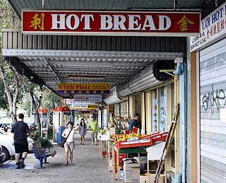
Darra is a suburb in the City of Brisbane, Queensland, Australia. In the 2016 census, Darra had a population of 4,343 people.

Goodna, Queensland Suburb of Ipswich, Queensland, Australia

Goodna is a suburb on the eastern edge of the City of Ipswich in Queensland, Australia. In the 2016 census, Goodna had a population of 10,461 people.

Wacol, Queensland Suburb of Brisbane, Queensland, Australia

Wacol is a suburb in the City of Brisbane, Queensland, Australia. In the 2016 census, Wacol had a population of 3,761 people.

Carole Park, Queensland Suburb of Ipswich, Queensland, Australia

Carole Park is an industrial suburb in the City of Ipswich, Queensland, Australia. In the 2016 census Carole Park had a population of 4 people.

North Ipswich, Queensland Suburb of Ipswich, Queensland, Australia

North Ipswich is a suburb Ipswich in the City of Ipswich, Queensland, Australia. Raymonds Hill is a neighbourhood within the suburb of North Ipswich. In the 2016 census, North Ipswich had a population of 4,515 people.

Bundamba, Queensland Suburb of Ipswich, Queensland, Australia

Bundamba is a large suburb of City of Ipswich, Queensland, Australia. At the 2016 Australian Census the suburb recorded a population of 6,514.

East Ipswich, Queensland Suburb of Ipswich, Queensland, Australia

East Ipswich is a residential inner-city suburb of Ipswich in the City of Ipswich, Queensland, Australia. In the 2016 census, East Ipswich had a population of 2,410 people.

Newtown, Queensland (Ipswich) Suburb of Ipswich, Queensland, Australia

Newtown is a suburb in the City of Ipswich, Queensland, Australia. In the 2016 census, Newtown had a population of 1,615 people.

Booval, Queensland Suburb of Ipswich, Queensland, Australia

Booval is a suburb of Ipswich in the City of Ipswich, Queensland, Australia. In the 2016 census Booval had a population of 2,622 people.

Dinmore, Queensland Suburb of Ipswich, Queensland, Australia

Dinmore is a suburb of the City of Ipswich, Queensland, Australia. In the 2016 census, Dinmore had a population of 875 people. According to the 2016 Australian Census the Dinmore unemployment rate was 16.7%, in comparison to the Australian unemployment rate of 6.9%.

Riverview, Queensland Suburb of Ipswich, Queensland, Australia

Riverview is a suburb of Ipswich in the City of Ipswich, Queensland, Australia. In the 2016 census, Riverview had a population of 3,073 people and an unemployment rate of 15.7%, compared to the Australian unemployment rate of 6.9%.

West Ipswich, Queensland Suburb of Ipswich, Queensland, Australia

West Ipswich is a suburb of Ipswich in the City of Ipswich, Queensland, Australia. At the 2016 census, West Ipswich recorded a population of 494.

Collingwood Park, Queensland Suburb of City of Ipswich, Queensland, Australia

Collingwood Park is a suburb of Ipswich in the City of Ipswich, Queensland, Australia. In the 2016 census, Collingwood Park had a population of 7,104 people.

Barellan Point, Queensland Suburb of Ipswich, Queensland, Australia

Barellan Point is a rural residential suburb in the City of Ipswich, Queensland, Australia. In the 2016 census Barellan Point had a population of 1,159 people.

Camira, Queensland Suburb of City of Ipswich, Queensland, Australia

Camira is a suburb in the City of Ipswich, Queensland, Australia. In the 2016 census Camira had a population of 7,414 people.

Springfield Lakes, Queensland Suburb of City of Ipswich, Queensland, Australia

Springfield Lakes is a suburb in the City of Ipswich, Queensland, Australia. It is one of the suburbs created within Greater Springfield. In the 2016 census, Springfield Lakes had a population of 15,318 people.

Ipswich (suburb), Queensland Suburb of Ipswich, Queensland, Australia

Ipswich is the central suburb of the City of Ipswich, Queensland, Australia. It is also known as Ipswich CBD. In the 2016 census, the suburb had a population of 2,459 people.

Springfield Central, Queensland Suburb of City of Ipswich, Queensland, Australia

Springfield Central is a suburb in the City of Ipswich, Queensland, Australia. In the 2016 census, Springfield Central had a population of 114 people. It is the designated business district of Greater Springfield.

Glenfern, Queensland Suburb of Somerset Region, Queensland, Australia

Glenfern is a rural locality in the Somerset Region, Queensland, Australia. In the 2016 census Glenfern had a population of 10 people.

References

  1. 1 2 3 Australian Bureau of Statistics (27 June 2017). "Gailes (SSC)". 2016 Census QuickStats. Retrieved 20 October 2018. OOjs UI icon edit-ltr-progressive.svg
  2. 1 2 "Gailes – suburb in City of Ipswich (entry 45047)". Queensland Place Names. Queensland Government . Retrieved 27 December 2020.
  3. 1 2 3 4 5 6 "Queensland Globe". State of Queensland . Retrieved 11 February 2021.
  4. "Woogaroo Creek – watercourse in the City of Brisbane (entry 38023)". Queensland Place Names. Queensland Government . Retrieved 11 February 2021.
  5. "Dingo Hill – hill in the City of Ipswich (entry 46290)". Queensland Place Names. Queensland Government . Retrieved 11 February 2021.
  6. "It's official, Dingo Hill exists". Queensland Times. 25 February 2010. Archived from the original on 11 February 2021. Retrieved 11 February 2021.
  7. "Dingo Hill". The Telegraph (16, 475). Queensland, Australia. 19 September 1925. p. 5. Archived from the original on 11 February 2021. Retrieved 11 February 2021 via National Library of Australia.
  8. "Looking back on the devastating Queensland floods of 2011". 7NEWS.com.au. 11 January 2020. Archived from the original on 11 February 2021. Retrieved 11 February 2021.
  9. Australian Bureau of Statistics (31 October 2012). "Gailes (State Suburb)". 2011 Census QuickStats. Retrieved 16 February 2014. OOjs UI icon edit-ltr-progressive.svg
  10. "Building areas - Queensland". Queensland Open Data. Queensland Government. 17 November 2020. Archived from the original on 17 November 2020. Retrieved 17 November 2020.
  11. "Gailes LPO". Australia Post . Archived from the original on 11 February 2021. Retrieved 11 February 2021.
  12. 1 2 3 4 5 "Land for public recreation - Queensland". Queensland Open Data. Queensland Government. 20 November 2020. Archived from the original on 22 November 2020. Retrieved 22 November 2020.