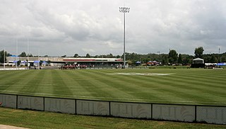
Redbank Ipswich, Queensland | |||||||||||||||
---|---|---|---|---|---|---|---|---|---|---|---|---|---|---|---|
Coordinates | 27°36′11″S152°52′24″E / 27.6030°S 152.8733°E Coordinates: 27°36′11″S152°52′24″E / 27.6030°S 152.8733°E | ||||||||||||||
Population | 1,834 (2016 census) [1] | ||||||||||||||
• Density | 221.0/km2 (572/sq mi) | ||||||||||||||
Postcode(s) | 4301 | ||||||||||||||
Area | 8.3 km2 (3.2 sq mi) | ||||||||||||||
Time zone | AEST (UTC+10:00) | ||||||||||||||
Location |
| ||||||||||||||
LGA(s) | City of Ipswich | ||||||||||||||
State electorate(s) | Bundamba | ||||||||||||||
Federal division(s) | Oxley | ||||||||||||||
|
Redbank is a suburb in the City of Ipswich, Queensland, Australia. [2] In the 2016 census, Redbank had a population of 1,834 people. [1]
The suburb is bounded to the west by Six Mile Creek, to the north-west, north, and north-east by the Brisbane River, to the east by Goodna Creek, and to the south-west by another segment of Goodna Creek. [3]
The Ipswich Motorway enters the locality from the east (Goodna) and exits to the west (Riverview). [3] The Main Line railway runs parallel but north of the motorway with two railway stations in the suburb:
The land use north of the railway line through to the river is a mix of industrial, commercial and agricultural use. The Redbank Railway Workshops being a major industry in the suburb. The land between the railway line and the motorway is predominantly residential. The land south of the motorway is a large tract of undeveloped bushland with further residential development in the far south of the suburb. [3]
The origin of the suburb name is from a description of the area provided by Major Edmund Lockyer whilst exploring in a boat along the Brisbane River. [2]
While the Redbank area is known for its agricultural and pastoral origins, it has a more varied history. [5]
In the late 1850s, the first farmers in the area settled on the river flats situated to the north of the current railway station. This settlement featured a brickworks, sawmill, stores, cottages, a school and nondenominational church, though due to severe flooding, it was relocated south of the railway station some years later. [5]
In the early years, the rich black loamy soil of the plains supported crops of maize, potatoes and fodder, while cotton became a significant crop in the 1860s and 1870s. [5] By the beginning of the 20th century, dairying became more important with the establishment of several creameries in the area. [5]
The late 1850s saw the establishment of the first secondary industry in the area, with a boiling down works and fellmongery owned by Mr John Campbell and Mr Town. [5]
Redbank's school was originally opened on July 1865 by the Roman Catholic Church on a 2-acre (0.81 ha) land parcel with an initial enrolment of 31 students. The building was used as both a school and a church. In 1881, it became Redbank State School. It closed on 30 September 1895, but reopened on 6 September 1897. [6] In 1951, a further 5.5 acres (2.2 ha) of land was acquired to expand the school site. [7]
The Redbank - Bundamba Loop Line comprised a series of railway sidings serving coal mines in the area. [8] [ when? ]
Redbank Rifle Range operated from 1912 to 1980 south of the Redbank railway station. It was the home of a number rifle clubs over the years including Ipswich Railway Rifle Club, Ipswich City Rifle Club, Ipswich and District Rifle Club, which were involved in competitive target shooting. The 700-yard (640 m) firing mound was about 35 metres (38 yd) from the railway station with the targets 700 yards (640 m) away (approx 27°36′21″S152°52′32″E / 27.6057°S 152.8755°E ). [9] During World War II, there was a large military camp and training area at the range with up to 6,000 Australian and American troops. [10] The development of the Ipswich Motorway reduced the length of the rifle range which led to the relocation of the Ipswich and District Rifle Club to South Ripley in 1972. [11] [12]
The Redbank Railway Workshops has been operating in the suburb since 1958.[ citation needed ]
The current Redbank Plaza Library was opened in 1998 and had a major refurbishment in 2010. [13]
In the 2016 census, Redbank had a population of 1,834 people. Redbank had an unemployment rate of 14.5%, more than double the Australian unemployment rate of 6.9%. [1]
Redbank State School is a government primary (Prep-6) school for boys and girls at 9 Brisbane Road ( 27°36′10″S152°51′52″E / 27.6029°S 152.8645°E ). [14] [15] In 2018, the school had an enrolment of 184 students with 16 teachers (13 full-time equivalent) and 19 non-teaching staff (11 full-time equivalent). [16]
There are no secondary schools in Redbank. The nearest government secondary school is Bellbird Park State Secondary College in neighbouring Bellbird Park to the south. [3]
Redbank Plaza is a shopping centre at 1 Collingwood Drive ( 27°36′20″S152°52′04″E / 27.6055°S 152.8679°E ). [17] [18] It has supermarkets, department stores, a cinema complex and many speciality stores. [19]
Ipswich City Council operates a public library in Redbank at Level 3 Redbank Plaza Shopping Centre. [20]
The Redbank-Collingwood Park Sport complex, accessed from Collingwood Drive ( 27°36′18″S152°52′19″E / 27.6050°S 152.8720°E ) has a soccer field, netball, volleyball, tennis and basketball courts. [21] [22]
Redbank Memorial Reserve in Bridge Street ( 27°35′59″S152°52′30″E / 27.5997°S 152.8750°E ) has a number of war memorials, most of which have been relocated from other sites in the area. [23] [24]
There are a number of other parks in the area: [25]
Redbank railway station provides access to regular Queensland Rail City network services to Brisbane CBD, Ipswich and Rosewood. The Redbank train station has a Queensland Police Service Rail Squad stationed on platform 2 near the ticket office.[ citation needed ]
Oxley is a south-western suburb in the City of Brisbane, Queensland, Australia. In the 2016 census, Oxley had a population of 8,336 people.
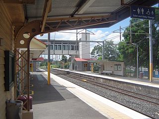
Redbank railway station is located on the Main line in Queensland, Australia. It serves the Ipswich suburb of Redbank.
Springfield is a suburb in the City of Ipswich, Queensland, Australia. In the 2016 census Springfield had a population of 6,772 people.
Wacol is a suburb in the City of Brisbane, Queensland, Australia. In the 2016 census, Wacol had a population of 3,761 people.
Sherwood is a suburb in the City of Brisbane, Queensland, Australia. In the 2016 census, Sherwood had a population of 5,313 people.
Richlands is an outer south-western suburb in the City of Brisbane, Queensland, Australia. In the 2016 census, Richlands had a population of 3,598 people.
Redbank Plains is a suburb in the City of Ipswich, Queensland, Australia. In the 2016 census, Redbank Plains had a population of 19,299 people.
Bundamba is a suburb of Ipswich in the City of Ipswich, Queensland, Australia. In the 2016 census Bundamba had a population of 6,514 people.
Eastern Heights is a suburb of Ipswich in the City of Ipswich, Queensland, Australia. In the 2016 census, Eastern Heights had a population of 3,709 people.
Dinmore is a suburb of Ipswich in the City of Ipswich, Queensland, Australia. In the 2016 census, Dinmore had a population of 875 people with an unemployment rate of 16.7%, in comparison to the Australian unemployment rate of 6.9%.
Riverview is a suburb of Ipswich in the City of Ipswich, Queensland, Australia. In the 2016 census, Riverview had a population of 3,073 people and an unemployment rate of 15.7%, compared to the Australian unemployment rate of 6.9%.
Woodend is an inner suburb of Ipswich in the City of Ipswich, Queensland, Australia. In the 2016 census, Woodend had a population of 1,302 people.
Sadliers Crossing is a suburb of Ipswich in the City of Ipswich, Queensland, Australia. In the 2016 census, Sadliers Crossing had a population of 1,366 people.
West Ipswich is a suburb of Ipswich in the City of Ipswich, Queensland, Australia. In the 2016 census, West Ipswich had a population of 494 people.
Wulkuraka is a western suburb of Ipswich in the City of Ipswich, Queensland, Australia. In the 2016 census, Wulkuraka had a population of 1,234 people.
Collingwood Park is a suburb of Ipswich in the City of Ipswich, Queensland, Australia. In the 2016 census, Collingwood Park had a population of 7,104 people.
Bellbird Park is a suburb in the City of Ipswich, Queensland, Australia. In the 2016 census Bellbird Park had a population of 6,736 people.
Gailes is a suburb of Ipswich in the City of Ipswich, Queensland, Australia. In the 2016 census Gailes had a population of 1,828 people.
Augustine Heights is a suburb in the City of Ipswich, Queensland, Australia. In the 2016 census, Augustine Heights had a population of 4,880 people.
Brookwater is a suburb in the City of Ipswich, Queensland, Australia. It is one of the suburbs of the Greater Springfield Development. In the 2016 census Brookwater had a population of 2,151 people.