Collingwood Park, Queensland

Last updated

Collingwood Park
City of Ipswich,  Queensland
Collingwood Park Shopping Centre 2023.jpg
Collingwood Park Shopping Centre, 2023
Australia Queensland location map.svg
Red pog.svg
Collingwood Park
Coordinates 27°37′23″S152°51′22″E / 27.6230°S 152.8561°E / -27.6230; 152.8561
Population7,104 (2016 census) [1]
 • Density960/km2 (2,486/sq mi)
Established1982
Postcode(s) 4301
Area7.4 km2 (2.9 sq mi)
Time zone AEST (UTC+10:00)
Location
LGA(s) City of Ipswich
State electorate(s) Bundamba
Federal division(s)
Suburbs around Collingwood Park:
New Chum Riverview Redbank
New Chum Collingwood Park Redbank
Redbank Plains Redbank Plains Redbank Plains

Collingwood Park is a suburb of Ipswich in the City of Ipswich, Queensland, Australia. [2] In the 2016 census, Collingwood Park had a population of 7,104 people. [1]

Contents

Geography

Collingwood Park, a residential suburb, is 11 kilometres (6.8 mi) east of the Ipswich, next to the historic suburb of Redbank. Its eastern boundary is delineated by Goodna Creek and the western boundary by Six Mile Creek. Housing development began circa 1980 with the establishment of two HIA display villages. Redbank Plaza is a large shopping mall, located on the northern boundary of the suburb. [3] The main thoroughfare is Collingwood Drive which runs south from the shopping centre.

History

The suburb was named and bounded on 28 August 1982. [2]

Throughout the 1980s, Collingwood Park was marketed as, "The Dress Circle Suburb of Ipswich". The suburb's name implied a "leafy" residential area which differentiated it from nearby Redbank, the site of several collieries and industries: a map, c1940, showed the area as devoid of any development apart from a perimeter road.

Notable events which drew attention to the area included 13th Australian Scout Jamboree, 1982–83, the annual 5 kilometres (3.1 mi) Collingwood Park fun run and the 1983 radio 4BK house giveaway and concert held on the site of the current state school.

Collingwood Park State School opened on 28 January 1986. [4]


Smithy’s Childcare Centre was built and opened in January 1994. In 2001 ABC Early Learning took ownership of the service. In 2009 Goodstart Early Learning took ownership of the service.


WoodLinks State School opened on 1 January 2011. [5] [6]

At the 2011 census Collingwood Park recorded a population of 6,622 people. [7]

In the 2016 census, Collingwood Park had a population of 7,104 people. [1]

Education

Woodlinks State School, 2016 Main entrance to Woodlinks State School at Collingwood Park, Queensland.jpg
Woodlinks State School, 2016

Collingwood Park State School is a government primary (Prep-6) school for boys and girls on the corner of Burrel and Hannant Streets ( 27°36′52″S152°51′47″E / 27.6144°S 152.8630°E / -27.6144; 152.8630 (Collingwood Park State School) ). [8] [9] In 2017, the school had an enrolment of 558 students with 45 teachers (37 full-time equivalent) and 23 non-teaching staff (16 full-time equivalent). [10] It includes a special education program. [8]

WoodLinks State School is a government primary (Prep-6) school for boys and girls at WoodLinks Way ( 27°37′49″S152°51′10″E / 27.6302°S 152.8527°E / -27.6302; 152.8527 (WoodLinks State School) ). [8] [11] In 2017, the school had an enrolment of 608 students with 41 teachers (38 full-time equivalent) and 28 non-teaching staff (18 full-time equivalent). [10] It includes a special education program. [8]

There are no secondary schools in Collingwood Park. The nearest secondary schools are in Redbank Plains and Bellbird Park. [12]

Flora and fauna

Collingwood Park and its surrounds are within the catchment area identified as the Six Mile, Woogaroo and Goodna Creek (SWAG). Over 1300 species of plants, including grass trees and hoop pines, and animals including reptiles, mammals, birds, fish and insects have been recorded in the SWAG Catchment area, with approximately 90% being native species. Exotic, or introduced, species include: blue billygoat weed, groundsel, Chinese elm, salvinia, lantana, camphor laurel, cane toad, spotted turtle dove, common myna, fox and hare.

Some of the rare, endangered and vulnerable species recorded around Collingwood Park include: the Powerful owl (Ninox strenua), Black-chinned honeyeater (Melithreptus gularis), Glossy black cockatoo (Calyptorhynchus lathami) and the Grey goshawk (Accipiter novaehollandiae).

Transport

Collingwood Park has on and off ramps to the M7 Ipswich Motorway going both east to Brisbane and west to Ipswich. The suburb has several regular Translink bus services. Less than 1 kilometre (0.62 mi) away is Redbank railway station which is on the Ipswich train line.

Governance

Ipswich City Council operates a public library at Redbank Plaza. Collingwood Park is in the Ipswich City Council Division 3. Lance McCallum is the State Member for Bundamba, Collingwood Park is in the Federal seats of Oxley represented by Milton Dick and Blair represented by Shane Neumann.

Parks and recreation

Dodrill Park on Whitlam Drive, is named after a highly regarded local resident, Mitch Dodrill, who has lived in Collingwood Park since 1979, and has represented Collingwood Park residents in many local matters. His son Jim Dodrill continues to represent the residents of Collingwood Park in matters of importance.

Goupong Park on Namatjira Drive, Robert Anderson was a Ugarapul tribal man and was known by his tribal name "Goupong", meaning frog in the Ugarapul language. This was the language of the traditional people and custodians of the land known today as Ipswich. Robert Anderson was raised at the old Deebing Creek Mission Station and worked on many properties throughout Queensland as a young man. His athletic ability was recognised when he defeated world – record holder Arthur Postle of Pittsworth in a sprint on the Charters Towers goldfields in 1904. Many of his descendants still remain in the traditional country of this great Ugarapul man today.

The Strike Monument commemorates The first strike in Queensland which took place at the Redbank Mine owned by Campbell and Towns. On 7 June 1861, a deputation of miners confronted Robert Campbell with demands including a pay rise of one shilling a ton. Campbell rejected the claims, the miners went on strike and were later arrested and tried for illegally conspiring to injure Campbell's interests. The jury found them not guilty. The park also has a skate/BMX bowl and other facilities, and is a popular recreational location for the young people of the suburb.

Banjo Patterson Park on Laurie Drive, has barbecues, a cricket pitch for social matches, a half court basketball court, and a leash-free dog running area. Both Goupong and Banjo Patterson Park are popular venues for children's parties and other social gatherings. Bailey Street Reserve is a large, temporarily named council reserve which runs from Bailey street to Six Mile Creek. It covers an area which once contained an open cut coal mine. Where it meets the creek, there is a significant freshwater lagoon which is an important habitat for several species of water fowl and a number of other species have been classified as rare, endangered or vulnerable under the Queensland Nature Conservation Act 1992 and Nature Conservation (Wildlife) Regulation 1994.

Related Research Articles

<span class="mw-page-title-main">Oxley, Queensland</span> Suburb of Brisbane, Queensland, Australia

Oxley is a south-western suburb in the City of Brisbane, Queensland, Australia. In the 2016 census, Oxley had a population of 8,336 people.

<span class="mw-page-title-main">Redbank railway station</span> Railway station in Queensland, Australia

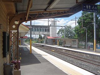
Redbank railway station is located on the Main line in Queensland, Australia. It serves the Ipswich suburb of Redbank.

<span class="mw-page-title-main">Springfield, Queensland</span> Suburb of City of Ipswich, Queensland, Australia

Springfield is a suburb in the City of Ipswich, Queensland, Australia. In the 2021 census, Springfield had a population of 7,322 people.

<span class="mw-page-title-main">Goodna, Queensland</span> Suburb of Ipswich, Queensland, Australia

Goodna is a suburb on the eastern edge of the City of Ipswich in Queensland, Australia. In the 2016 census, Goodna had a population of 10,461 people.

<span class="mw-page-title-main">Pallara, Queensland</span> Suburb of Brisbane, Queensland, Australia

Pallara is an outer southern suburb in the City of Brisbane, Queensland, Australia. In the 2021 census, Pallara had a population of 3,861 people.

<span class="mw-page-title-main">Redbank Plains, Queensland</span> Suburb of Ipswich, Queensland, Australia

Redbank Plains is a suburb in the City of Ipswich, Queensland, Australia. In the 2016 census, Redbank Plains had a population of 19,299 people.

<span class="mw-page-title-main">North Ipswich, Queensland</span> Suburb of Ipswich, Queensland, Australia

North Ipswich is a suburb of Ipswich in the City of Ipswich, Queensland, Australia. In the 2016 census, North Ipswich had a population of 4,515 people.

<span class="mw-page-title-main">Bundamba, Queensland</span> Suburb of Ipswich, Queensland, Australia

Bundamba is a suburb of Ipswich in the City of Ipswich, Queensland, Australia. In the 2016 census Bundamba had a population of 6,514 people.

<span class="mw-page-title-main">Riverview, Queensland</span> Suburb of Ipswich, Queensland, Australia

Riverview is a suburb of Ipswich in the City of Ipswich, Queensland, Australia. In the 2016 census, Riverview had a population of 3,073 people and an unemployment rate of 15.7%, compared to the Australian unemployment rate of 6.9%.

<span class="mw-page-title-main">West Ipswich, Queensland</span> Suburb of Ipswich, Queensland, Australia

West Ipswich is a suburb of Ipswich in the City of Ipswich, Queensland, Australia. In the 2016 census, West Ipswich had a population of 494 people.

<span class="mw-page-title-main">Redbank, Queensland</span> Suburb of Ipswich, Queensland, Australia

Redbank is a suburb in the City of Ipswich, Queensland, Australia. In the 2016 census, Redbank had a population of 1,834 people.

<span class="mw-page-title-main">Karalee, Queensland</span> Suburb of Ipswich, Queensland, Australia

Karalee is a rural residential suburb of Ipswich in the City of Ipswich, Queensland, Australia. In the 2016 census, Karalee had a population of 4352 people.

<span class="mw-page-title-main">Bellbird Park, Queensland</span> Suburb of Ipswich, Queensland, Australia

Bellbird Park is a suburb in the City of Ipswich, Queensland, Australia. In the 2016 census Bellbird Park had a population of 6,736 people.

<span class="mw-page-title-main">Gailes, Queensland</span> Suburb of Ipswich, Queensland, Australia

Gailes is a suburb of Ipswich in the City of Ipswich, Queensland, Australia. In the 2016 census Gailes had a population of 1,828 people.

<span class="mw-page-title-main">Springfield Lakes, Queensland</span> Suburb of Ipswich, Queensland, Australia

Springfield Lakes is a suburb in the City of Ipswich, Queensland, Australia. It is one of the suburbs created within Greater Springfield. In the 2021 census, Springfield Lakes had a population of 17,211 people.

<span class="mw-page-title-main">Augustine Heights, Queensland</span> Suburb of Ipswich, Queensland, Australia

Augustine Heights is a suburb in the City of Ipswich, Queensland, Australia. In the 2016 census, Augustine Heights had a population of 4,880 people.

<span class="mw-page-title-main">Brookwater, Queensland</span> Suburb of Ipswich, Queensland, Australia

Brookwater is a suburb in the City of Ipswich, Queensland, Australia. It is one of the suburbs of the Greater Springfield Development. In the 2016 census Brookwater had a population of 2,151 people.

<span class="mw-page-title-main">Ripley, Queensland</span> Suburb of Ipswich, Queensland, Australia

Ripley is a suburb in the City of Ipswich, Queensland, Australia. In the 2016 census, Ripley had a population of 1,405 people.

<span class="mw-page-title-main">Ipswich (suburb), Queensland</span> Suburb of Ipswich, Queensland, Australia

Ipswich is the central suburb and central business district of Ipswich in the City of Ipswich, Queensland, Australia. It is also known as Ipswich CBD. In the 2016 census, the suburb had a population of 2,459 people.

<span class="mw-page-title-main">Deebing Heights, Queensland</span> Suburb of Ipswich, Queensland, Australia

Deebing Heights is a residential and semi-rural southern suburb of Ipswich in the City of Ipswich, Queensland, Australia. In the 2016 census, Deebing Heights had a population of 2,039 people.

References

  1. 1 2 3 Australian Bureau of Statistics (27 June 2017). "Collingwood Park (SSC)". 2016 Census QuickStats. Retrieved 20 October 2018. OOjs UI icon edit-ltr-progressive.svg
  2. 1 2 "Collingwood Park – suburb in City of Ipswich (entry 47112)". Queensland Place Names. Queensland Government . Retrieved 26 January 2020.
  3. "Jennings announces $50m Queensland joint venture". The Age. 22 February 1984. p. 28. Retrieved 11 September 2022.
  4. Queensland Family History Society (2010), Queensland schools past and present (Version 1.01 ed.), Queensland Family History Society, ISBN   978-1-921171-26-0
  5. "Opening and closing dates of Queensland Schools". Queensland Government . Retrieved 5 March 2020.
  6. "Our school". WoodLinks State School. 22 January 2015. Archived from the original on 14 March 2019. Retrieved 5 March 2020.
  7. Australian Bureau of Statistics (31 October 2012). "Collingwood Park (State Suburb)". 2011 Census QuickStats. Retrieved 25 September 2014. OOjs UI icon edit-ltr-progressive.svg
  8. 1 2 3 4 "State and non-state school details". Queensland Government. 9 July 2018. Archived from the original on 21 November 2018. Retrieved 21 November 2018.
  9. "Collingwood Park State School". Archived from the original on 20 March 2012. Retrieved 21 November 2018.
  10. 1 2 "ACARA School Profile 2017". Archived from the original on 22 November 2018. Retrieved 22 November 2018.
  11. "WoodLinks State School". Archived from the original on 4 March 2015. Retrieved 21 November 2018.
  12. "Queensland Globe". State of Queensland . Retrieved 5 March 2020.