Mount Marrow, Queensland

Last updated

Mount Marrow
Queensland
Mount Marrow State School 2023.jpg
Mount Marrow State School, 2023
Australia Queensland location map.svg
Red pog.svg
Mount Marrow
Coordinates 27°35′52″S152°37′15″E / 27.5977°S 152.6208°E / -27.5977; 152.6208 (Mount Marrow (centre of locality))
Population182 (SAL 2021) [1]
Postcode(s) 4306
Area8.3 km2 (3.2 sq mi)
Time zone AEST (UTC+10:00)
Location
LGA(s) City of Ipswich
State electorate(s) Ipswich West
Federal division(s) Blair
Suburbs around Mount Marrow:
Marburg Haigslea Haigslea
Tallegalla Mount Marrow Walloon
Rosewood Thagoona Thagoona

Mount Marrow is a rural locality in the City of Ipswich, Queensland, Australia. [2] In the 2021 census, Mount Marrow had a population of 182 people. [3]

Contents

Geography

The locality is 18.5 kilometres (11.5 mi) west of the Ipswich CBD. [4]

The locality takes its name from the mountain Mount Marrow which is in the north of the locality ( 27°35′37″S152°37′10″E / 27.5935°S 152.6195°E / -27.5935; 152.6195 (Mount Marrow) ) rising to 270 metres (890 ft) above sea level. [5] [6]

There is a quarry at the mountain extracting aggregate for use in roadworks and other construction projects. [7] Apart from the quarry, the predominant land use is grazing on native vegetation. [8]

History

Mount Marrow State School opened on 4 November 1909. [9]

Demographics

In the 2016 census, Mount Marrow had a population of 195 people. [10]

In the 2021 census, Mount Marrow had a population of 182 people. [3]

Education

Mount Marrow State School is a government primary (Prep-6) school for boys and girls at 272 Thagoona-Haigslea Road ( 27°36′13″S152°37′17″E / 27.6036°S 152.6214°E / -27.6036; 152.6214 (Mount Marrow State School) ). [11] [12] In 2017, the school had an enrolment of 66 students with 5 teachers (4 full-time equivalent) and 6 non-teaching staff (3 full-time equivalent). [13] In 2018, the school had an enrolment of 65 students with 5 teachers (4 full-time equivalent) and 6 non-teaching staff (3 full-time equivalent). [14]

There are no secondary schools in Mount Marrow. The nearest government secondary school is Rosewood State High School in neighbouring Rosewood to the south-west. [15]

Related Research Articles

<span class="mw-page-title-main">Rosewood, Queensland</span> Town in Queensland, Australia

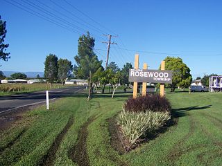
Rosewood is a rural town and locality in the City of Ipswich, Queensland, Australia. In the 2016 census, the locality of Rosewood had a population of 2,834 people.

<span class="mw-page-title-main">Grandchester, Queensland</span> Town in Queensland, Australia

Grandchester is a rural town and locality in the City of Ipswich, Queensland, Australia. In the 2016 census, the locality of Grandchester had a population of 444 people.

<span class="mw-page-title-main">Tivoli, Queensland</span> Suburb of Ipswich, Queensland, Australia

Tivoli is a suburb in the City of Ipswich, Queensland, Australia. In the 2016 census, Tivoli had a population of 1,487 people.

<span class="mw-page-title-main">East Ipswich, Queensland</span> Suburb of Ipswich, Queensland, Australia

East Ipswich is a residential inner-city suburb of Ipswich in the City of Ipswich, Queensland, Australia. In the 2016 census, East Ipswich had a population of 2,410 people.

<span class="mw-page-title-main">Riverview, Queensland</span> Suburb of Ipswich, Queensland, Australia

Riverview is a suburb of Ipswich in the City of Ipswich, Queensland, Australia. In the 2016 census, Riverview had a population of 3,073 people and an unemployment rate of 15.7%, compared to the Australian unemployment rate of 6.9%.

<span class="mw-page-title-main">West Ipswich, Queensland</span> Suburb of Ipswich, Queensland, Australia

West Ipswich is a suburb of Ipswich in the City of Ipswich, Queensland, Australia. In the 2016 census, West Ipswich had a population of 494 people.

<span class="mw-page-title-main">Karrabin, Queensland</span> Suburb of Ipswich, Queensland, Australia

Karrabin is a rural locality in the City of Ipswich, Queensland, Australia. In the 2016 census, Karrabin had a population of 423 people.

<span class="mw-page-title-main">Thagoona, Queensland</span> Suburb of Ipswich, Queensland, Australia

Thagoona is a mixed-use locality in the City of Ipswich, Queensland, Australia. In the 2016 census, Thagoona had a population of 1,025 people.

<span class="mw-page-title-main">Walloon, Queensland</span> Suburb of Ipswich, Queensland, Australia

Walloon is a town and rural residential locality in the City of Ipswich, Queensland, Australia. In the 2016 census the locality of Walloon had a population of 1,588 people.

<span class="mw-page-title-main">Haigslea, Queensland</span> Suburb of Ipswich, Queensland, Australia

Haigslea is a locality split between the City of Ipswich and the Somerset Region in South East Queensland, Australia. In the 2016 census, Haigslea had a population of 468 people.

<span class="mw-page-title-main">Ebenezer, Queensland</span> Suburb of Ipswich, Queensland, Australia

Ebenezer is a rural locality in the City of Ipswich, Queensland, Australia. In the 2016 census, Ebenezer had a population of 315 people.

Jeebropilly is a rural locality in the City of Ipswich, Queensland, Australia. In the 2016 census, Jeebropilly had a population of 7 people.

<span class="mw-page-title-main">Ashwell, Queensland</span> Suburb of Ipswich, Queensland, Australia

Ashwell is a rural locality in the City of Ipswich, Queensland, Australia. In the 2016 census, Ashwell had a population of 85 people.

<span class="mw-page-title-main">Warrill View, Queensland</span> Town in Queensland, Australia

Warrill View is a rural town and locality in the Scenic Rim Region, Queensland, Australia. In the 2021 census, the locality of Warrill View had a population of 203 people.

<span class="mw-page-title-main">Mount Forbes, Queensland</span> Suburb of City of Ipswich, Queensland, Australia

Mount Forbes is a rural locality split between the City of Ipswich and the Scenic Rim Region, Queensland, Australia. In the 2016 census, Mount Forbes had a population of 263 people.

<span class="mw-page-title-main">Mutdapilly, Queensland</span> Suburb of City of Ipswich, Queensland, Australia

Mutdapilly is a rural locality in south-east Queensland, Australia. It is split between the local government areas of Scenic Rim Region and City of Ipswich. In the 2016 census, Mutdapilly had a population of 308 people.

<span class="mw-page-title-main">Mount Whitestone, Queensland</span> Suburb of Lockyer Valley Region, Queensland, Australia

Mount Whitestone is a rural locality in the Lockyer Valley Region, Queensland, Australia. In the 2016 census, Mount Whitestone had a population of 154 people.

<span class="mw-page-title-main">Lower Mount Walker, Queensland</span> Suburb of City of Ipswich, Queensland, Australia

Lower Mount Walker is a locality split between the Scenic Rim Region and City of Ipswich local government areas of South East Queensland, Australia. In the 2021 census, Lower Mount Walker had a population of 192 people.

<span class="mw-page-title-main">Lanefield, Queensland</span> Suburb of Ipswich, Queensland, Australia

Lanefield is a rural locality in the City of Ipswich, Queensland, Australia. In the 2016 census, Lanefield had a population of 107 people.

<span class="mw-page-title-main">Mount Mort, Queensland</span> Suburb of Ipswich, Queensland, Australia

Mount Mort is a rural locality in the City of Ipswich, Queensland, Australia. In the 2021 census, Mount Mort had a population of 78 people.

References

  1. Australian Bureau of Statistics (28 June 2022). "Mount Marrow (suburb and locality)". Australian Census 2021 QuickStats. Retrieved 28 June 2022.  OOjs UI icon edit-ltr-progressive.svg
  2. "Mount Marrow – locality in City of Ipswich (entry 45059)". Queensland Place Names. Queensland Government . Retrieved 29 November 2019.
  3. 1 2 Australian Bureau of Statistics (28 June 2022). "Mount Marrow (SAL)". 2021 Census QuickStats. Retrieved 28 February 2023. OOjs UI icon edit-ltr-progressive.svg
  4. Google (10 December 2023). "Mount Marrow to Ipswich CBD" (Map). Google Maps . Google. Retrieved 10 December 2023.
  5. "Mountain peaks and capes - Queensland". Queensland Open Data. Queensland Government. 12 November 2020. Archived from the original on 25 November 2020. Retrieved 25 November 2020.
  6. "Mount Marrow – mountain in Ipswich City (entry 21085)". Queensland Place Names. Queensland Government . Retrieved 25 November 2020.
  7. "Mt. Marrow Blue Metal Quarries Pty. Ltd. in Mount Marrow | iseekplant". www.iseekplant.com.au. Retrieved 9 December 2023.
  8. "Queensland Globe". State of Queensland . Retrieved 9 December 2023.
  9. Queensland Family History Society (2010), Queensland schools past and present (Version 1.01 ed.), Queensland Family History Society, ISBN   978-1-921171-26-0
  10. Australian Bureau of Statistics (27 June 2017). "Mount Marrow (SSC)". 2016 Census QuickStats. Retrieved 20 October 2018. OOjs UI icon edit-ltr-progressive.svg
  11. "State and non-state school details". Queensland Government. 9 July 2018. Archived from the original on 21 November 2018. Retrieved 21 November 2018.
  12. "Mount Marrow State School". Mount Marrow State School. 29 November 2020. Archived from the original on 31 October 2023. Retrieved 9 December 2023.
  13. "ACARA School Profile 2017". Archived from the original on 22 November 2018. Retrieved 22 November 2018.
  14. "ACARA School Profile 2018". Australian Curriculum, Assessment and Reporting Authority. Archived from the original on 27 August 2020. Retrieved 28 January 2020.
  15. "Layers: Locality; Schools and school catchments". Queensland Globe. Queensland Government. Archived from the original on 19 December 2017. Retrieved 9 December 2023.

Further reading