Eastern Heights, Queensland

Last updated

Eastern Heights
Ipswich,  Queensland
Jim Donald Park Eastern Heights 2023.jpg
Jim Donald Park, 2023
Australia Queensland location map.svg
Red pog.svg
Eastern Heights
Coordinates 27°37′34″S152°46′28″E / 27.6261°S 152.7744°E / -27.6261; 152.7744 (Eastern Heights (centre of suburb))
Population3,709 (2016 census) [1]
 • Density2,180/km2 (5,650/sq mi)
Postcode(s) 4305
Area1.7 km2 (0.7 sq mi)
Time zone AEST (UTC+10:00)
Location
LGA(s) City of Ipswich
State electorate(s) Ipswich
Federal division(s) Blair
Suburbs around Eastern Heights:
Ipswich Newtown Silkstone
Ipswich Eastern Heights Silkstone
Ipswich Raceview Raceview
Eastern Heights, Queensland

Eastern Heights is a suburb of Ipswich in the City of Ipswich, Queensland, Australia. [2] In the 2016 census, Eastern Heights had a population of 3,709 people. [1]

Contents

Geography

Eastern Heights is bordered to the west by Queens Park and Limestone Park.

History

The origin of the suburb name is from a high ridge on the eastern side of the Ipswich CBD. [3]

To serve the growing settlement, the Newtown State School opened in 1882. In 1915 the old school buildings were put up for sale. One section found its way to Redbank Plains State School while the other became the property of W. Pysden a boot repairer in East Street, Ipswich. Many buildings in the Ipswich area have a similar history of migration. [4]

The Catholic Church of our Lady of the Miraculous Medal was opened in 1962 by Coadjutor Bishop Patrick O'Donnell in the presence of the ailing Archbishop James Duhig. [5]

St Peter's Anglican Church was dedicated on 25 September 1977 by Archbishop Felix Arnott. Its closure circa 2 May 2009 was approved by Archbishop Phillip Aspinall. [6] It was at 28 Lloyd George Street ( 27°37′43″S152°46′26″E / 27.6286°S 152.7738°E / -27.6286; 152.7738 (St Peter's Anglican Church (former)) ). [7]

In the 2016 census, Eastern Heights had a population of 3,709 people. [1]

Heritage listings

Fairy Knoll residence, 2015 Fairy Knoll, Eastern Heights, Queensland.jpg
Fairy Knoll residence, 2015

Eastern Heights has a number of heritage-listed sites, including:

Transport

Eastern Heights is serviced by a regular bus service.

Education

There are no schools in Eastern Heights. The nearest government primary schools are Ipswich Central State School in neighbouring Ipswich CBD to the north-west, Silkstone State School in neighbouring Silkstone to the north-east, and Raceview State School in neighbouring Raceview to the south. The nearest government secondary school is Bremer State High School in neighbouring Ipswich CBD to the south-west. [10]

Amenities

Our Lady of the Miraculous Medal Catholic Church (OLMM) is at 33A Robertson Road ( 27°37′41″S152°46′28″E / 27.6281°S 152.7744°E / -27.6281; 152.7744 (Our Lady of the Miraculous Medal Catholic Church) ). [11]

Related Research Articles

<span class="mw-page-title-main">Mitchelton, Queensland</span> Suburb of Brisbane, Queensland, Australia

Mitchelton is a north-western suburb in the City of Brisbane, Queensland, Australia. In the 2016 census, Mitchelton had a population of 8,559 people.

<span class="mw-page-title-main">Darra, Queensland</span> Suburb of Brisbane, Queensland, Australia

Darra is a south-western suburb in the City of Brisbane, Queensland, Australia. In the 2016 census, Darra had a population of 4,343 people.

<span class="mw-page-title-main">Hendra, Queensland</span> Suburb of Brisbane, Queensland, Australia

Hendra is a suburb of the City of Brisbane, Queensland, Australia. In the 2021 census, Hendra had a population of 4,914 people.

<span class="mw-page-title-main">Auchenflower, Queensland</span> Suburb of Brisbane, Queensland, Australia

Auchenflower is an inner suburb of the City of Brisbane, Queensland, Australia. As of the 2021 census, Auchenflower had a total population of 5,670.

<span class="mw-page-title-main">Sherwood, Queensland</span> Suburb of Brisbane, Queensland, Australia

Sherwood is a suburb in the City of Brisbane, Queensland, Australia. In the 2021 census, Sherwood had a population of 6,082 people.

<span class="mw-page-title-main">Rosewood, Queensland</span> Town in Queensland, Australia

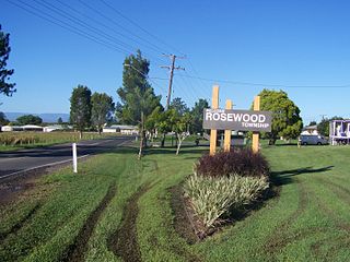
Rosewood is a rural town and locality in the City of Ipswich, Queensland, Australia. In the 2016 census, the locality of Rosewood had a population of 2,834 people.

<span class="mw-page-title-main">North Ipswich, Queensland</span> Suburb of Ipswich, Queensland, Australia

North Ipswich is a suburb of Ipswich in the City of Ipswich, Queensland, Australia. In the 2016 census, North Ipswich had a population of 4,515 people.

<span class="mw-page-title-main">Basin Pocket, Queensland</span> Suburb of Ipswich, Queensland, Australia

Basin Pocket is a suburb of Ipswich in the City of Ipswich, Queensland, Australia. In the 2016 census, Basin Pocket had a population of 890 people.

<span class="mw-page-title-main">Newtown, Queensland (Ipswich)</span> Suburb of Ipswich, Queensland, Australia

Newtown is a suburb in the City of Ipswich, Queensland, Australia. In the 2016 census, Newtown had a population of 1,615 people.

<span class="mw-page-title-main">Raceview, Queensland</span> Suburb of Ipswich, Queensland, Australia

Raceview is a suburb of Ipswich in the City of Ipswich, Queensland, Australia. In the 2016 census, Raceview had a population of 9,721 people.

<span class="mw-page-title-main">Booval, Queensland</span> Suburb of Ipswich, Queensland, Australia

Booval is a suburb of Ipswich in the City of Ipswich, Queensland, Australia. In the 2016 census Booval had a population of 2,622 people.

<span class="mw-page-title-main">Silkstone, Queensland</span> Suburb of Ipswich, Queensland, Australia

Silkstone is a suburb in the City of Ipswich, Queensland, Australia. In the 2016 census, Silkstone had a population of 3,480 people.

<span class="mw-page-title-main">Blackstone, Queensland</span> Suburb of Ipswich, Queensland, Australia

Blackstone is a suburb of Ipswich in the City of Ipswich, Queensland, Australia. In the 2016 census, Blackstone had a population of 1,024 people.

<span class="mw-page-title-main">Flinders View, Queensland</span> Suburb of Ipswich, Queensland, Australia

Flinders View is a suburb of Ipswich in the City of Ipswich, Queensland, Australia. In the 2016 census Flinders View had a population of 5,808 people.

<span class="mw-page-title-main">Riverview, Queensland</span> Suburb of Ipswich, Queensland, Australia

Riverview is a suburb of Ipswich in the City of Ipswich, Queensland, Australia. In the 2016 census, Riverview had a population of 3,073 people and an unemployment rate of 15.7%, compared to the Australian unemployment rate of 6.9%.

<span class="mw-page-title-main">Woodend, Queensland</span> Suburb of Ipswich, Queensland, Australia

Woodend is an inner suburb of Ipswich in the City of Ipswich, Queensland, Australia. In the 2021 census, Woodend had a population of 1,483 people.

<span class="mw-page-title-main">Wulkuraka, Queensland</span> Suburb of Ipswich, Queensland, Australia

Wulkuraka is a western suburb of Ipswich in the City of Ipswich, Queensland, Australia. In the 2016 census, Wulkuraka had a population of 1,234 people.

<span class="mw-page-title-main">Springfield Lakes, Queensland</span> Suburb of City of Ipswich, Queensland, Australia

Springfield Lakes is a suburb in the City of Ipswich, Queensland, Australia. It is one of the suburbs created within Greater Springfield. In the 2021 census, Springfield Lakes had a population of 17,211 people.

<span class="mw-page-title-main">Ipswich (suburb), Queensland</span> Suburb of Ipswich, Queensland, Australia

Ipswich Central Business District is the central suburb and central business district of Ipswich in the City of Ipswich, Queensland, Australia. It is also known as Ipswich CBD. In the 2016 census, the suburb had a population of 2,459 people.

<span class="mw-page-title-main">Purga, Queensland</span> Suburb of City of Ipswich, Queensland, Australia

Purga is a rural locality in the City of Ipswich, Queensland, Australia. In the 2021 census, Purga had a population of 561 people.

References

  1. 1 2 3 Australian Bureau of Statistics (27 June 2017). "Eastern Heights (SSC)". 2016 Census QuickStats. Retrieved 20 October 2018. OOjs UI icon edit-ltr-progressive.svg
  2. "Eastern Heights – suburb in City of Ipswich (entry 45043)". Queensland Place Names. Queensland Government . Retrieved 20 July 2021.
  3. "Eastern Heights – suburb (entry 45043)". Queensland Place Names. Queensland Government . Retrieved 21 June 2017.
  4. Council, Ipswich City. "Suburb and Place Names". www.ipswich.qld.gov.au. Archived from the original on 28 August 2018. Retrieved 20 April 2018.
  5. Blake, Thom. "The Church of our Lady of the Miraculous Medal". Queensland religious places database. Archived from the original on 13 December 2021. Retrieved 13 December 2021.
  6. Anglican Church of Southern Queensland. "Closed Churches". Archived from the original on 3 April 2019. Retrieved 3 July 2020.
  7. Universal Business Directories (Aust.) Pty. Ltd (1990). "Churches and Other Places of Worship". UBD street directory. Brisbane. Universal Business Directories (Australia). pp. 15–19. Archived from the original on 24 August 2020. Retrieved 13 December 2021.{{cite book}}: |author1= has generic name (help)
  8. "Fairy Knoll (entry 600600)". Queensland Heritage Register . Queensland Heritage Council. Retrieved 9 July 2013.
  9. "Garowie (entry 600599)". Queensland Heritage Register . Queensland Heritage Council. Retrieved 9 July 2013.
  10. "Queensland Globe". State of Queensland . Retrieved 12 December 2021.
  11. "The Church of Our Lady of the Miraculous Medal". Churches Australia. Archived from the original on 27 February 2021. Retrieved 13 December 2021.