
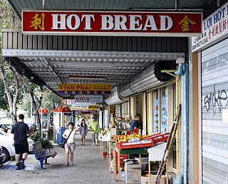
Inala is a south-western suburb in the City of Brisbane, Queensland, Australia. In the 2021 census, Inala had a population of 15,273 people.
Darra is a south-western suburb in the City of Brisbane, Queensland, Australia. In the 2021 census, Darra had a population of 4,098 people.

Forest Lake is an outer south-western suburb of the City of Brisbane, Queensland, Australia. In the 2021 census, Forest Lake had a population of 22,676 people.

Westlake is a south-western suburb in the City of Brisbane, Queensland, Australia. In the 2021 census, Westlake had a population of 4,547 people.

Wacol is a suburb in the City of Brisbane, Queensland, Australia. In the 2021 census, Wacol had a population of 4,253 people.

Larapinta is an outer southern industrial suburb in the City of Brisbane, Queensland, Australia.

Heathwood is an outer south-western suburb in the City of Brisbane, Queensland, Australia. In the 2021 census, Heathwood had a population of 4,944 people.

Archerfield is a mixed-use southern suburb in the City of Brisbane, Queensland, Australia. In the 2021 census, Archerfield had a population of 533 people.

Willawong is an outer southern suburb in the City of Brisbane, Queensland, Australia. In the 2021 census, Willawong had a population of 145 people.
Ellen Grove is an outer south-western suburb in the City of Brisbane, Queensland, Australia. In the 2021 census, Ellen Grove had a population of 3,586 people.

Sumner is a south-western suburb in the City of Brisbane, Queensland, Australia. In the 2021 census, Sumner had a population of 603 people.

Durack is an outer south-western suburb in the City of Brisbane, Queensland, Australia. In the 2021 census, Durack had a population of 7,788 people.

Chuwar is a town and suburb of Ipswich in the City of Ipswich and a locality of the City of Brisbane in South East Queensland, Australia. In the 2021 census, the suburb of Chuwar had a population of 2,178 people.

Doolandella is an outer western suburb in the City of Brisbane, Queensland, Australia. In the 2021 census, Doolandella had a population of 7,123 people.

Pallara is an outer southern suburb in the City of Brisbane, Queensland, Australia. In the 2021 census, Pallara had a population of 3,861 people.

Richlands is an outer south-western suburb in the City of Brisbane, Queensland, Australia. In the 2021 census, Richlands had a population of 5,621 people.
Riverhills is a south-western suburb in the City of Brisbane, Queensland, Australia. It is one of the Centenary suburbs. In the 2021 census, Riverhills had a population of 4,121 people.
The Centenary Suburbs are a group of suburbs in the south-west in the City of Brisbane, Queensland, Australia. The suburbs originated as an "ambitious long-term suburban development proposal that included a number of neighbourhoods, or suburbs, each with sufficient services and facilities for its residents to have their day-to-day needs met without having to go elsewhere".

Camira is a suburb in the City of Ipswich, Queensland, Australia. At the 2021 census, Camira had a population of 7,415 people.

Gailes is a suburb of Ipswich in the City of Ipswich, Queensland, Australia. In the 2021 census, Gailes had a population of 1,831 people.


