Peak Crossing, Queensland

Last updated

Peak Crossing
Queensland
Ipswich Boonah Road at Peak Crossing.jpg
Ipswich Boonah Road, 2015
Australia Queensland location map.svg
Red pog.svg
Peak Crossing
Coordinates 27°47′01″S152°43′49″E / 27.7836°S 152.7303°E / -27.7836; 152.7303 (Peak Crossing (urban area))
Population965 (2016 census) [1]
 • Density10.546/km2 (27.315/sq mi)
Postcode(s) 4306
Area91.5 km2 (35.3 sq mi)
Time zone AEST (UTC+10:00)
Location
LGA(s)
State electorate(s) Scenic Rim
Federal division(s)
Suburbs around Peak Crossing:
Mutdapilly Purga
Goolman
South Ripley
Mutdapilly Peak Crossing Lyons
Harrisville Limestone Ridges
Washpool
Undullah

Peak Crossing is a rural locality split between the City of Ipswich and the Scenic Rim Region of Queensland, Australia. [2] [3] In the 2016 census, Peak Crossing had a population of 965 people. [1]

Contents

Geography

Flinders Peak, 2015 Flinders Peak.jpg
Flinders Peak, 2015

Peak Crossing is located 20 kilometres (12 mi) south of Ipswich. The town is surrounded by farming land, mostly small cropping. [4] The western boundary is marked by the east branch of Warrill Creek, a tributary of the Bremer River. Just upstream from where the road joining Peak Crossing with Mutdapilly crosses Warrill Creek is the Churchbank Weir.

The eastern parts of Peak Crossing are dominated by the naturally vegetated central peaks of the Flinders Peak Group. These include Mount Goolman, Ivorys Rock (Muntambin), Mount Blaine and Flinders Peak. Also located here is the Flinders Peak Conservation Park and sections of the Flinders-Goolman Conservation Estate. These parks are used for bushwalking, horse riding, mountain bike riding and camping. [5]

Ipswich – Boonah Road (State Route 93) runs through from north to south. [6]

History

The name Peak Crossing refers to a mountain and a once important road crossing of Purga Creek.

The mountain Flinders Peak is to the east of the township, named in honour of the explorer Matthew Flinders. [7]

The road crossing is the intersection of the Ipswich-Boonah Road and the Old Warwick Road (which connected Ipswich to the local towns Boonah and Warwick respectively), which is adjacent to Purga Creek. [4] Today, these roads are of less importance as the Cunningham Highway (approx 8 kilometres (5.0 mi) west of Peak Crossing) carries most of the traffic to these destinations.

Purga Creek No 2 School opened on 4 September 1871. [8] It was renamed Peak Mountain State School before 1875. In the late 1920s it was renamed Peak Crossing State School. [9] [10] [11]

The Fassifern railway line (Queensland's first branch railway line) opened from Ipswich to Harrisville on 10 July 1882. Hillside railway station ( 27°44′59″S152°44′12″E / 27.7497°S 152.7367°E / -27.7497; 152.7367 (Hillside railway station) ), Rocktown railway station ( 27°45′50″S152°44′17″E / 27.7639°S 152.7380°E / -27.7639; 152.7380 (Rockton railway station) ) and Peak Crossing railway station ( 27°46′37″S152°44′01″E / 27.7770°S 152.7336°E / -27.7770; 152.7336 (Peak Crossing railway station) ), all on the Ipswich Boonah Road, serve the areas north of Purga Creek. Flinders railway station on Flinders Road ( 27°47′19″S152°43′18″E / 27.7886°S 152.7217°E / -27.7886; 152.7217 (Flinders railway station) ) serves the area south of Purga Creek. On 12 September 1887, the line was extended from Harrisville to Dugundan. The line closed in June 1964. [12] [13]

Peak Crossing Post Office opened on 2 January 1886 (a receiving office had been open from 1885. [14]

Flinders Uniting Church (formerly Congregational), 2005 Flinders Uniting Church (formerly Congregational), Peak Crossing, 2005.jpg
Flinders Uniting Church (formerly Congregational), 2005

In October 1872, tenders were called to construct a Congregational Church near Peak Mountain. [15] In 1929, a new church was built by local builders Walter Florence and Charlie Meier. The former church building was sold and relocated to Rosevale to replace the Lutheran church which was burned down there in 1928. In 1977, the Congregational Church amalgamated into the Uniting Church in Australia. As at 2020, it is known as Flinders Uniting Church. [16]

In 1882, the first Catholic church in the Boonah Parish was erected at Peak Crossing and dedicated to St Patrick. George McDonald donated 1 acre (0.40 ha) of land and the church was built by James Madden of Ipswich. The church was 40 by 25 feet (12.2 by 7.6 m) with 12-foot (3.7 m) high walls and a 15-foot (4.6 m) high roof. It had a Gothic door at the front and each of the two sides of the building had 4 Gothic windows. It was officially opened and blessed on Sunday 10 December 1882 by parish priest of Ipswich, Father Andrew Horan. It had been arranged that Bishop Robert Dunne would officiate but he did not attend on the day. The ceremony attracted a large attendance from local people as well as approximately 400 people who came from Ipswich on a train specially organised for the event. [17] It was not possible to accommodate everyone within the church for the ceremony. [18]

St John's Catholic Church, 2020 St John's Catholic Church, Peak Crossing, 2020 03.jpg
St John's Catholic Church, 2020

In November 1911, St Patrick's Catholic Church was struck by a cyclone and badly damaged. While temporary repairs were carried it, it was discovered that the timber of church had been damaged by white ants. [19] A decision was made to build a new church and St James's Catholic Church was officially opened on 6 September 1914 by Archbishop James Duhig. [20] [21] As at 2020, the church is now known as St John's Catholic Church at 30 Fassifern Street ( 27°47′01″S152°43′51″E / 27.7835°S 152.7307°E / -27.7835; 152.7307 (St John's Catholic Church) ). [21]

On 3 November 1924, a meeting of residents was held at the school to propose the erection of a public hall. [22] In 1925 a piece of land approx 0.75 acres (0.30 ha) was purchased from Wilhelm Althaus for £20. Mr Wyman was the architect for a fee of £6/2/9 and the builder was A. F. Schelbach for £525/5/9. The hall was officially opened on Friday 20 August 1926 by Ernest Bell, the local Member of the Queensland Legislative Assembly for Fassifern. [16]

In the 2011 census, Peak Crossing had a population of 768 people. [23]

In the 2016 census, Peak Crossing had a population of 965 people. [1]

On Remembrance Day, 11 November 2018, the new Peak Crossing ANZAC Memorial was officially dedicated. [24]

Heritage listings

Peak Crossing Public Hall, 2015 Peak Crossing Public Hall.jpg
Peak Crossing Public Hall, 2015

Peak Crossing has the following heritage-listed sites:

Education

Peak Crossing State School, 2020 Entrance to Peak Crossing State School, 2020.jpg
Peak Crossing State School, 2020

Peak Crossing State School is a government primary (Prep-6) school for boys and girls at Ipswich-Boonah Road ( 27°46′47″S152°43′52″E / 27.7798°S 152.7312°E / -27.7798; 152.7312 (Peak Crossing State School) ). [25] [26] In 2018, the school had an enrolment of 215 students with 22 teachers (16 full-time equivalent) and 14 non-teaching staff (8 full-time equivalent). [27]

Amenities

The Peak Mountain View Park on Ipswich Boonah Road ( 27°46′45″S152°43′57″E / 27.7793°S 152.7324°E / -27.7793; 152.7324 (Peak Mountain View Park) ) is provided by the Scenic Rim Regional Council. It features open space with play equipment, electric BBQs, picnic shelters as well as public toilets and off-street car parking. [28] The Peak Crossing ANZAC memorial is within the park. [29] [24]

The Scenic Rim Regional Council operates a mobile library service which visits the Peak Mountain View Park. [30]

The Peak Crossing branch of the Queensland Country Women's Association meets in the Peak Crossing Public Hall. [31]

Related Research Articles

<span class="mw-page-title-main">Boonah, Queensland</span> Town in Queensland, Australia

Boonah is a rural town and locality in the Scenic Rim Region, Queensland, Australia. In the 2016 census, the locality of Boonah had a population of 2,484 people.

<span class="mw-page-title-main">Roadvale, Queensland</span> Town in Queensland, Australia

Roadvale is a rural locality in the Scenic Rim Region, Queensland, Australia. In the 2021 census, Roadvale had a population of 303 people.

<span class="mw-page-title-main">Shire of Boonah</span> Local government area in Queensland, Australia

The Shire of Boonah was a local government area in South East Queensland, Australia, about 80 kilometres (50 mi) southwest of Brisbane. The shire covered an area of 1,921.6 square kilometres (741.9 sq mi), and existed from 1880 until its merger with parts of the Shire of Beaudesert and City of Ipswich to form the Scenic Rim Region on 15 March 2008.

<span class="mw-page-title-main">Scenic Rim Region</span> Local government area in Queensland, Australia

The Scenic Rim Region is a local government area in West Moreton region of South East Queensland, Australia. Established in 2008, it was preceded by several previous local government areas with histories extending back to the early 1900s and beyond. The main town of the region is Beaudesert.

<span class="mw-page-title-main">Dugandan railway line</span> Railway line in Queensland, Australia

The Dugandan railway line was a branch railway in the Scenic Rim region of South East Queensland, Australia. It was also known as the Fassifern railway line. It operated from 1882 to 1964.

<span class="mw-page-title-main">Kalbar, Queensland</span> Town in Queensland, Australia

Kalbar is a rural town and locality in the Scenic Rim Region, Queensland, Australia. In the 2016 census, the locality of Kalbar had a population of 1,093 people.

<span class="mw-page-title-main">Dugandan, Queensland</span> Suburb of Boonah, Queensland, Australia

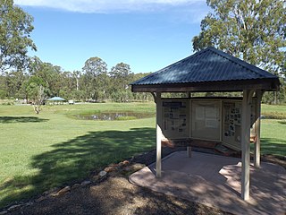
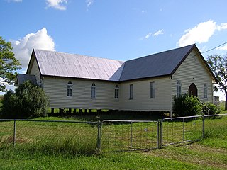
Dugandan is a rural town and locality in the Scenic Rim Region, Queensland, Australia. In the 2016 census, Dugandan had a population of 593 people.

<span class="mw-page-title-main">Purga, Queensland</span> Suburb of City of Ipswich, Queensland, Australia

Purga is a rural locality in the City of Ipswich, Queensland, Australia. In the 2021 census, Purga had a population of 561 people.

<span class="mw-page-title-main">Harrisville, Queensland</span> Town in Queensland, Australia

Harrisville, locally known as the town of churches, is a rural town and locality in the Scenic Rim Region, Queensland, Australia. In the 2016 census, the locality of Harrisville had a population of 613 people.

<span class="mw-page-title-main">Munbilla, Queensland</span> Town in Queensland, Australia

Munbilla is a rural town and locality in the Scenic Rim Region, Queensland, Australia. In the 2016 census, the locality of Munbilla had a population of 100 people.

<span class="mw-page-title-main">Goolman, Queensland</span> Suburb of City of Ipswich, Queensland, Australia

Goolman is a rural locality in the City of Ipswich, Queensland, Australia. In the 2016 census, Goolman had a population of 42 people.

<span class="mw-page-title-main">Templin, Queensland</span> Suburb of Scenic Rim Region, Queensland, Australia

Templin is a rural locality in the Scenic Rim Region, Queensland, Australia. In the 2016 census, Templin had a population of 86 people.

<span class="mw-page-title-main">Coulson, Queensland</span> Suburb of Scenic Rim Region, Queensland, Australia

Coulson is a rural locality in the Scenic Rim Region, Queensland, Australia. In the 2016 census, Coulson had a population of 195 people.

<span class="mw-page-title-main">Blantyre, Queensland</span> Suburb of Scenic Rim Region, Queensland, Australia

Blantyre is a rural locality in the Scenic Rim Region, Queensland, Australia. In the 2016 census, Blantyre had a population of 59 people.

<span class="mw-page-title-main">Fassifern Valley, Queensland</span> Suburb of Scenic Rim Region, Queensland, Australia

Fassifern Valley is a rural locality in the Scenic Rim Region, Queensland, Australia. In the 2016 census, Fassifern Valley had a population of 91 people.

<span class="mw-page-title-main">Milbong, Queensland</span> Suburb of Scenic Rim Region, Queensland, Australia

Milbong is a rural locality in the Scenic Rim Region, Queensland, Australia. In the 2016 census, Milbong had a population of 161 people.

Kulgun is a locality in the Scenic Rim Region, Queensland, Australia. In the 2016 census, Kulgun had a population of 67 people.

Radford is a rural locality in the Scenic Rim Region, Queensland, Australia. In the 2016 census, Radford had a population of 41 people.

Ipswich–Boonah–Rathdowney Road is a continuous 87.8 kilometres (54.6 mi) road route in the Ipswich and Scenic Rim regions of Queensland, Australia. It has two official names, Ipswich–Boonah Road and Boonah–Rathdowney Road. The entire route is signed as State Route 93, and much of it is also part of Tourist Drive 16.

Beaudesert–Boonah–Fassifern Road is a non-continuous 49.9 kilometres (31.0 mi) road route in the Scenic Rim region of Queensland, Australia. It has two official names, Beaudesert–Boonah Road and Boonah–Fassifern Road. The route is signed as State Route 90. These roads are joined by a 6.8 kilometres (4.2 mi) section of Ipswich-Boonah Road. Beaudesert–Boonah Road is a state-controlled regional road, and Boonah–Fassifern Road is also a state-controlled regional road. As part of State Route 90 it provides an alternate route between the Cunningham Highway and the Gold Coast.

References

  1. 1 2 3 Australian Bureau of Statistics (27 June 2017). "Peak Crossing (SSC)". 2016 Census QuickStats. Retrieved 20 October 2018. OOjs UI icon edit-ltr-progressive.svg
  2. "Peak Crossing – locality in City of Ipswich (entry 45068)". Queensland Place Names. Queensland Government . Retrieved 16 May 2020.
  3. "Peak Crossing – locality in Scenic Rim Region (entry 45211)". Queensland Place Names. Queensland Government . Retrieved 16 May 2020.
  4. 1 2 "Scenic Rim Stories and Communities". Visit Scenic Rim. Scenic Rim Regional Council. Archived from the original on 5 October 2013. Retrieved 15 September 2013.
  5. "Flinders-Goolman Conservation Estate" (PDF). Ipswich City Council. Archived from the original (PDF) on 12 March 2015. Retrieved 9 April 2015.
  6. Peak Crossing, Queensland (Map). Google Maps. Retrieved 4 October 2021.
  7. "Flinders Peak (entry 12778)". Queensland Place Names. Queensland Government . Retrieved 15 September 2013.
  8. "ORIGINAL CORRESPONDENCE". Queensland Times, Ipswich Herald And General Advertiser . Queensland, Australia. 8 August 1871. p. 3. Retrieved 13 April 2020 via Trove.
  9. "Opening and closing dates of Queensland Schools". Queensland Government . Retrieved 7 May 2014.
  10. "Agency ID 5615, Peak Crossing State School". Queensland State Archives . Retrieved 8 May 2014.
  11. Queensland Family History Society (2010), Queensland schools past and present (Version 1.01 ed.), Queensland Family History Society, ISBN   978-1-921171-26-0
  12. Kerr, John (1990). Triumph of narrow gauge : a history of Queensland Railways. Boolarong Publications. pp. 57–58, 224. ISBN   978-0-86439-102-5.
  13. "Flinders" (Map). Queensland Government. 1927. Archived from the original on 29 May 2020. Retrieved 29 May 2020.
  14. Premier Postal History. "Post Office List". Premier Postal Auctions. Retrieved 10 May 2014.
  15. "LOCAL AND GENERAL NEWS". Queensland Times, Ipswich Herald And General Advertiser . Queensland, Australia. 10 October 1872. p. 3. Retrieved 3 June 2020 via Trove.
  16. 1 2 3 4 "Local Heritage Register" (PDF). Scenic Rim Regional Council. Archived from the original (PDF) on 24 September 2015. Retrieved 9 February 2015.
  17. "MISCELLANEA". The Telegraph . Queensland, Australia. 8 December 1882. p. 2. Retrieved 5 June 2020 via Trove.
  18. "OPENING OF THE ROMAN CATHOLIC CHURCH AT THE PEAK MOUNTAIN". Queensland Times, Ipswich Herald And General Advertiser . Queensland, Australia. 12 December 1882. p. 3. Retrieved 5 June 2020 via Trove.
  19. "PEAK CROSSING ROMAN CATHOLIC CHURCH". Queensland Times . Queensland, Australia. 22 April 1912. p. 5 (DAILY). Retrieved 5 June 2020 via Trove.
  20. "NEW CHURCH DEDICATED". The Brisbane Courier . Queensland, Australia. 7 September 1914. p. 10. Retrieved 5 June 2020 via Trove.
  21. 1 2 "Boonah Parish History". Boonah Catholic Church. Archived from the original on 5 June 2020. Retrieved 5 June 2020.
  22. "PEAK CROSSING". The Brisbane Courier . Queensland, Australia. 6 November 1924. p. 13. Retrieved 3 June 2020 via Trove.
  23. Australian Bureau of Statistics (31 October 2012). "Peak Crossing (SSC)". 2011 Census QuickStats. Retrieved 7 May 2014. OOjs UI icon edit-ltr-progressive.svg
  24. 1 2 "PHOTOS: Peak Crossing War Memorial Dedication". Queensland Times. 12 November 2018. Archived from the original on 4 June 2020. Retrieved 4 June 2020.
  25. "State and non-state school details". Queensland Government. 9 July 2018. Archived from the original on 21 November 2018. Retrieved 21 November 2018.
  26. "Peak Crossing State School". Archived from the original on 8 February 2013. Retrieved 21 November 2018.
  27. "ACARA School Profile 2018". Australian Curriculum, Assessment and Reporting Authority . Retrieved 28 January 2020.
  28. "Parks and Playgrounds". Scenic Rim Regional Council. Archived from the original on 4 June 2020. Retrieved 4 June 2020.
  29. "Dedication of War Memorial, Peak Crossing". 2018. Archived from the original on 4 June 2020.
  30. "Mobile Library" (PDF). Scenic Rim Regional Council . Archived from the original (PDF) on 30 January 2018. Retrieved 31 January 2018.
  31. Signage on entering Peak Crossing from the North on the Ipswich Boonah Road, 2020, 31 May 2020, retrieved 3 June 2020

Further reading