Carneys Creek, Queensland

Last updated

Map all coordinates using: OpenStreetMap  
Download coordinates as: KML
Carneys Creek
Queensland
Denial no more - panoramio.jpg
Entrance to Main Range National Park
Australia Queensland location map.svg
Red pog.svg
Carneys Creek
Coordinates 28°12′41″S152°32′06″E / 28.2113°S 152.5350°E / -28.2113; 152.5350 (Carneys Creek (centre of locality)) Coordinates: 28°12′41″S152°32′06″E / 28.2113°S 152.5350°E / -28.2113; 152.5350 (Carneys Creek (centre of locality))
Population51 (2016 census) [1]
 • Density0.577/km2 (1.494/sq mi)
Postcode(s) 4310
Area88.4 km2 (34.1 sq mi)
Time zone AEST (UTC+10:00)
Location
LGA(s) Scenic Rim Region
State electorate(s) Scenic Rim
Federal division(s) Wright
Suburbs around Carneys Creek:
Emu Vale Moogerah Croftby
Mount Colliery Carneys Creek Burnett Creek
The Head Koreelah (NSW) Burnett Creek

Carneys Creek is a rural locality in the Scenic Rim Region, Queensland, Australia. [2] In the 2016 census, Carneys Creek had a population of 51 people. [1] It borders New South Wales. [3]

Contents

Geography

Teviot Brook rises in the south-west of the locality near Mount Superbus and then flows through the locality exiting to the north-east (Croftby). The watercourse Carneys Creek rises in the south of the locality and flows northward, becoming a tributary of Teviot Brook ( 28°10′06″S152°33′22″E / 28.1684°S 152.5562°E / -28.1684; 152.5562 (Carneys Creek (mouth)) ) in the north of the locality. [4]

There are a number of mountains within the locality, including :

The south, south-west and west of the locality are within the Main Range National Park. [3]

Carney's Creek Drive, 2013 Carney's Creek Drive - panoramio.jpg
Carney's Creek Drive, 2013

Carneys Creek Road enters the locality from the north-east (Croftby) and then loosely follows the course of the watercourse Carneys Creek to the New South Wales border where it terminates. Head Road splits from Carneys Creek Road in the north of the locality and loosely follows the course of Teviot Brook to the south-west of the locality where it crosses the Great Dividing Range and exits to the south-west (The Head) where it becomes Spring Creek Road. [3]

History

The locality takes its name from the creek, which was named after Mr Carney (given name either Thomas or Patrick) who had an accommodation house by the creek circa 1865. It was on the road to the Tooloom Gold Diggings in New South Wales. [2] [4] [10] [11]

Carney's Creek Provisional School opened in 1890. On 1 January 1909 it became Carney's Creek State School. It closed in 1914 due to low student numbers. The school re-opened in 1920 but then closed again in 1921. It reopened in 1922. It closed permanently in 1970. [12] It was located on Chalk Road (approx 28°12′12″S152°33′30″E / 28.2032°S 152.5584°E / -28.2032; 152.5584 (Carneys Creek State School (former)) ). [13] [14] [3]

In the 2016 census, Carneys Creek had a population of 51 people. [1] The locality contained 25 households, in which 59.1% of the population were males and 40.9% of the population were females with a median age of 55, 17 years above the national average. The average weekly household income was $1,062, $376 below the national average. [1]

Education

There are no schools in Carneys Creek. The nearest government primary schools are Mount Alford State School in Mount Alford to the north, Maroon State School in Maroon to the east, and Killarney State School in Killarney to the south-west. The nearest government secondary schools are Killarney State School (to Year 10 only) in Killarney to the south-west and Boonah State High School (to Year 12) in Boonah to the north-east. [3]

Related Research Articles

<span class="mw-page-title-main">Rathdowney, Queensland</span> Town in Queensland, Australia

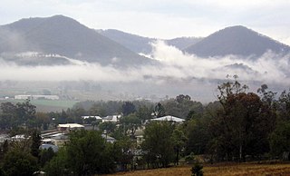
Rathdowney is a rural town and locality in the Scenic Rim Region, Queensland, Australia. In the 2016 census, Rathdowney had a population of 308 people.

<span class="mw-page-title-main">Killarney, Queensland</span> Town in Queensland, Australia

Killarney is a rural town and locality in the Southern Downs Region, Queensland, Australia. It borders New South Wales. In the 2016 census, the locality of Killarney had a population of 954 people.

<span class="mw-page-title-main">Mount Moon</span>

Mount Moon is a lightly timbered, dome-shaped mountain in the Scenic Rim, Queensland, Australia. Its Indigenous name is Kibbobum. The mountain rises 784 metres (2,572 ft) above sea level and is part of the Teviot Range and is within the Moogerah Peaks National Park. It is within the locality of Croftby in the Scenic Rim Region local government area.

<span class="mw-page-title-main">Dugandan, Queensland</span> Suburb of Boonah, Queensland, Australia

Dugandan is a rural town and locality in the Scenic Rim Region, Queensland, Australia. In the 2016 census, Dugandan had a population of 593 people.

Undullah is a rural locality split between the City of Logan and the Scenic Rim Region, Queensland, Australia. In the 2016 census, Undullah had a population of 45 people.

<span class="mw-page-title-main">Palen Creek, Queensland</span> Suburb of Scenic Rim Region, Queensland, Australia

Palen Creek is a rural locality in the Scenic Rim Region, Queensland, Australia. It borders New South Wales. In the 2016 census, Palen Creek had a population of 280 people.

<span class="mw-page-title-main">Oaky Creek, Queensland</span> Suburb of Scenic Rim Region, Queensland, Australia

Oaky Creek is a rural locality in the Scenic Rim Region, Queensland, Australia. In the 2016 census Oaky Creek had a population of 83 people.

<span class="mw-page-title-main">Running Creek, Queensland</span> Suburb of Scenic Rim Region, Queensland, Australia

Running Creek is a rural locality in the Scenic Rim Region, Queensland, Australia. In the 2016 census, Running Creek had a population of 147 people. It borders New South Wales.

<span class="mw-page-title-main">Knapp Creek, Queensland</span> Suburb of Scenic Rim Region, Queensland, Australia

Knapp Creek is a rural locality in the Scenic Rim Region, Queensland, Australia. In the 2016 census, Knapp Creek had a population of 59 people.

<span class="mw-page-title-main">Mount French, Queensland</span> Suburb of Scenic Rim Region, Queensland, Australia

Mount French is a rural locality in the Scenic Rim Region, Queensland, Australia. In the 2016 census, Mount French had a population of 94 people.

<span class="mw-page-title-main">Bunjurgen, Queensland</span> Suburb of Scenic Rim Region, Queensland, Australia

Bunjurgen is a rural locality in the Scenic Rim Region, Queensland, Australia. In the 2016 census, Bunjurgen had a population of 116 people.

<span class="mw-page-title-main">Moogerah, Queensland</span> Suburb of Scenic Rim Region, Queensland, Australia

Moogerah is a rural locality in the Scenic Rim Region, Queensland, Australia. In the 2016 census, Moogerah had a population of 234 people.

Croftby is a rural locality in the Scenic Rim Region, Queensland, Australia. In the 2016 census, Croftby had a population of 133 people. The town of Teviot is within the locality.

<span class="mw-page-title-main">Clumber, Queensland</span> Suburb of Scenic Rim Region, Queensland, Australia

Clumber is a rural locality in the Scenic Rim Region, Queensland, Australia. In the 2016 census, Clumber had a population of 60 people.

<span class="mw-page-title-main">Mount Edwards, Queensland</span> Suburb of Scenic Rim Region, Queensland, Australia

Mount Edwards is a rural locality in the Scenic Rim Region, Queensland, Australia. In the 2016 census, Mount Edwards had a population of 63 people.

Burnett Creek is a rural locality in the Scenic Rim Region, Queensland, Australia. In the 2016 census, Burnett Creek had a population of 11 people. It borders New South Wales to the south.

<span class="mw-page-title-main">Frenches Creek, Queensland</span> Suburb of Scenic Rim Region, Queensland, Australia

Frenches Creek is a rural locality in the Scenic Rim Region, Queensland, Australia. In the 2016 census, Frenches Creek had a population of 85 people.

Wallaces Creek is a rural locality in the Scenic Rim Region, Queensland, Australia. In the 2016 census, Wallaces Creek had a population of 58 people.

The Head is a rural locality in the Southern Downs Region, Queensland, Australia. It borders New South Wales. In the 2016 census, The Head had a population of 7 people.

Teviot Range is a mountain range in the Scenic Rim Region, Queensland, Australia.

References

  1. 1 2 3 4 Australian Bureau of Statistics (27 June 2017). "Carneys Creek (SSC)". 2016 Census QuickStats. Retrieved 20 October 2018. OOjs UI icon edit-ltr-progressive.svg
  2. 1 2 "Carneys Creek – locality in Scenic Rim Region (entry 46151)". Queensland Place Names. Queensland Government . Retrieved 29 December 2020.
  3. 1 2 3 4 5 "Queensland Globe". State of Queensland . Retrieved 12 August 2021.
  4. 1 2 "Carneys Creek – watercourse in Scenic Rim Regional (entry 6300)". Queensland Place Names. Queensland Government . Retrieved 29 December 2020.
  5. 1 2 3 4 5 "Mountain peaks and capes - Queensland". Queensland Open Data. Queensland Government. 12 November 2020. Archived from the original on 25 November 2020. Retrieved 25 November 2020.
  6. "Mount Roberts – mountain in Scenic Rim Region (entry 28582)". Queensland Place Names. Queensland Government . Retrieved 25 November 2020.
  7. "Mount Superbus – mountain in Scenic Rim Region (entry 32867)". Queensland Place Names. Queensland Government . Retrieved 25 November 2020.
  8. "Toowoonan Mount – mountain in Scenic Rim Region (entry 34976)". Queensland Place Names. Queensland Government . Retrieved 25 November 2020.
  9. "Wilsons Peak – mountain in Scenic Rim Region (entry 37623)". Queensland Place Names. Queensland Government . Retrieved 25 November 2020.
  10. "TOOLOOM DIGGINGS". The Moreton Bay Courier . Vol. XIV, no. 781. Queensland, Australia. 7 September 1859. p. 3. Archived from the original on 3 May 2021. Retrieved 3 May 2021 via National Library of Australia.
  11. "Advertising". The North Australian, Ipswich And General Advertiser . Vol. V, no. 215. Queensland, Australia. 8 November 1859. p. 1. Archived from the original on 3 May 2021. Retrieved 3 May 2021 via National Library of Australia.
  12. Queensland Family History Society (2010), Queensland schools past and present (Version 1.01 ed.), Queensland Family History Society, ISBN   978-1-921171-26-0
  13. "Moreton 40 Chain map AG2 series sheet 26 south" (Map). Queensland Government. 1926. Archived from the original on 12 August 2021. Retrieved 12 August 2021.
  14. "Queensland Two Mile series sheet 2m38" (Map). Queensland Government. 1946. Archived from the original on 8 June 2020. Retrieved 12 August 2021.