Emu Vale, Queensland

Last updated

Map all coordinates using: OpenStreetMap
Emu Vale
Queensland
Queensland State Archives 5179 Maize and Wheat Crops Emu Vale c 1899.png
Maize and Wheat Crops, Emu Val, circa 1899
Australia Queensland location map.svg
Red pog.svg
Emu Vale
Coordinates 28°13′44″S152°14′56″E / 28.2288°S 152.2488°E / -28.2288; 152.2488 (Emu Vale (town centre))
Population161 (SAL 2021) [1]
Postcode(s) 4371
Area163.5 km2 (63.1 sq mi)
Time zone AEST (UTC+10:00)
Location
LGA(s) Southern Downs Region
State electorate(s) Southern Downs
Federal division(s) Maranoa
Localities around Emu Vale:
Yangan Swanfels Clumber
Junabee
Danderoo
Emu Vale Moogerah
Tannymorel Mount Colliery Carneys Creek

Emu Vale is a rural town and locality in the Southern Downs Region, Queensland, Australia. [2] [3] In the 2021 census, the locality of Emu Vale had a population of 161 people. [4]

Contents

Geography

The locality is bounded to the east by the Main Range section of the Great Dividing Range. The terrain is mountainous with elevations ranging from 490 to 1,360 metres (1,610 to 4,460 ft) above sea level. [5] There are a number of named peaks (from north to south):

The Steamers are distinctive rock formations, which are thought to be from a thick trachyte lava flow from the Main Range volcano which was active 24 million years ago. They look like an old steamship with four high protruding peaks representing its Stern, Prow, Funnel and Mast. [12] [13]

Most of the north-east of the locality is within the Main Range National Park. Apart from this protected area, the land use is mostly crop growing in the south-east (the lower flatter area around the town) and grazing on native vegetation elsewhere. [5]

History

The town takes its name from the Emu Vale railway station on the Killarney railway line, which is believed to be named after an early pastoral run. [2]

A sawmill was established on 5 acres (2.0 ha) of land at Upper Emu Creek byJames McAra, George Hall, Thomas Hall and William Hall. It was operating by April 1873. [14]

Emu Vale Provisional School opened on 2 February 1876. It became Emu Vale State School on 20 January 1879. It was closed on 31 December 2003. [15] [16] The school was located on the triangle land parcel on the north-west corner of Yangan Killarney Road and Emu Creek Road ( 28°13′25″S152°14′52″E / 28.2237°S 152.2479°E / -28.2237; 152.2479 (Emu Vale State School (former)) ). [17] The school site was then split into two sections with the western part becoming Emu Vale Park and the eastern part with the former school buildings now being used as holiday accommodation. [18] [19] The school's website was archived. [20]

Land in Emu Vale was open for selection on 17 April 1877; 75 square miles (190 km2) were available. [21]

Emu Vale railway station, ca. 1890 Emu Vale railway station, ca. 1890.jpg
Emu Vale railway station, ca. 1890

The first section of the Killarney railway line from Warwick was 24 kilometres (15 mi) long and terminated at Emu Vale. The contract to build the first section was given to John Garget on 22 November 1881, but progress was delayed when the Queensland Railway Department was unable to provide the locomotives and wagons need to carry the construction materials. The first section to Emu Vale railway station opened on 2 June 1884. It was officially opened with a train from Warwick decorated with flags and greenery with several hundred passengers on board. The second section of the railway from Emu Vale to Killarney railway station was also built by Garget and completed on 22 August 1885. [22]

In 1898, the Post and Telegraph and Postal Note Office previously known as Neereeadah was changed to Emu Vale. [23]

In 1911, A. and D. Munro established a sawmill beside Emu Creek at the confluence of its north and south branches. The mill closed two years later. [14]

Rocky Mountain Provisional School opened on 1919 and closed circa 1920. [24] It was on Emu Creek Road (approx 28°12′29″S152°21′57″E / 28.2080°S 152.3658°E / -28.2080; 152.3658 (Rocky Mountain State School (former)) ). [25] [26]

Boldery and Brett built a sawmill in 1928 near the confluence of Emu Creek and Emu Creek South ( 28°12′37″S152°23′50″E / 28.2103°S 152.39715°E / -28.2103; 152.39715 (Boldery and Brett sawmill (former)) ). [27] [28] Following some changes in ownership, the sawmill closed in 1968. [14]

By 1931, the Holy Redeemer Catholic Church had been established. [29]

Emu Creek Upper Provisional School opened on 23 February 1942 in conjunction with the sawmill built by Boldery and Brett. [14] It closed in 1956 but reopened in 1957. It closed permanently in 1960. [15] It was on the northern side of Emu Creek Road (approx 28°12′41″S152°23′52″E / 28.2114°S 152.3977°E / -28.2114; 152.3977 (Upper Emu Creek Provisional School (former)) ). A plaque was placed at the school's location on 26 March 2005 by Alan Barclay Skinner, the last teacher at the school. [30] [31]

The Emu Vale Memorial Hall was officially opened on Saturday 28 May 1954 by Sir Raymond Huish. [32] [33]

Demographics

In the 2016 census, the locality of Emu Vale had a population of 185 people. [34]

In the 2021 census, the locality of Emu Vale had a population of 161 people. [4]

Education

There are no schools in Emu Vale. The nearest government primary school is Yangan State School in neighbouring Yangan to the north-east. The nearest government secondary schools are Killarney State School (to Year 10) in Killarney to the south and Warwick State High School in Warwick to the west. [35]

Community groups

The Emu Vale branch of the Queensland Country Women's Association meets at the Emu Vale Memorial Hall at 559 Yangan Killarney Road ( 28°13′47″S152°14′51″E / 28.2297°S 152.2474°E / -28.2297; 152.2474 (Emu Vale Memorial Hall) ). [36]

Related Research Articles

<span class="mw-page-title-main">Killarney, Queensland</span> Town in Queensland, Australia

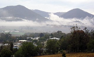
Killarney is a rural town and locality in the Southern Downs Region, Queensland, Australia. It borders New South Wales. In the 2016 census, the locality of Killarney had a population of 954 people.

<span class="mw-page-title-main">Southern Downs Region</span> Local government area in Queensland, Australia

The Southern Downs Region is a local government area in the Darling Downs region of Queensland, Australia, along the state's boundary with New South Wales. It was created in 2008 from a merger of the Shire of Warwick and the Shire of Stanthorpe.

<span class="mw-page-title-main">Killarney railway line</span> Former railway line in Queensland

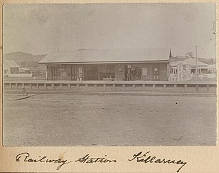
The Killarney railway line was a branch railway in the Darling Downs region of Queensland, Australia. It travelled from Warwick to Killarney and operated from 1884 to 1964.

<span class="mw-page-title-main">Swan Creek, Queensland</span> Suburb of Southern Downs Region, Queensland, Australia

Swan Creek is a rural locality in the Southern Downs Region, Queensland, Australia. In the 2021 census, Swan Creek had a population of 161 people.

<span class="mw-page-title-main">Yangan, Queensland</span> Town in Queensland, Australia

Yangan is a rural town and locality in the Southern Downs Region, Queensland, Australia. In the 2021 census, the locality of Yangan had a population of 404 people.

<span class="mw-page-title-main">Colinton, Queensland</span> Suburb of Somerset Region, Queensland, Australia

Colinton is a rural locality in the Somerset Region, Queensland, Australia. In the 2016 census, Colinton had a population of 75 people.

<span class="mw-page-title-main">Mount Mort, Queensland</span> Suburb of Ipswich, Queensland, Australia

Mount Mort is a rural locality in the City of Ipswich, Queensland, Australia. In the 2021 census, Mount Mort had a population of 78 people.

<span class="mw-page-title-main">Mount Gipps, Queensland</span> Suburb of Scenic Rim Region, Queensland, Australia

Mount Gipps is a rural locality in the Scenic Rim Region, Queensland, Australia. In the 2016 census, Mount Gipps had a population of 7 people.

<span class="mw-page-title-main">Tannymorel, Queensland</span> Town in Queensland, Australia

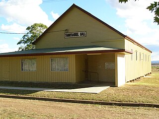
Tannymorel is a rural town and locality in the Southern Downs Region, Queensland, Australia. In the 2016 census, the locality of Tannymorel had a population of 161 people.

<span class="mw-page-title-main">Freestone, Queensland</span> Town in Queensland, Australia

Freestone is a rural town and locality in the Southern Downs Region, Queensland, Australia. In the 2016 census, Freestone had a population of 217 people.

<span class="mw-page-title-main">Carneys Creek, Queensland</span> Rural locality in Queensland, Australia

Carneys Creek is a rural locality in the Scenic Rim Region, Queensland, Australia. In the 2016 census, Carneys Creek had a population of 51 people. It borders New South Wales.

<span class="mw-page-title-main">Clintonvale, Queensland</span> Suburb of Southern Downs Region, Queensland, Australia

Clintonvale is a rural locality in the Southern Downs Region, Queensland, Australia. In the 2016 census, Clintonvale had a population of 74 people.

<span class="mw-page-title-main">Upper Freestone, Queensland</span> Suburb of Southern Downs Region, Queensland, Australia

Upper Freestone is a rural locality in the Southern Downs Region, Queensland, Australia. In the 2016 census, Upper Freestone had a population of 90 people.

<span class="mw-page-title-main">Junabee</span> Suburb of Southern Downs Region, Queensland, Australia

Junabee is a rural locality in the Southern Downs Region, Queensland, Australia. In the 2016 census, Junabee had a population of 213 people.

The Hermitage is a rural locality in the Southern Downs Region, Queensland, Australia. In the 2021 census, The Hermitage had a population of 55 people. There is a large agricultural research facility in the locality.

<span class="mw-page-title-main">Leslie Dam, Queensland</span> Suburb of Southern Downs Region, Queensland, Australia

Leslie Dam is a locality in the Southern Downs Region, Queensland, Australia. In the 2021 census, Leslie Dam had a population of 118 people.

The Head is a rural locality in the Southern Downs Region, Queensland, Australia. It borders New South Wales. In the 2021 census, The Head had a population of 12 people.

<span class="mw-page-title-main">Silverwood, Queensland</span> Suburb of Southern Downs Region, Queensland, Australia

Silverwood is a rural locality in the Southern Downs Region, Queensland, Australia. In the 2021 census, Silverwood had a population of 58 people.

Mount Sturt is a rural locality in the Southern Downs Region, Queensland, Australia. In the 2021 census, Mount Sturt had a population of 14 people.

Emu Creek is a rural locality in the Toowoomba Region, Queensland, Australia. In the 2021 census, Emu Creek had a population of 113 people.

References

  1. Australian Bureau of Statistics (28 June 2022). "Emu Vale (suburb and locality)". Australian Census 2021 QuickStats. Retrieved 28 June 2022.  OOjs UI icon edit-ltr-progressive.svg
  2. 1 2 "Emu Vale – town in Southern Downs Region (entry 11733)". Queensland Place Names. Queensland Government . Retrieved 13 June 2020.
  3. "Emu Vale – locality in Southern Downs Region (entry 45925)". Queensland Place Names. Queensland Government . Retrieved 13 June 2020.
  4. 1 2 Australian Bureau of Statistics (28 June 2022). "Emu Vale (SAL)". 2021 Census QuickStats. Retrieved 28 February 2023. OOjs UI icon edit-ltr-progressive.svg
  5. 1 2 "Queensland Globe". State of Queensland . Retrieved 3 February 2024.
  6. 1 2 3 4 5 6 7 8 9 10 11 "Mountain peaks and capes - Queensland". Queensland Open Data. Queensland Government. 12 November 2020. Archived from the original on 25 November 2020. Retrieved 25 November 2020.
  7. "Mount Huntley – mountain in Southern Downs Region (entry 16502)". Queensland Place Names. Queensland Government . Retrieved 25 November 2020.
  8. "Mount Bauer – mountain in Southern Downs Region (entry 1878)". Queensland Place Names. Queensland Government . Retrieved 25 November 2020.
  9. "Mount Guymer – mountain in Southern Downs Region (entry 15130)". Queensland Place Names. Queensland Government . Retrieved 25 November 2020.
  10. "Mount Steamer – mountain in Southern Downs Region (entry 32314)". Queensland Place Names. Queensland Government . Retrieved 25 November 2020.
  11. "Hoffmans Peak – mountain in Southern Downs Region (entry 15976)". Queensland Place Names. Queensland Government . Retrieved 25 November 2020.
  12. "What mountain is that? The Steamers". Visit Scenic Rim. Archived from the original on 3 February 2024. Retrieved 3 February 2024.
  13. "Nature, culture and history | Main Range National Park". Parks and forests. Queensland Government. 7 June 2006. Archived from the original on 28 November 2023. Retrieved 3 February 2024.
  14. 1 2 3 4 Kerr, John (January 1998). "Forest industry heritage places study : sawmills and tramways South Eastern Queensland" (PDF). Australian Government (published 1998). p. 211. Archived (PDF) from the original on 15 May 2021. Retrieved 4 February 2024.
  15. 1 2 Queensland Family History Society (2010), Queensland schools past and present (Version 1.01 ed.), Queensland Family History Society, ISBN   978-1-921171-26-0
  16. "Queensland state school - centre closures" (PDF). Queensland Government . 20 August 2013. Archived (PDF) from the original on 20 March 2022. Retrieved 7 April 2022.
  17. "9341-42 Yangan". Queensland Government. 1983. Retrieved 3 February 2024.
  18. "Former Vale schoolyard finally recognised". Warwick Daily News . 9 September 2014. Archived from the original on 3 February 2024. Retrieved 3 February 2024.
  19. "Country school". Stayz . Archived from the original on 3 February 2024. Retrieved 3 February 2024.
  20. "Home Page". Emu Vale State School. 17 July 2005. Archived from the original on 17 July 2005. Retrieved 23 April 2022.
  21. "Proclamations under the New Land Acts". The Brisbane Courier . Queensland, Australia. 2 March 1877. p. 3. Archived from the original on 27 August 2020. Retrieved 19 February 2020 via Trove.
  22. Kerr, John (1990). Triumph of narrow gauge : a history of Queensland Railways. Boolarong Publications. pp. 59–60. ISBN   978-0-86439-102-5.
  23. "CHANGE OF NAME". Warwick Examiner And Times . Vol. 32, no. 4271. Queensland, Australia. 19 October 1898. p. 3. Retrieved 2 February 2023 via National Library of Australia.
  24. Queensland Family History Society (2010), Queensland schools past and present (Version 1.01 ed.), Queensland Family History Society, ISBN   978-1-921171-26-0
  25. "Parish of Emu Vale" (Map). Queensland Government. 1930. Retrieved 4 February 2024.
  26. "Queensland Globe". State of Queensland . Retrieved 4 February 2024.
  27. "SAWMILLING AT EMU VALE". Warwick Daily News . No. 2828. Queensland, Australia. 17 July 1928. p. 2. Retrieved 4 February 2024 via National Library of Australia.
  28. Google (4 February 2024). "Upper Emu Creek Old Saw Mill Site" (Map). Google Maps . Google. Retrieved 4 February 2024.
  29. "TANNYMOREL PRESBYTERY". Warwick Daily News . No. 3604. Queensland, Australia. 21 January 1931. p. 2. Retrieved 10 September 2021 via National Library of Australia.
  30. "Queensland Two Mile series sheet 2m41" (Map). Queensland Government. 1955. Retrieved 3 February 2024.
  31. Google (3 February 2024). "Old Upper Emu Creek School" (Map). Google Maps . Google. Retrieved 3 February 2024.
  32. "Advertising". Warwick Daily News . No. 10, 836. Queensland, Australia. 6 May 1954. p. 2. Retrieved 1 September 2020 via National Library of Australia.
  33. "War Memorial Hall for Emu Vale". Warwick Daily News . No. 10, 449. Queensland, Australia. 4 February 1953. p. 2. Retrieved 1 September 2020 via National Library of Australia.
  34. Australian Bureau of Statistics (27 June 2017). "Emu Vale (SSC)". 2016 Census QuickStats. Retrieved 20 October 2018. OOjs UI icon edit-ltr-progressive.svg
  35. "Layers: Locality; Schools and school catchments". Queensland Globe. Queensland Government. Archived from the original on 19 December 2017. Retrieved 3 February 2024.
  36. "Emu Vale Branch". Queensland Country Women's Association. Archived from the original on 1 September 2020. Retrieved 1 September 2020.