Killarney railway line

Last updated

Contents

Killarney railway line
BSicon exKBHFa.svg
45km
Killarney
BSicon exHST.svg
39km
Graysons Siding
BSicon exHST.svg
37km
Tannymorel
BSicon uexKDSTa.svg
BSicon exSTR.svg
42km
Mount Colliery Tramway
BSicon uexSTRl.svg
BSicon exmABZgr.svg
BSicon exHST.svg
33km
Wiyarra
BSicon exHST.svg
31km
Danderoo
BSicon exHST.svg
26km
Emu Vale
BSicon exHST.svg
22km
Rockbrae
BSicon exHST.svg
20km
Yangan
BSicon exHST.svg
16km
Mount Sturt
BSicon exHST.svg
13km
Karcaruda
BSicon exHST.svg
12km
Swan Creek
BSicon exHST.svg
10km
Glencairn
BSicon exHST.svg
8km
Hermitage
BSicon CONTgq.svg
BSicon eABZql.svg
BSicon CONTfq.svg
0km
Southern Line from Warwick

The Killarney railway line was a branch railway in the Darling Downs region of Queensland, Australia. It travelled from Warwick to Killarney and operated from 1884 to 1964.

Killarney railway station, c. 1905 StateLibQld 1 241267 Killarney Railway Station.jpg
Killarney railway station, c.1905

Along with approval for the Fassifern and Crows Nest branches in 1880 came parliamentary approval for this branch. Although the owner of the large Canning Downs station offered land to enable a direct route from Warwick to Killarney, a more circuitous route was chosen to serve surrounding farms. It meant that the branch line ran 44 kilometres east from Warwick and then south to Killarney rather than take a direct 32 kilometre route through Canning Downs. [1]

The Southern railway line reached Warwick in 1871. The terminus was then on the northern side of the Condamine River. After construction of a bridge over the river and extension of the line south to Stanthorpe, a stop at East Warwick became Warwick railway station and the old terminus was renamed Mill Hill railway station. The branch line to Killarney left the Southern Line a little beyond Mill Hill at what was called Killarney Junction.

Swan Creek railway station, 1911 Swan Creek railway station, 1911.jpg
Swan Creek railway station, 1911

The Killarney branch opened as far as Emu Vale on 2 June 1884 and then to Killarney on 24 August 1885. [2] Sidings for the first stage were located at Hermitage, Glencairn, Swan Creek, Karcaruda, Mount Sturt, Yangan and Rockbrae whilst in the second stage Danderoo, Wiyarra, Tannymorel ( 28°17′27″S152°14′51″E / 28.2907°S 152.2474°E / -28.2907; 152.2474 (Tannymorel railway station) ) [3] and Grayson ( 28°18′15″S152°15′25″E / 28.3042°S 152.2570°E / -28.3042; 152.2570 (Grayson railway station) ) [4] were stops.

For the duration of the branch, a train ran six days a week. Grain traffic and cheese from a Yangan factory constituted its major cargo and, after the discovery of coal at Mount Colliery east of Tannymorel, it too contributed greatly to the profitability of the line. From 1930, a railmotor operated the run. The Mount Colliery Tramway, a private 5 km-long horse tramway, opened in 1908. The tramway joined the line at Tannymorel to transport coal from a nearby mine to the railway. [2]

The Killarney line, together with the colliery tramway, closed on 1 May 1964. [2]

See also

Related Research Articles

<span class="mw-page-title-main">Killarney, Queensland</span> Town in Queensland, Australia

Killarney is a rural town and locality in the Southern Downs Region, Queensland, Australia. It borders New South Wales. In the 2016 census, the locality of Killarney had a population of 954 people.

The Maryvale railway line was a branch railway in the Southern Downs region of Queensland, Australia.

<span class="mw-page-title-main">Southern railway line</span> Railway line in Queensland, Australia

The Southern railway line serves the Darling Downs region of Queensland, Australia. The 197-kilometre (122 mi) long line branches from the Western line at Toowoomba, 161 kilometres (100 mi) west of Brisbane, and proceeds south through Warwick and Stanthorpe to the New South Wales/Queensland state border at Wallangarra.

<span class="mw-page-title-main">Maryvale, Queensland (Southern Downs Region)</span> Town in Queensland, Australia

Maryvale is a rural town and locality in the Southern Downs Region, Queensland, Australia. In the 2016 census, the locality of Maryvale had a population of 303 people.

The Mount Edwards railway line was a branch railway in the Scenic Rim region of South East Queensland, Australia. The lines serves a number of small towns in the Fassifern Valley. The first stage of the Mount Edwards line opened from Munbilla to Engelsburg on 17 April 1916, but the next stage to Mount Edwards was not completed until 7 October 1922. The line closed on 1 November 1960.

<span class="mw-page-title-main">Construction of Queensland railways</span>

Queensland's railway construction commenced in 1864, with the turning of the first sod of the Main Line by Lady Diamantina Bowen, the wife of Queensland's first governor Sir George Bowen at Ipswich, Queensland, Australia. A narrow gauge of 3 ft 6 in was selected due to cost savings in providing a rail link to Toowoomba. Despite being built with bridges wide enough for standard gauge, and the fact that most other lines did not require heavy earthworks, the gauge remained the Queensland system norm.

<span class="mw-page-title-main">Swan Creek, Queensland</span> Suburb of Southern Downs Region, Queensland, Australia

Swan Creek is a rural locality in the Southern Downs Region, Queensland, Australia. In the 2016 census, Swan Creek had a population of 139 people.

<span class="mw-page-title-main">Yangan, Queensland</span> Town in Queensland, Australia

Yangan is a rural town and locality in the Southern Downs Region, Queensland, Australia. In the 2016 census, Yangan had a population of 386 people.

<span class="mw-page-title-main">Western railway line, Queensland</span> Railway line in Queensland, Australia

The Western railway line is a narrow gauge railway, connecting the south-east and south-west regions of Queensland, Australia. It commences at Toowoomba, at the end of the Main Line railway from Brisbane, and extends west 810 km to Cunnamulla, passing through the major towns of Dalby, Roma and Charleville, although services on the 184 km section from Westgate to Cunnamulla have been suspended since 2011. The Queensland Government was the first railway operator in the world to adopt narrow gauge for a main line, and this remains the system-wide gauge.

<span class="mw-page-title-main">Yangan Masonic Hall</span> Historic site in Queensland, Australia

Yangan Masonic Hall is a heritage-listed masonic hall at 36 King Street, Yangan, Southern Downs Region, Queensland, Australia. It was built from 1898 to 1957. It is also known as Yangan Masonic Temple and was formerly the Yangan School of Arts. It was added to the Queensland Heritage Register on 21 October 1992.

<span class="mw-page-title-main">Yangan School of Arts</span> Historic site in Queensland, Australia

Yangan School of Arts is a heritage-listed school of arts at 7-9 King Street, Yangan, Southern Downs Region, Queensland, Australia. It was built in 1912. It was added to the Queensland Heritage Register on 21 October 1992.

<span class="mw-page-title-main">Tannymorel, Queensland</span> Town in Queensland, Australia

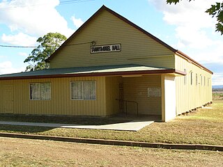
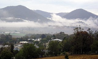
Tannymorel is a rural town and locality in the Southern Downs Region, Queensland, Australia. In the 2016 census, the locality of Tannymorel had a population of 161 people.

<span class="mw-page-title-main">Clintonvale, Queensland</span> Suburb of Southern Downs Region, Queensland, Australia

Clintonvale is a rural locality in the Southern Downs Region, Queensland, Australia. In the 2016 census, Clintonvale had a population of 74 people.

Danderoo is a rural locality in the Southern Downs Region, Queensland, Australia. In the 2016 census, Danderoo had a population of 30 people.

Elbow Valley is a rural locality in the Southern Downs Region, Queensland, Australia. It is on the border of New South Wales. In the 2016 census, Elbow Valley had a population of 95 people.

<span class="mw-page-title-main">Emu Vale, Queensland</span> Town in Queensland, Australia

Emu Vale is a rural town and locality in the Southern Downs Region, Queensland, Australia. In the 2016 census, Emu Vale had a population of 185 people.

<span class="mw-page-title-main">Upper Freestone, Queensland</span> Suburb of Southern Downs Region, Queensland, Australia

Upper Freestone is a rural locality in the Southern Downs Region, Queensland, Australia. In the 2016 census, Upper Freestone had a population of 90 people.

<span class="mw-page-title-main">Mount Colliery, Queensland</span> Suburb of Southern Downs Region, Queensland, Australia

Mount Colliery is a rural locality in the Southern Downs Region, Queensland, Australia. In the 2016 census, Mount Colliery had a population of 111 people.

<span class="mw-page-title-main">Junabee</span> Suburb of Southern Downs Region, Queensland, Australia

Junabee is a rural locality in the Southern Downs Region, Queensland, Australia. In the 2016 census, Junabee had a population of 213 people.

Loch Lomond is a rural locality in the Southern Downs Region, Queensland, Australia. In the 2016 census, Loch Lomond had a population of 106 people.

References

  1. "Triumph of Narrow Gauge: A History of Queensland Railways" by John Kerr 1990 Boolarong Press, Brisbane
  2. 1 2 3 Southern Downs Steam Railway (2008). "Historical information: Warwick – Killarney". Archived from the original on 12 September 2009. Retrieved 17 November 2008.
  3. "Town of Tannymorel" (Map). Queensland Government. 1948. Retrieved 18 March 2021.
  4. "Parish of Cunningham" (Map). Queensland Government. 1949. Retrieved 18 March 2021.