Callide Valley railway line

Last updated

Map all coordinates using: OpenStreetMap

The Callide Valley railway line ran from Rannes to Lawgi in Queensland, Australia. The Callide Valley lies to the south-west of Rockhampton in Central Queensland.

Contents

History

There were grand plans to link Monto by railway with the south, east and north. Links with Maryborough to the south and Gladstone to the east materialised but the northern link terminated at Lawgi some 70 kilometres away. Rannes was already linked by rail to Rockhampton by the Dawson Valley railway line via Mount Morgan and a branch line from Rannes to Lawgi provided access to the rich Callide Valley and justified its construction.

Opening

The first stage commenced from Rannes, heading south-east to Callide (originally called Callidi) and opened on 3 May 1924. Stops en route were Jooro, Goovigen, Jambin and Argoon. A mixed train ran twice a week from Baralaba, west of Rannes on the Dawson Valley branch, to Callide and connected at Rannes with a service northeast to Rockhampton. A 22 kilometre extension was opened on 24 August 1925 south from Callide via Biloela to Thangool which at the time was the main township between Rannes and Monto.

Train services

A mixed service took 7½ hours for the journey from Thangool to Mount Morgan and a later passenger service took 6 hours from Thangool to Rockhampton. The terminus at Thangool was intended to be temporary and trucking yards were not constructed. However, facilities were provided at Biloela siding and it quickly became the major centre of the district.

Later stages

Construction beyond Thangool was halted in August 1926 and resumed during the depression as an employment creation measure. The third and final stage took the line a further 14 kilometres via Mount Scoria to Lawgi. Proposed construction to Monto did not eventuate and isolated Lawgi became the terminus on 19 September 1932. The Lawgi station mistress was withdrawn in 1952 and the section to Thangool was closed on 1 July 1955. The Thangool to Biloela section closed on 31 January 1988 and Biloela became the railhead. The line between Biloela and Lawgi was taken up. It remains in place between Rannes and Biloela, though only the section between Dakenba and Earlsfield is in service.

A 1939 map shows the proposed railway beyond Lawgi with the following planned railway stations: [1]

Timeline

Moura Short Line

In 1968 the Moura Short Line was opened to transport coal from the Callide and Moura mines to Gladstone port. [2] The line crosses the Callide branch line between Jambin and Callide at Earlsfield Junction and thus links Biloela with Gladstone in lieu of its previous link to Rockhampton.

Route

Callide Valley railway line
Distance from RockhamptonStationsPresent localityCoordinatesAltitudeNotes
66 miles 52 chains (107.3 km) Rannes Goovigen, Shire of Banana 24°06′13″S150°07′06″E / 24.10350°S 150.11820°E / -24.10350; 150.11820 (Rannes railway station (former)) 327 feet (100 m) [3] [4]
72 miles 79 chains (117.5 km) Jooro Goovigen, Shire of Banana 24°06′52″S150°12′41″E / 24.11454°S 150.21150°E / -24.11454; 150.21150 (Jooro railway station (former)) 483 feet (147 m) [5] [4]
78 miles 20 chains (125.9 km) Goovigen Goovigen, Shire of Banana 24°08′47″S150°17′02″E / 24.14644°S 150.28398°E / -24.14644; 150.28398 (Goovigen railway station (former)) 425 feet (130 m) [6] [4]
84 miles 52 chains (136.2 km) Jambin Jambin, Shire of Banana 24°11′44″S150°22′11″E / 24.19550°S 150.36970°E / -24.19550; 150.36970 (Jambin railway station (former)) 435 feet (133 m) [6] [4]
90 miles 40 chains (145.6 km) Argoon Jambin, Shire of Banana 24°15′15″S150°26′01″E / 24.25411°S 150.43361°E / -24.25411; 150.43361 (Argoon railway station (former)) 509 feet (155 m) [7] [4]
94 miles 30 chains (151.9 km) Callide Callide, Shire of Banana 24°18′06″S150°30′31″E / 24.30175°S 150.50867°E / -24.30175; 150.50867 (Callide railway station (former)) 518 feet (158 m) [7] [4]
102 miles 07 chains (164.3 km) Biloela Biloela, Shire of Banana 24°23′58″S150°30′31″E / 24.39949°S 150.50867°E / -24.39949; 150.50867 (Biloela railway station (former)) 577 feet (176 m) [7] [4]
109 miles 21 chains (175.8 km) Thangool Thangool, Shire of Banana 24°29′11″S150°34′37″E / 24.48650°S 150.57682°E / -24.48650; 150.57682 (Thangool railway station (former)) 652 feet (199 m) [7] [4]
110 miles 72 chains (178.5 km) Kariboe Thangool, Shire of Banana 24°29′57″S150°35′45″E / 24.49903°S 150.59572°E / -24.49903; 150.59572 (Kariboe railway station (former)) 650 feet (200 m) [7] [4]
113 miles 60 chains (183.1 km) Mount Scoria Thangool, Shire of Banana 24°32′04″S150°36′58″E / 24.53451°S 150.61619°E / -24.53451; 150.61619 (Mount Scoria railway station (former)) 687 feet (209 m) [7] [4]
117 miles 55 chains (189.4 km) Lawgi Lawgi Dawes, Shire of Banana924 feet (282 m) [7]

See also

Related Research Articles

<span class="mw-page-title-main">Biloela</span> Town in Queensland, Australia

Biloela is a rural town and locality in the Shire of Banana, Central Queensland, Australia. It is situated 120 kilometres (75 mi) inland from the port city of Gladstone at the junction of the Burnett and Dawson highways. Biloela is the administrative centre of Banana Shire, which has an area of 15,729 square kilometres (6,073 sq mi). In the 2021 census, the locality of Biloela had a population of 5,692 people.

<span class="mw-page-title-main">Burnett Highway</span> Highway in Queensland, Australia

The Burnett Highway is an inland rural highway located in Queensland, Australia. The highway runs between its junction with the Bruce Highway at Gracemere, just south of Rockhampton, and Nanango. Its length is approximately 542 kilometres. The highway takes its name from the Burnett River, which it crosses in Gayndah. The Burnett Highway provides the most direct link between the northern end of the New England Highway and Rockhampton. It is designated as a State Strategic Road by the Queensland Government.

<span class="mw-page-title-main">Thangool</span> Town in Queensland, Australia

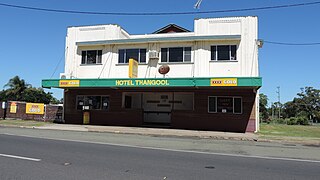
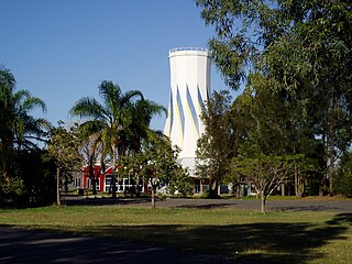
Thangool is a rural town and locality in the Shire of Banana, Queensland, Australia. In the 2016 census, the locality of Thangool had a population of 741 people.

<span class="mw-page-title-main">Goovigen</span> Town in Queensland, Australia

Goovigen is a rural town and locality in the Shire of Banana, Queensland, Australia. In the 2016 census, the locality of Goovigen had a population of 215 people.

<span class="mw-page-title-main">Wowan, Queensland</span> Town in Queensland, Australia

Wowan is a rural town and locality in the Shire of Banana, Queensland, Australia. In the 2016 census, the locality of Wowan had a population of 216 people.

<span class="mw-page-title-main">Rannes, Queensland</span> Town in Queensland, Australia

Rannes is a rural town in the west of the locality of Goovigen in the Shire of Banana, Queensland, Australia.

<span class="mw-page-title-main">Jambin, Queensland</span> Town in Queensland, Australia

Jambin is a rural town and locality in the Shire of Banana, Queensland, Australia.

<span class="mw-page-title-main">Construction of Queensland railways</span>

Queensland's railway construction commenced in 1864, with the turning of the first sod of the Main Line by Lady Diamantina Bowen, the wife of Queensland's first governor Sir George Bowen at Ipswich, Queensland, Australia. A narrow gauge of 3 ft 6 in was selected due to cost savings in providing a rail link to Toowoomba. Despite being built with bridges wide enough for standard gauge, and the fact that most other lines did not require heavy earthworks, the gauge remained the Queensland system norm.

<span class="mw-page-title-main">Mungar Junction to Monto railway line</span> Former railway line in Queensland, Australia

The Mungar Junction to Monto railway line is a 267-kilometre (166 mi) railway in Queensland, Australia. Progressively opened in eleven stages between 1889 and 1928 the line branched from the North Coast line at Mungar Junction a short distance west of Maryborough and followed a westerly route towards Biggenden and Gayndah before turning north via Mundubbera and Eidsvold to Monto. It is also known as the Gayndah Monto Branch Railway.

Byellee to Monto Branch Railway was a branch railway that branched off the Boyne Valley west of Gladstone in Queensland, Australia.The Boyne Valley region was predominantly a dairying region and a railway had little justification. However a branch was justified in 1906 on the basis of large traffic in timber, fuel, limestone and flexing ores. Progressively opened between 1910 and 1931 the line branched from the North Coast line at Byellee a short distance west of Gladstone and struck a south-westerly route via Many Peaks and Mungungo to Monto.

<span class="mw-page-title-main">Dawson Valley (Theodore) railway line</span>

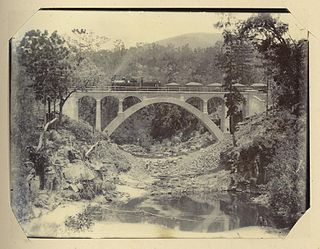
The Dawson Valley Branch Railway was a railway line in Central Queensland, Australia. It branched from the Central Western railway line at Kabra in the Rockhampton Region and went via Mount Morgan to Theodore in the Shire of Banana. It opened in a series of sections between 1898 and 1927, and featured a rack railway section, one of only 3 such systems in Australia.

<span class="mw-page-title-main">Central Western railway line</span> Railway line in Australia

The Central Western railway line is a railway line in Queensland, Australia. It was opened in a series of sections between 1867 and 1928. It commences at Rockhampton and extends west 863 kilometres (536 mi) to Winton.

<span class="mw-page-title-main">Moura railway line</span>

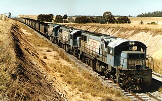
The Moura railway line is a railway in central Queensland, connecting several coal mines to the port of Gladstone. It connects the remnants of several lines that previously connected to Rockhampton, originally by a rack railway.

Harrami is a rural locality in the North Burnett Region, Queensland, Australia. In the 2021 census, Harrami had a population of 22 people.

Callide is a rural town and locality in the Shire of Banana, Queensland, Australia. In the 2016 census, the locality of Callide had a population of 86 people.

Valentine Plains is a rural locality in the Shire of Banana, Queensland, Australia. In the 2016 census, Valentine Plains had a population of 394 people.

<span class="mw-page-title-main">Lawgi Dawes</span> Suburb of Shire of Banana, Queensland, Australia

Lawgi Dawes is a rural locality in the Shire of Banana, Queensland, Australia. In the 2016 census, Lawgi Dawes had a population of 144 people. It contains the neighbourhood of Lawgi, a former town.

Dakenba is a rural locality in the Shire of Banana, Queensland, Australia. In the 2016 census, Dakenba had a population of 116 people.

<span class="mw-page-title-main">Coominglah, Queensland</span> Suburb of North Burnett Region, Queensland, Australia

Coominglah is a rural locality in the North Burnett Region, Queensland, Australia. The land use is grazing on native vegetation.

References

  1. "Queensland Two Mile series sheet 2m163" (Map). Queensland Government. 1939. Retrieved 27 December 2022.
  2. Moura Line Archived 14 March 2012 at the Wayback Machine
  3. "Towns of Rannes" (Map). Queensland Government. 1975. Archived from the original on 24 November 2022. Retrieved 29 December 2022.
  4. 1 2 3 4 5 6 7 8 9 10 "Railway stations and sidings - Queensland". Queensland Open Data. Queensland Government. 2 October 2020. Archived from the original on 5 October 2020. Retrieved 5 October 2020.
  5. "Queensland Two Mile series sheet 2m202" (Map). Queensland Government. 1948. Retrieved 29 December 2022.
  6. 1 2 "Queensland Two Mile series sheet 2m201" (Map). Queensland Government. 1947. Retrieved 29 December 2022.
  7. 1 2 3 4 5 6 7 "Queensland Two Mile series sheet 2m163" (Map). Queensland Government. 1950. Archived from the original on 26 December 2022. Retrieved 27 December 2022.

Works cited