New England Highway is an 883-kilometre (549 mi) long highway in Australia running from Yarraman, north of Toowoomba, Queensland, at its northern end to Hexham at Newcastle, New South Wales, at its southern end. It is part of Australia's National Highway system, and forms part of the inland route between Brisbane and Sydney.

Wallangarra is a rural town and locality in the Southern Downs Region, Queensland, Australia on the border with New South Wales. It is the third-most southerly town in Queensland, 258 kilometres (160 mi) south west of Brisbane. Wallangarra is on the Queensland side of the border and Jennings is on the New South Wales side.
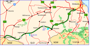
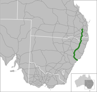
The Cunningham Highway is a 327-kilometre (203 mi) national highway located in south-eastern Queensland, Australia. The highway links the Darling Downs region with the urbanised outskirts of Ipswich via Cunninghams Gap.

The rail network in Queensland, Australia, was the first in the world to adopt 1,067 mm narrow gauge for a main line, and, in 2013, was claimed to the second largest narrow gauge network in the world, consists of:

The Amiens railway line was a branch railway in the Granite Belt region of Queensland, Australia, branching from the Southern Line at Cottonvale between Warwick and Stanthorpe. The Amiens line was the highest in southern Queensland, with the railway reaching an elevation of 946 metres above sea level at Pozieres.

The Goomburra railway line was a branch railway in the Southern Downs region of Queensland, Australia.

The Southern railway line serves the Darling Downs region of Queensland, Australia. The 197-kilometre (122 mi) long line branches from the Western line at Toowoomba, 161 kilometres (100 mi) west of Brisbane, and proceeds south through Warwick and Stanthorpe to the New South Wales/Queensland state border at Wallangarra.

Maryvale is a rural town and locality in the Southern Downs Region, Queensland, Australia. In the 2021 census, the locality of Maryvale had a population of 392 people.
Hendon is a rural town and locality in the Southern Downs Region, Queensland, Australia. In the 2021 census, the locality of Hendon had a population of 227 people.
The Mount Edwards railway line was a branch railway in the Scenic Rim region of South East Queensland, Australia. The lines serves a number of small towns in the Fassifern Valley. The first stage of the Mount Edwards line opened from Munbilla to Engelsburg on 17 April 1916, but the next stage to Mount Edwards was not completed until 7 October 1922. The line closed on 1 November 1960.

Queensland's railway construction commenced in 1864, with the turning of the first sod of the Main Line by Lady Diamantina Bowen, the wife of Queensland's first governor Sir George Bowen at Ipswich, Queensland, Australia. A narrow gauge of 3 ft 6 in was selected due to cost savings in providing a rail link to Toowoomba. Despite being built with bridges wide enough for standard gauge, and the fact that most other lines did not require heavy earthworks, the gauge remained the Queensland system norm.

The Main Line is a railway line in South East Queensland, Australia. It was opened in a series of sections between 1865 and 1867. It commences at Roma St Station in Brisbane and extends west 161 km to Toowoomba. It is the first narrow gauge main line constructed in the world. The section of the line from the end of Murphys Creek railway station to the Ruthven Street overbridge, Harlaxton is listed on the Queensland Heritage Register. The Murphys Creek Railway Complex, the Lockyer Creek Railway Bridge (Lockyer), the Lockyer Creek Railway Bridge and Swansons Rail Bridge are also heritage listed.

A Travelling Post Office (TPO) is a postal receiving, sorting and delivery service situated on a train, usually in a specially designated carriage that is part of a passenger train. In Queensland, Australia, the service was provided from 1877 to 1932.

Wallangarra railway station is a heritage-listed railway station at Woodlawn Street, Wallangarra, Southern Downs Region, Queensland, Australia. It was built in 1877 along the state border of Queensland and New South Wales It was added to the Queensland Heritage Register on 28 March 2003.

Quart Pot Creek Rail Bridge is a heritage-listed railway bridge at Quart Pot Creek, Stanthorpe, Southern Downs Region, Queensland, Australia. It was built in 1886. It is also known as the Red Bridge. It was added to the Queensland Heritage Register on 21 October 1992.
Tregony is a locality in the Southern Downs Region, Queensland, Australia. It is one of the major gateways to the Darling Downs from the Queensland coast. In the 2021 census, Tregony had a population of 36 people.

Clintonvale is a rural locality in the Southern Downs Region, Queensland, Australia. In the 2021 census, Clintonvale had a population of 72 people.
Sladevale is a rural locality in the Southern Downs Region, Queensland, Australia. In the 2021 census, Sladevale had a population of 433 people.
Womina is a rural locality in the Southern Downs Region, Queensland, Australia. In the 2021 census, Womina had a population of 207 people.
Morwincha is a rural locality in the Scenic Rim Region, Queensland, Australia. In the 2021 census, Morwincha had a population of 35 people.
"Triumph of Narrow Gauge: A History of Queensland Railways" by John Kerr 1990 & 1998 Boolarong Press, Brisbane