Clintonvale, Queensland

Last updated

Clintonvale
Queensland
Sunset and moonrise over Main Range National Park seen from Clintonvale, Queensland, 2021.jpg
Sunset and moonrise over Main Range National Park seen from Clintonvale, Queensland, 2021
Australia Queensland location map.svg
Red pog.svg
Clintonvale
Coordinates 28°05′45″S152°07′11″E / 28.0958°S 152.1197°E / -28.0958; 152.1197 (Clintonvale (centre of locality))
Population72 (2021 census) [1]
 • Density2.143/km2 (5.55/sq mi)
Postcode(s) 4370
Area33.6 km2 (13.0 sq mi)
Time zone AEST (UTC+10:00)
Location
LGA(s) Southern Downs Region
State electorate(s) Southern Downs
Federal division(s) Maranoa
Suburbs around Clintonvale:
Berat Goomburra Gladfield
Mount Marshall Clintonvale Freestone
Glengallan Sladevale Freestone

Clintonvale is a rural locality in the Southern Downs Region, Queensland, Australia. [2] In the 2021 census, Clintonvale had a population of 72 people. [1]

Contents

Geography

The Cunningham Highway passes through the locality from north-east (Gladfield) to south-west (Glengallan). [3]

Mount Stewart rises to 766 metres (2,513 ft) in the north of the locality ( 28°03′46″S152°06′58″E / 28.0627°S 152.1161°E / -28.0627; 152.1161 (Mount Stewart) ). [4] [5]

History

The locality was named after Henry E. Clinton, the roads superintendent who oversaw the building of the Warwick-Spicers Gap road in the 1860s. [2] [6]

Ross's Corner Provisional School opened at Cunningham Junction on 22 July 1907. On 1 January 1909, it became Ross's Corner State School. In 1915, it was renamed Clinton Vale State School, eventually Clintonvale State School. It closed in 2001. [7] [8] It was at 22 Clintonvale School Road ( 28°05′44″S152°07′51″E / 28.0956°S 152.1309°E / -28.0956; 152.1309 (Clintonvale State School (former)) ). [9] [10] [3] As at April 2021, the school building is still extant. [11] The school's website was archived. [12]

The Maryvale railway line opened from the Southern railway line to Maryvale on 30 September 1911, [13] with Clintonvale being served by the Clintonvale railway station ( 28°05′45″S152°07′45″E / 28.0959°S 152.1291°E / -28.0959; 152.1291 (Clintonvale railway station (former)) ). [10] Originally intended as a segment of a more direct (via recta) railway route from Brisbane to Sydney, the segment from Mount Edwards to Maryvale was never completed and the line remained a local branch line until it closed on 1 November 1960. [14] [15]

Demographics

In the 2016 census, Clintonvale had a population of 74 people. [16]

In the 2021 census, Clintonvale had a population of 72 people. [1]

Education

There are no schools in Clintonvale. The nearest government primary school in Freestone State School in neighbouring Freestone to the south. The nearest government secondary schools are Allora P-10 School (to Year 10) in Allora to the north-west and Warwick State High School (to Year 12) in Warwick to the south-west. [3]

Amenities

Lysaught Park is on the corner of the Cunningham Highway and Clintonvale School Road ( 28°05′42″S152°07′51″E / 28.0951°S 152.1308°E / -28.0951; 152.1308 (Lysaught Park) ). [17]

Related Research Articles

<span class="mw-page-title-main">Allora, Queensland</span> Town in Queensland, Australia

Allora is a rural town and locality in the Southern Downs Region, Queensland, Australia. In the 2021 census, the locality of Allora had a population of 1,205 people.

<span class="mw-page-title-main">Southern Downs Region</span> Local government area in Queensland, Australia

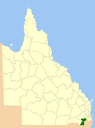
The Southern Downs Region is a local government area (LGA) in the Darling Downs region of Queensland, Australia. The region runs along the state's southern boundary with New South Wales and was created in 2008 from a merger of the Shire of Warwick and the Shire of Stanthorpe.

The Maryvale railway line was a branch railway in the Southern Downs region of Queensland, Australia.

<span class="mw-page-title-main">Karara, Queensland</span> Town in Queensland, Australia

Karara is a rural town and locality in the Southern Downs Region, Queensland, Australia. In the 2021 census, the locality of Karara had a population of 128 people.

<span class="mw-page-title-main">Maryvale, Queensland (Southern Downs Region)</span> Town in Queensland, Australia

Maryvale is a rural town and locality in the Southern Downs Region, Queensland, Australia. In the 2021 census, the locality of Maryvale had a population of 392 people.

Hendon is a rural town and locality in the Southern Downs Region, Queensland, Australia. In the 2021 census, the locality of Hendon had a population of 227 people.

The Mount Edwards railway line was a branch railway in the Scenic Rim region of South East Queensland, Australia. The lines serves a number of small towns in the Fassifern Valley. The first stage of the Mount Edwards line opened from Munbilla to Engelsburg on 17 April 1916, but the next stage to Mount Edwards was not completed until 7 October 1922. The line closed on 1 November 1960.

<span class="mw-page-title-main">Glengallan, Queensland</span> Suburb of Southern Downs Region, Queensland, Australia

Glengallan is a rural locality in the Southern Downs Region, Queensland, Australia. In the 2021 census, Glengallan had a population of 57 people.

<span class="mw-page-title-main">Swan Creek, Queensland</span> Suburb of Southern Downs Region, Queensland, Australia

Swan Creek is a rural locality in the Southern Downs Region, Queensland, Australia. In the 2021 census, Swan Creek had a population of 161 people.

<span class="mw-page-title-main">Yangan, Queensland</span> Town in Queensland, Australia

Yangan is a rural town and locality in the Southern Downs Region, Queensland, Australia. In the 2021 census, the locality of Yangan had a population of 404 people.

<span class="mw-page-title-main">Willowvale, Queensland</span> Suburb of Southern Downs Region, Queensland, Australia

Willowvale is a rural locality in the Southern Downs Region, Queensland, Australia. In the 2021 census, Willowvale had a population of 108 people.

<span class="mw-page-title-main">Mount Marshall, Queensland</span> Suburb of Southern Downs Region, Queensland, Australia

Mount Marshall is a rural locality in the Southern Downs Region, Queensland, Australia. In the 2021 census, Mount Marshall had a population of 229 people.

<span class="mw-page-title-main">Spring Creek, Queensland (Darling Downs)</span> Suburb of Toowoomba Region, Queensland, Australia

Spring Creek is a rural locality split between the Toowoomba Region and the Southern Downs Region, Queensland, Australia. In the 2021 census, Spring Creek had a population of 195 people.

<span class="mw-page-title-main">Freestone, Queensland</span> Town in Queensland, Australia

Freestone is a rural town and locality in the Southern Downs Region, Queensland, Australia. In the 2021 census, the locality of Freestone had a population of 208 people.

Berat is a rural locality in the Southern Downs Region, Queensland, Australia. In the 2021 census, Berat had a population of 129 people.

<span class="mw-page-title-main">Upper Freestone, Queensland</span> Suburb of Southern Downs Region, Queensland, Australia

Upper Freestone is a rural locality in the Southern Downs Region, Queensland, Australia. In the 2021 census, Upper Freestone had a population of 75 people.

Goomburra is a rural town and locality in the Southern Downs Region, Queensland, Australia. In the 2021 census, the locality of Goomburra had a population of 256 people.

<span class="mw-page-title-main">Thane, Queensland</span> Town in Queensland, Australia

Thane is a rural town and locality in the Southern Downs Region, Queensland, Australia. In the 2021 census, the locality of Thane had a population of 19 people.

Womina is a rural locality in the Southern Downs Region, Queensland, Australia. In the 2021 census, Womina had a population of 207 people.

<span class="mw-page-title-main">Mount Edwards, Queensland</span> Suburb of Scenic Rim Region, Queensland, Australia

Mount Edwards is a rural locality in the Scenic Rim Region, Queensland, Australia. In the 2021 census, Mount Edwards had a population of 60 people.

References

  1. 1 2 3 Australian Bureau of Statistics (28 June 2022). "Clintonvale (SAL)". 2021 Census QuickStats. Retrieved 28 February 2023. OOjs UI icon edit-ltr-progressive.svg
  2. 1 2 "Clintonvale – locality in Southern Downs Region (entry 45915)". Queensland Place Names. Queensland Government . Retrieved 7 March 2022.
  3. 1 2 3 "Queensland Globe". State of Queensland . Retrieved 28 April 2022.
  4. "Mountain peaks and capes - Queensland". Queensland Open Data. Queensland Government. 12 November 2020. Archived from the original on 25 November 2020. Retrieved 25 November 2020.
  5. "Mount Stewart – mountain in Southern Downs Region (entry 32374)". Queensland Place Names. Queensland Government . Retrieved 25 November 2020.
  6. "Spicers Gap Road Conservation Park (entry 601732)". Queensland Heritage Register . Queensland Heritage Council. Retrieved 1 August 2014.
  7. Queensland Family History Society (2010), Queensland schools past and present (Version 1.01 ed.), Queensland Family History Society, ISBN   978-1-921171-26-0
  8. "Queensland state school - centre closures" (PDF). Queensland Government . 20 August 2013. Archived (PDF) from the original on 20 March 2022. Retrieved 7 April 2022.
  9. "9341-41 Maryvale" (Map). Queensland Government. 1983. Archived from the original on 27 April 2022. Retrieved 28 April 2022.
  10. 1 2 "Parish of Glengallan" (Map). Queensland Government. 1947. Archived from the original on 24 March 2021. Retrieved 28 April 2022.
  11. Google (28 April 2022). "Clintonvale State School (former)" (Map). Google Maps . Google. Retrieved 28 April 2022.
  12. "Clintonvale State school". 28 November 2001. Archived from the original on 28 November 2001. Retrieved 28 April 2022.
  13. Kerr, John (1990). Triumph of narrow gauge : a history of Queensland Railways. Boolarong Publications. p. 225. ISBN   978-0-86439-102-5.
  14. Southern Downs Steam Railway (2008). "'Via recta' - The line that never was". Archived from the original on 12 September 2009. Retrieved 20 November 2008.
  15. Freestone Parents & Citizens Association (1988). "Railway". Archived from the original on 21 December 2008. Retrieved 20 November 2008.
  16. Australian Bureau of Statistics (27 June 2017). "Clintonvale (SSC)". 2016 Census QuickStats. Retrieved 20 October 2018. OOjs UI icon edit-ltr-progressive.svg
  17. "Land for public recreation - Queensland". Queensland Open Data. Queensland Government. 20 November 2020. Archived from the original on 22 November 2020. Retrieved 22 November 2020.

Further reading