Dalcouth, Queensland

Last updated

Map all coordinates using: OpenStreetMap  
Download coordinates as: KML
Dalcouth
Queensland
Australia Queensland location map.svg
Red pog.svg
Dalcouth
Coordinates 28°39′28″S151°59′25″E / 28.6577°S 151.9902°E / -28.6577; 151.9902 (Dalcouth (centre of locality)) Coordinates: 28°39′28″S151°59′25″E / 28.6577°S 151.9902°E / -28.6577; 151.9902 (Dalcouth (centre of locality))
Population165 (2016 census) [1]
 • Density8.21/km2 (21.26/sq mi)
Postcode(s) 4380
Area20.1 km2 (7.8 sq mi)
Time zone AEST (UTC+10:00)
Location
LGA(s) Southern Downs Region
State electorate(s) Southern Downs
Federal division(s) Maranoa
Suburbs around Dalcouth:
Stanthorpe Applethorpe Ruby Creek (NSW)
Diamondvale Dalcouth Ruby Creek (NSW)
Stanthorpe Kyoomba Sugarloaf

Dalcouth is a locality in the Southern Downs Region, Queensland, Australia. [2] It is on the border with New South Wales. [3] In the 2016 census, Dalcouth had a population of 165 people. [1]

Contents

Geography

The locality is loosely bounded by the Great Dividing Range to the north-east and east, which forms the border with New South Wales. [3]

Mount Koola is a mountain in the north-west of the locality ( 28°38′57″S151°58′35″E / 28.6491°S 151.9763°E / -28.6491; 151.9763 (Mount Koola) ) which rises to 948 metres (3,110 ft). [4] Koola is an Aboriginal wod meaning koala . [5]

History

Ten Mile Rock Provisional School opened on 27 July 1908. On 1 January 1909, it became Ten Mile Rock State School. In 1915, it was renamed Dalcouth State School. It closed in 1964. [6] It was at 182 Gentle Road ( 28°39′00″S151°59′16″E / 28.6499°S 151.9877°E / -28.6499; 151.9877 (Dalcouth State School (former)) ). [7] [3]

In the 2016 census, Dalcouth had a population of 165 people. [1]

During 2020 and 2021, the Queensland border was closed due to the COVID-19 pandemic. Some border crossing points had Queensland Police checkpoints to confirm eligibility to enter Queensland, while other border crossing points were closed. At Dalcouth, the border crossing on Amosfield Road to New South Wales ( 28°38′05″S151°59′54″E / 28.6346°S 151.9984°E / -28.6346; 151.9984 (Amosfield Road border crossing) ) was only open to local people with no through traffic permitted. [8]

Education

There are no schools in Dalcouth. The nearest government primary school is Stanthorpe State School and the nearest government secondary school is Stanthorpe State High School, both in neighbouring Stanthorpe to the west. [3]

Related Research Articles

Texas, Queensland Town in Queensland, Australia

Texas is a rural town and locality in the Goondiwindi Region, Queensland, Australia. It is on the border of Queensland and New South Wales. In the 2016 census, the locality of Texas had a population of 843 people.

Stanthorpe, Queensland Town in Queensland, Australia

Stanthorpe is a rural town and locality in the Southern Downs Region, Queensland, Australia. In the 2016 census, Stanthorpe had a population of 5,406 people.

Wallangarra, Queensland Town in Queensland, Australia

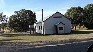
Wallangarra is a rural town and locality in the Southern Downs Region, Queensland, Australia. In the 2016 census the locality of Wallangarra had a population of 468 people.

Leyburn, Queensland Town in Queensland, Australia

Leyburn is a rural town in the Southern Downs Region and a locality split between the South Downs Region and the Toowoomba Region in Queensland, Australia. In the 2016 census, Leyburn had a population of 476 people.

Thulimbah, Queensland Town in Queensland, Australia

Thulimbah is a rural town and locality in the Southern Downs Region, Queensland, Australia. In the 2016 census the locality of Thulimbah had a population of 319 people. It borders New South Wales.

Applethorpe, Queensland Town in Queensland, Australia

Applethorpe is a rural town and locality in the Southern Downs Region, Queensland, Australia. In the 2016 census the locality of Applethorpe had a population of 511 people.

Amiens, Queensland Town in Queensland, Australia

Amiens is a rural locality in the Southern Downs Region, Queensland, Australia. In the 2016 census, Amiens had a population of 293 people.

Ballandean, Queensland Town in Queensland, Australia

Ballandean is a rural town and locality in the Southern Downs Region, Queensland, Australia. In the 2016 census, the locality of Ballandean had a population of 338 people.

Dalveen, Queensland Town in Queensland, Australia

Dalveen is a town and a locality in the Southern Downs Region, Queensland, Australia. It borders New South Wales. In the 2016 census, Dalveen had a population of 335 people.

Somme, Queensland Suburb of Southern Downs Region, Queensland, Australia

Somme is a rural locality in the Southern Downs Region, Queensland, Australia. In the 2016 census Somme had a population of 53 people.

The Summit, Queensland Town in Queensland, Australia

The Summit is a rural town and locality in the Southern Downs Region, Queensland, Australia. In the 2016 census, the locality of The Summit had a population of 409 people.

Eukey Suburb of Southern Downs Region, Queensland, Australia

Eukey is a rural locality in the Southern Downs Region, Queensland, Australia. It is on the border with New South Wales. In the 2016 census Eukey had a population of 134 people.

Mount Gipps, Queensland Suburb of Scenic Rim Region, Queensland, Australia

Mount Gipps is a rural locality in the Scenic Rim Region, Queensland, Australia. In the 2016 census, Mount Gipps had a population of 7 people.

Silver Spur is a rural town and locality in the Goondiwindi Region, Queensland, Australia. It is on the border of Queensland and New South Wales. In the 2016 census, Silver Spur had a population of 72 people.

Severnlea, Queensland Suburb of Southern Downs Region, Queensland, Australia

Severnlea is a locality in the Southern Downs Region, Queensland, Australia. In the 2016 census, Severnlea had a population of 350 people.

Glen Aplin is a rural locality in the Southern Downs Region, Queensland, Australia. In the 2016 census, Glen Aplin had a population of 503 people.

Cottonvale is a locality in the Southern Downs Region, Queensland, Australia. It borders New South Wales. In the 2016 census, Cottonvale had a population of 148 people. It contains the town of Cotton Vale.

Fletcher is a rural locality in the Southern Downs Region, Queensland, Australia. In the 2016 census, Fletcher had a population of 92 people.

Irvingdale is a locality split between the Toowoomba Region and the Western Downs Region, both in Queensland, Australia. In the 2016 census, Irvingdale had a population of 194 people.

Sugarloaf is a rural locality in the Southern Downs Region, Queensland, Australia. In the 2016 census, Sugarloaf had a population of 113 people.

References

  1. 1 2 3 Australian Bureau of Statistics (27 June 2017). "Dalcouth (SSC)". 2016 Census QuickStats. Retrieved 20 October 2018. OOjs UI icon edit-ltr-progressive.svg
  2. "Dalcouth – locality in Southern Downs Region (entry 49199)". Queensland Place Names. Queensland Government . Retrieved 8 November 2017.
  3. 1 2 3 4 "Queensland Globe". State of Queensland . Retrieved 24 January 2022.
  4. "Mount Koola – mountain in Southern Downs Region (entry 18434)". Queensland Place Names. Queensland Government . Retrieved 25 November 2020.
  5. "Mount Koola – mountain in Southern Downs Regional (entry 18434)". Queensland Place Names. Queensland Government . Retrieved 29 December 2020.
  6. Queensland Family History Society (2010), Queensland schools past and present (Version 1.01 ed.), Queensland Family History Society, ISBN   978-1-921171-26-0
  7. "Queensland Two Mile series sheet 2m7" (Map). Queensland Government. 1953. Retrieved 24 January 2022.
  8. "Road Status Update for Darling Downs as at 1:30am 7 April 2020". Department of Transport and Main Roads . Archived from the original on 6 April 2020. Retrieved 24 January 2022.{{cite web}}: CS1 maint: unfit URL (link)