Ellinthorp, Queensland

Last updated

Ellinthorp
Queensland
Australia Queensland location map.svg
Red pog.svg
Ellinthorp
Coordinates 28°02′53″S151°55′19″E / 28.0480°S 151.9219°E / -28.0480; 151.9219
Population30 (2021 census) [1]
 • Density8.8/km2 (23/sq mi)
Postcode(s) 4362
Area3.4 km2 (1.3 sq mi)
LGA(s) Southern Downs Region
State electorate(s) Southern Downs
Federal division(s) Maranoa
Localities around Ellinthorp:
Talgai Talgai Talgai
Talgai Ellinthorp Talgai
Talgai Talgai Talgai

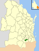
Ellinthorp is a rural town and a locality in the Southern Downs Region, Queensland, Australia. [2] [3] In the 2021 census, the locality of Ellinthorp had a population of 30 people. [1]

Contents

Geography

Dalrymple Creek forms the southern boundary of the locality and the South Western railway line forms the eastern boundary with the Ellinthorp railway station serving the town, which is immediately west of the station. [4]

Contrary to the Queensland Government's normal rules that no locality should be an "island" within another locality, [5] Ellinthorp is completely surrounded by the locality of Talgai. [4]

The town is no longer populated. [6]

History

The township was known as Talgai before it was renamed Ellinthorp on 19 March 1931. [2] The name Ellinthorp presumably comes from the Ellinthorp railway station, which was originally named Dalrymple after Dalrymple Creek, but which was renamed Ellinthorp on 28 January 1916 after the Tasmanian home of pastoralist brothers Charles George Henry Carr Clark and George John Edwin Clark of Talgai. [7] Although there are over 100 town lots in the town plan, many have not been developed while others are used for farming, [4] suggesting Ellinthorp was intended to be a more populous town. [4]

Demographics

In the 2016 census, the locality of had a population of 19 people. [8]

In the 2021 census, the locality of Ellinthorp had a population of 30 people. [1]

Related Research Articles

<span class="mw-page-title-main">Killarney, Queensland</span> Town in Queensland, Australia

Killarney is a rural town and locality in the Southern Downs Region, Queensland, Australia. It borders New South Wales. In the 2021 census, the locality of Killarney had a population of 918 people.

<span class="mw-page-title-main">Allora, Queensland</span> Town in Queensland, Australia

Allora is a rural town and locality in the Southern Downs Region, Queensland, Australia. In the 2021 census, the locality of Allora had a population of 1,205 people.

<span class="mw-page-title-main">Karara, Queensland</span> Town in Queensland, Australia

Karara is a rural town and locality in the Southern Downs Region, Queensland, Australia. In the 2021 census, the locality of Karara had a population of 128 people.

<span class="mw-page-title-main">Maryvale, Queensland (Southern Downs Region)</span> Town in Queensland, Australia

Maryvale is a rural town and locality in the Southern Downs Region, Queensland, Australia. In the 2021 census, the locality of Maryvale had a population of 392 people.

Cranley is a rural locality in the Toowoomba Region, Queensland, Australia. In the 2021 census, Cranley had a population of 2,281 people.

<span class="mw-page-title-main">Ballandean, Queensland</span> Town in Queensland, Australia

Ballandean is a rural town and locality in the Southern Downs Region, Queensland, Australia. The town has a number of nearby vineyards which attracted tourists to the area. In the 2021 census, the locality of Ballandean had a population of 316 people.

<span class="mw-page-title-main">Yangan, Queensland</span> Town in Queensland, Australia

Yangan is a rural town and locality in the Southern Downs Region, Queensland, Australia. In the 2021 census, the locality of Yangan had a population of 404 people.

<span class="mw-page-title-main">Munbilla, Queensland</span> Town in Queensland, Australia

Munbilla is a rural town and locality in the Scenic Rim Region, Queensland, Australia. In the 2021 census, the locality of Munbilla had a population of 93 people.

<span class="mw-page-title-main">Kents Lagoon, Queensland</span> Suburb of Scenic Rim Region, Queensland, Australia

Kents Lagoon is a rural locality in the Scenic Rim Region, Queensland, Australia. In the 2021 census, Kents Lagoon had a population of 60 people.

<span class="mw-page-title-main">Brookstead, Queensland</span> Town in Queensland, Australia

Brookstead is a rural town and locality in the Toowoomba Region, Queensland, Australia. In the 2021 census, the locality of Brookstead had a population of 182 people.

Goomburra is a rural town and locality in the Southern Downs Region, Queensland, Australia. In the 2021 census, the locality of Goomburra had a population of 256 people.

<span class="mw-page-title-main">Thane, Queensland</span> Town in Queensland, Australia

Thane is a rural town and locality in the Southern Downs Region, Queensland, Australia. In the 2016 census, Thane had a population of 27 people.

Talgai is a rural locality in the Southern Downs Region, Queensland, Australia. In the 2021 census, Talgai had a population of 106 people.

<span class="mw-page-title-main">Grasstree Beach, Queensland</span> Suburb of Mackay Region, Queensland, Australia

Grasstree Beach is a coastal locality in the Mackay Region, Queensland, Australia. It contains two towns, Grasstree in the centre of the locality and Zelma on the coast. In the 2021 census, Grasstree Beach had a population of 717 people.

Womina is a rural locality in the Southern Downs Region, Queensland, Australia. In the 2021 census, Womina had a population of 207 people.

Fletcher is a rural locality in the Southern Downs Region, Queensland, Australia. In the 2021 census, Fletcher had a population of 128 people.

<span class="mw-page-title-main">Glen Niven, Queensland</span> Suburb of Southern Downs Region, Queensland, Australia

Glen Niven is a rural locality in the Southern Downs Region, Queensland, Australia. It is within the Granite Belt on the Darling Downs and adjacent to the border with New South Wales. In the 2021 census, Glen Niven had a population of 99 people.

<span class="mw-page-title-main">Victoria Hill, Queensland</span> Suburb of Southern Downs Region, Queensland, Australia

Victoria Hill is a rural locality spit between the Southern Downs Region and the Toowoomba Region, both in Queensland, Australia. In the 2021 census, Victoria Hill had a population of 48 people.

Blaxland is a rural locality in the Western Downs Region, Queensland, Australia. In the 2021 census, Blaxland had a population of 58 people.

Old Talgai is a rural locality in the Southern Downs Region, Queensland, Australia. In the 2021 census, Old Talgai had a population of 28 people.

References

  1. 1 2 3 Australian Bureau of Statistics (28 June 2022). "Ellinthorp (SAL)". 2021 Census QuickStats. Retrieved 28 February 2023. OOjs UI icon edit-ltr-progressive.svg
  2. 1 2 "Ellinthorp – town in Southern Downs Region (entry 46014)". Queensland Place Names. Queensland Government . Retrieved 24 November 2018.
  3. "Ellinthorp – locality in Southern Downs Region (entry 45924)". Queensland Place Names. Queensland Government . Retrieved 24 November 2018.
  4. 1 2 3 4 "Queensland Globe". State of Queensland . Retrieved 23 November 2018.
  5. "How places are named: Defining boundaries and extent: Locality boundaries". Queensland Government. Archived from the original on 14 August 2019. Retrieved 24 November 2018.
  6. "Ellinthorp – town in Southern Downs Region (entry 46014)". Queensland Place Names. Queensland Government . Retrieved 31 December 2017.
  7. "Ellinthorp – railway station in Southern Downs Region (entry 11542)". Queensland Place Names. Queensland Government . Retrieved 24 November 2018.
  8. Australian Bureau of Statistics (27 June 2017). "Ellinthorp (SSC)". 2016 Census QuickStats. Retrieved 20 October 2018. OOjs UI icon edit-ltr-progressive.svg