
Roadvale is a rural locality in the Scenic Rim Region, Queensland, Australia. In the 2021 census, the locality of Roadvale had a population of 303 people.

Allora is a rural town and locality in the Southern Downs Region, Queensland, Australia. In the 2021 census, the locality of Allora had a population of 1,205.
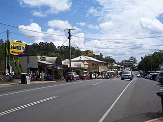
Eumundi is a rural town and locality in the Sunshine Coast Region, Queensland, Australia. Eumundi is very popular on the coast for its bi-weekly farmers' markets.
Montville is a rural town and locality in the Sunshine Coast Region, Queensland, Australia. In the 2021 census, the locality of Montville had a population of 1,092 people.

Grandchester is a rural town and locality in the City of Ipswich, Queensland, Australia. In the 2021 census, the locality of Grandchester had a population of 467 people.

Leyburn is a rural town in the Southern Downs Region and a locality split between the South Downs Region and the Toowoomba Region in Queensland, Australia. In the 2021 census, the locality of Leyburn had a population of 566 people.

Mount Mee is a rural town and locality in the City of Moreton Bay, Queensland, Australia. In the 2021 census, the locality of Mount Mee had a population of 519 people.

Maryvale is a rural town and locality in the Southern Downs Region, Queensland, Australia. In the 2021 census, the locality of Maryvale had a population of 392 people.

Glengallan is a rural locality in the Southern Downs Region, Queensland, Australia. In the 2021 census, Glengallan had a population of 57 people.
Swan Creek is a rural locality in the Southern Downs Region, Queensland, Australia. In the 2021 census, Swan Creek had a population of 161 people.

Yangan is a rural town and locality in the Southern Downs Region, Queensland, Australia. In the 2021 census, the locality of Yangan had a population of 404 people.

Gowrie Little Plain is a rural locality in the Toowoomba Region, Queensland, Australia. In the 2021 census, Gowrie Little Plain had a population of 79 people.

The Summit is a rural town and locality in the Southern Downs Region, Queensland, Australia. In the 2021 census, the locality of The Summit had a population of 436 people.

Mount Marshall is a rural locality in the Southern Downs Region, Queensland, Australia. In the 2021 census, Mount Marshall had a population of 229 people.

Spring Creek is a rural locality split between the Toowoomba Region and the Southern Downs Region, Queensland, Australia. In the 2021 census, Spring Creek had a population of 195 people.
Berat is a rural locality in the Southern Downs Region, Queensland, Australia. In the 2021 census, Berat had a population of 129 people.
Clintonvale is a rural locality in the Southern Downs Region, Queensland, Australia. In the 2021 census, Clintonvale had a population of 72 people.

Thane is a rural town and locality in the Southern Downs Region, Queensland, Australia. In the 2021 census, the locality of Thane had a population of 19 people.

Gheerulla is a rural locality in the Sunshine Coast Region, Queensland, Australia. In the 2021 census, Gheerulla had a population of 291 people.
Forest Springs is a rural locality in the Southern Downs Region, Queensland, Australia. In the 2021 census, Forest Springs had a population of 104 people.


