
Stanthorpe is a rural town and locality in the Southern Downs Region, Queensland, Australia. In the 2021 census, the locality of Stanthorpe had a population of 5,286 people.

Wallangarra is a rural town and locality in the Southern Downs Region, Queensland, Australia on the border with New South Wales. It is the third-most southerly town in Queensland, 258 kilometres (160 mi) south west of Brisbane. Wallangarra is on the Queensland side of the border and Jennings is on the New South Wales side.

Applethorpe is a rural town and locality in the Southern Downs Region, Queensland, Australia. It is on Queensland's border with New South Wales. It is well known for the production of apples. It often records the lowest temperatures in Queensland.

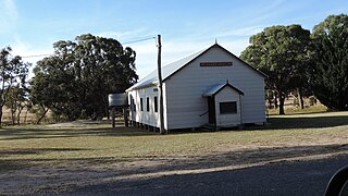
Amiens is a rural locality in the Southern Downs Region, Queensland, Australia. In the 2021 census, Amiens had a population of 343 people.

Dalveen is a town and a locality in the Southern Downs Region, Queensland, Australia. It borders New South Wales. In the 2021 census, the locality of Dalveen had a population of 369 people.

Groomsville is a rural locality in the Toowoomba Region on the Darling Downs, Queensland, Australia. In the 2021 census, Groomsville had a population of 132 people.

The Summit is a rural town and locality in the Southern Downs Region, Queensland, Australia. In the 2021 census, the locality of The Summit had a population of 436 people.
Eukey is a rural locality in the Southern Downs Region, Queensland, Australia. It is on the border with New South Wales. In the 2021 census, Eukey had a population of 140 people.
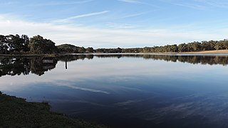
Storm King Dam is a reservoir created by the dam of the same name in the locality of Storm King in the Southern Downs Region, Queensland, Australia. It provides water for the town of Stanthorpe.
Glen Aplin is a rural locality in the Southern Downs Region, Queensland, Australia. In the 2021 census, Glen Aplin had a population of 566 people.
Glenlyon is a rural locality in the Southern Downs Region, Queensland, Australia. In the 2021 census, Glenlyon had a population of 32 people.
Fletcher is a rural locality in the Southern Downs Region, Queensland, Australia. In the 2021 census, Fletcher had a population of 128 people.
Mount Tully is a rural locality in the Southern Downs Region, Queensland, Australia. In the 2021 census, Mount Tully had a population of 117 people.
Glen Niven is a rural locality in the Southern Downs Region, Queensland, Australia. It is within the Granite Belt on the Darling Downs and adjacent to the border with New South Wales. In the 2021 census, Glen Niven had a population of 99 people.

Kyoomba is a rural locality in the Southern Downs Region, Queensland, Australia. In the 2021 census, Kyoomba had a population of 83 people.

Leslie Dam is a locality in the Southern Downs Region, Queensland, Australia. In the 2021 census, Leslie Dam had a population of 118 people.
Lake Monduran is a rural locality in the Bundaberg Region, Queensland, Australia. In the 2021 census, Lake Monduran had "no people or a very low population".

Silverwood is a rural locality in the Southern Downs Region, Queensland, Australia. In the 2021 census, Silverwood had a population of 58 people.
Palgrave is a rural locality in the Southern Downs Region, Queensland, Australia. In the 2021 census, Palgrave had a population of 35 people.
Passchendaele is a rural locality in the Southern Downs Region, Queensland, Australia. In the 2021 census, Passchendaele had a population of 42 people.

