Amiens, Queensland

Last updated

Amiens
Queensland
Pikedale soldier settlement information board, Amiens, 2015.JPG
Information board about the Pikedale soldier settlements, Amiens, 2015
Australia Queensland location map.svg
Red pog.svg
Amiens
Coordinates 28°35′55″S151°48′59″E / 28.5986°S 151.8163°E / -28.5986; 151.8163 (Amiens (centre of locality))
Population343 (2021 census) [1]
 • Density6.609/km2 (17.12/sq mi)
Postcode(s) 4380
Area51.9 km2 (20.0 sq mi)
Time zone AEST (UTC+10:00)
Location
LGA(s) Southern Downs Region
State electorate(s) Southern Downs
Federal division(s) Maranoa
Suburbs around Amiens:
Goldfields Passchendaele Bapaume
Pikedale Amiens Cannon Creek
Pikedale Greenlands Broadwater

Amiens is a rural locality in the Southern Downs Region, Queensland, Australia. [2] In the 2021 census, Amiens had a population of 343 people. [1]

Contents

History

Amiens settlement, 1920 StateLibQld 2 174619 Amiens settlement, 1920.jpg
Amiens settlement, 1920

Following World War I, Amiens was one of the Pikedale soldier settlements established in the Granite Belt area of the Darling Downs. [3]

The name Amiens refers to the World War I battlefield in northern France, of special importance to the Australian Imperial Force in March–April 1918. The name was suggested by surveyor George Grant in 1920. [2]

Construction of the Amiens railway line commenced in 1919 and the line was opened on 7 June 1920 with the locality being served by the now-dismantled Amiens railway station ( 28°35′12″S151°48′22″E / 28.5866°S 151.8062°E / -28.5866; 151.8062 (Amiens railway station (former)) ). [4] [5] Edward, Prince of Wales travelled the length of the Amiens branch in a royal train to officially open the line on 26 July 1920. [6]

Methodist Church in Amiens, circa 1920 Methodist Church, Amiens, circa 1920.jpg
Methodist Church in Amiens, circa 1920

On Saturday 15 October 1921, a Methodist church was officially opened in Amiens by Reverend Edwin George Walker, of Stanthorpe. [7] It had been relocated from Tannymorel (where it had been opened in 1902). [8] [9] In 1945, it was relocated to Severnlea, where it is now operates as the Severnlea Uniting Church. [10]

Although the intention of the soldier settlement farms in the district was fruit growing, the fruit trees required a number of years before they would bear fruit and the government loans on the farms required immediate interest payments. Many soldier settlers turned to vegetable growing, both for their own use and to enable them to sell for a short-term income. [11]

Amiens State School, 1922 StateLibQld 1 106224 Students and teachers gathered outside Amiens State School, 1922.jpg
Amiens State School, 1922

Pikedale Soldier's Settlement State School opened on 10 March 1919. In 1920 it was renamed Amiens State School. [12] [13]

On Sunday 1 July 1923, St Denys' Anglican Church was officially opened by Canon David Garland. [14] [15] [16] It was named after St Denys, a patron saint of France. [10]

On Saturday 26 June 1926, the Amiens Memorial School of Arts and Hall was officially opened by Major Edward Costello, the Member of the Queensland Legislative Assembly for Carnarvon. [17] It was used for the annual agricultural show as well as social events such as dances. It was located in Memorial Lane, but was relocated in the 1980s to Storm King Dam to be used as a recreation centre in the youth camp. [10] [18]

St Patrick's Catholic Church was established in 1964, having been relocated from Sugarloaf. [19]

The railway line closed on 28 February 1974. [4] Fruit and vegetables are carried by road to the markets.

Demographics

In the 2016 census, Amiens had a population of 293 people. [20]

In the 2021 census, Amiens had a population of 343 people. [1]

Heritage listings

Amiens has a number of heritage-listed sites, including:

Economy

Apple trees under netting to protect them from hail, Amiens, 2015 Apple trees under netting to protect them from hail, Amiens, 2015.JPG
Apple trees under netting to protect them from hail, Amiens, 2015

Amiens is a fruit and vegetable growing district. As the Granite Belt suffers from regular hail, many orchards are protected by hail nets. Traditionally hail nets were intended to prevent the hail from entering the orchard; however, the heavy hail would pool in the nets and break through onto the orchard below. Modern hail nets are designed to have gullies between the rows of the trees which allow the hail to fall into the orchards but avoiding the fruit on the trees. [22]

Education

Amiens State School, 2023 Amiens State School, 2023 03.jpg
Amiens State School, 2023

Amiens State School is a government primary (Prep-6) school for boys and girls at 1337 Amiens Road ( 28°35′40″S151°48′45″E / 28.5945°S 151.8126°E / -28.5945; 151.8126 (Amiens State School) ). [23] [24] In 2018, the school had an enrolment of 39 students with 3 teachers and 6 non-teaching staff (3 full-time equivalent). [25]

There is no secondary school in Amiens. The nearest government secondary school is Stanthorpe State High School in Stanthorpe to the south-east. [26]

Amenities

St Denys Anglican Church, Amiens, 2015 St Denys Anglican Church, Amiens, 2015.JPG
St Denys Anglican Church, Amiens, 2015

St Denys Anglican Church is at 17 Trevethan Lane ( 28°35′26″S151°48′31″E / 28.5906°S 151.8087°E / -28.5906; 151.8087 (St Denys Anglican Church) ). It is part of the Stanthorpe Parish within the Anglican Diocese of Brisbane. [27]

St Patrick's Catholic Church is at 10 Goldfields Road ( 28°35′10″S151°48′23″E / 28.5860°S 151.8063°E / -28.5860; 151.8063 (St Patrick's Catholic Church) ). [19]

Attractions

The Amiens Legacy Centre is at 17 Goldfield Road ( 28°35′11″S151°48′22″E / 28.5865°S 151.8060°E / -28.5865; 151.8060 (Amiens Legacy Centre) ). It is operated by the Amiens History Association. Tours are available. [28]

The Robert Channon Winery hosts musical events in their Swigmore Hall. [29]

Related Research Articles

<span class="mw-page-title-main">Stanthorpe, Queensland</span> Town in Queensland, Australia

Stanthorpe is a rural town and locality in the Southern Downs Region, Queensland, Australia. In the 2021 census, the locality of Stanthorpe had a population of 5,286 people.

<span class="mw-page-title-main">Wallangarra, Queensland</span> Town in Queensland, Australia

Wallangarra is a rural town and locality in the Southern Downs Region, Queensland, Australia on the border with New South Wales. It is the third-most southerly town in Queensland, 258 kilometres (160 mi) south west of Brisbane. Wallangarra is on the Queensland side of the border and Jennings is on the New South Wales side.

<span class="mw-page-title-main">Granite Belt</span> Region in Queensland, Australia

The Granite Belt is an area of the Great Dividing Range in the Darling Downs region of Queensland and the New England region of New South Wales, Australia. The Granite Belt is centred on the town of Stanthorpe. The cool, high country of the granite belt is located on Queensland's southern border. It is the northernmost part of the New England Tablelands.

<span class="mw-page-title-main">Wondai</span> Town in Queensland, Australia

Wondai is a rural town and locality in the South Burnett Region, Queensland, Australia. In the 2021 census, Wondai had a population of 1,975 people.

<span class="mw-page-title-main">Leyburn, Queensland</span> Town in Queensland, Australia

Leyburn is a rural town in the Southern Downs Region and a locality split between the South Downs Region and the Toowoomba Region in Queensland, Australia. In the 2016 census, Leyburn had a population of 476 people.

<span class="mw-page-title-main">Applethorpe, Queensland</span> Town in Queensland, Australia

Applethorpe is a rural town and locality in the Southern Downs Region, Queensland, Australia. It is on Queensland's border with New South Wales. It is well known for the production of apples. It often records the lowest temperatures in Queensland.

<span class="mw-page-title-main">Ballandean, Queensland</span> Town in Queensland, Australia

Ballandean is a rural town and locality in the Southern Downs Region, Queensland, Australia. In the 2021 census, the locality of Ballandean had a population of 316 people.

<span class="mw-page-title-main">Dalveen, Queensland</span> Town in Queensland, Australia

Dalveen is a town and a locality in the Southern Downs Region, Queensland, Australia. It borders New South Wales. In the 2016 census, Dalveen had a population of 335 people.

<span class="mw-page-title-main">Mount Tyson, Queensland</span> Town in Queensland, Australia

Mount Tyson is a rural town and locality in the Toowoomba Region, Queensland, Australia. In the 2016 census, the locality of Mount Tyson had a population of 285 people.

<span class="mw-page-title-main">St Denys Anglican Church</span> Historic site in Queensland, Australia

St Denys Anglican Church is a heritage-listed church at 17 Trevethan Lane, Amiens, Southern Downs Region, Queensland, Australia. It was built from 1923 to 1923. It is also known as Church of St Denys. It was added to the Queensland Heritage Register on 3 August 2005.

<span class="mw-page-title-main">The Summit, Queensland</span> Town in Queensland, Australia

The Summit is a rural town and locality in the Southern Downs Region, Queensland, Australia. In the 2016 census, the locality of The Summit had a population of 409 people.

<span class="mw-page-title-main">Storm King Dam</span> Reservoir in South-East of Stanthorpe, Queensland

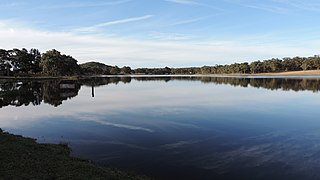
Storm King Dam is a reservoir created by the dam of the same name in the locality of Storm King in the Southern Downs Region, Queensland, Australia. It provides water for the town of Stanthorpe.

Limevale is a rural locality in the Goondiwindi Region, Queensland, Australia. In the 2021 census, Limevale had a population of 49 people.

<span class="mw-page-title-main">Oman Ama, Queensland</span> Suburb of Goondiwindi Region, Queensland, Australia

Oman Ama is a rural locality in the Goondiwindi Region, Queensland, Australia. In the 2021 census, Oman Ama had a population of 31 people.

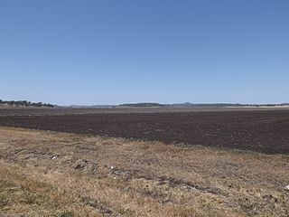
Pikedale is a rural locality in the Southern Downs Region, Queensland, Australia. It is one of the areas used for soldier settlements following service in World War I.

Glen Aplin is a rural locality in the Southern Downs Region, Queensland, Australia. In the 2021 census, Glen Aplin had a population of 566 people.

Pozieres is a rural locality in the Southern Downs Region, Queensland, Australia. In the 2021 census, Pozieres had a population of 208 people.

Kooroongarra is a rural town and locality in the Toowoomba Region, Queensland, Australia. In the 2016 census, the locality of Kooroongarra had a population of 58 people.

Passchendaele is a rural locality in the Southern Downs Region, Queensland, Australia. In the 2021 census, Passchendaele had a population of 42 people.

Sugarloaf is a rural locality in the Southern Downs Region, Queensland, Australia. In the 2021 census, Sugarloaf had a population of 162 people.

References

  1. 1 2 3 Australian Bureau of Statistics (28 June 2022). "Amiens (SAL)". 2021 Census QuickStats. Retrieved 28 February 2023. OOjs UI icon edit-ltr-progressive.svg
  2. 1 2 "Amiens – locality in Southern Downs Region (entry 50091)". Queensland Place Names. Queensland Government . Retrieved 29 December 2020.
  3. Randall, Brian (3 November 2014). "Pikedale soldier settlements". State Library of Queensland. Archived from the original on 26 July 2017. Retrieved 2 June 2015.
  4. 1 2 Southern Downs Steam Railway (2008). "Historical information: (Warwick) – Cottonvale – Amiens". Archived from the original on 6 January 2009. Retrieved 18 November 2008.
  5. "Railway stations and sidings - Queensland". Queensland Open Data. Queensland Government. 2 October 2020. Archived from the original on 5 October 2020. Retrieved 5 October 2020.
  6. QR Limited. "QR History – Royal goes by train". Archived from the original on 19 July 2008. Retrieved 18 November 2008.
  7. "NEW CHURCH". Daily Mail . No. 6044. Queensland, Australia. 17 October 1921. p. 6. Archived from the original on 26 January 2022. Retrieved 26 January 2022 via National Library of Australia.
  8. "METHODISM". Warwick Daily News . No. 5109. Queensland, Australia. 30 November 1935. p. 8. Archived from the original on 11 September 2021. Retrieved 10 September 2021 via National Library of Australia.
  9. "Church at Tannymorel". Warwick Examiner And Times . Vol. 36, no. 4680. Queensland, Australia. 18 October 1902. p. 2. Archived from the original on 16 March 2021. Retrieved 6 July 2020 via National Library of Australia.
  10. 1 2 3 "Social". Amiens History Association. Archived from the original on 25 January 2022. Retrieved 25 January 2022.
  11. "Amiens, Thulimba, Applethorpe district". Queensland Places. Centre for the Government of Queensland, University of Queensland. Archived from the original on 11 June 2015. Retrieved 2 June 2015.
  12. Queensland Family History Society (2010), Queensland schools past and present (Version 1.01 ed.), Queensland Family History Society, ISBN   978-1-921171-26-0
  13. "Opening and closing dates of Queensland Schools". Queensland Government . Retrieved 18 April 2019.
  14. "ST. DENY'S CHURCH". The Brisbane Courier . No. 20, 418. Queensland, Australia. 2 July 1923. p. 3. Archived from the original on 26 January 2022. Retrieved 26 January 2022 via National Library of Australia.
  15. "St Denys' Anglican Church". Churches Australia. Archived from the original on 26 January 2022. Retrieved 26 January 2022.
  16. Blake, Thom. "St Denys' Anglican Church". Queensland religious places database. Archived from the original on 26 January 2022. Retrieved 26 January 2022.
  17. "AMIENS". The Brisbane Courier . No. 21, 356. Queensland, Australia. 7 July 1926. p. 20. Archived from the original on 26 January 2022. Retrieved 27 January 2022 via National Library of Australia.
  18. "Amiens Memorial Hall, ca. 1955". State Library of Queensland . Archived from the original on 26 January 2022. Retrieved 26 January 2022.
  19. 1 2 Blake, Thom. "St Patrick's Catholic Church". Queensland religious places database. Archived from the original on 26 January 2022. Retrieved 26 January 2022.
  20. Australian Bureau of Statistics (27 June 2017). "Amiens (SSC)". 2016 Census QuickStats. Retrieved 20 October 2018. OOjs UI icon edit-ltr-progressive.svg
  21. "St Denys Anglican Church (entry 602530)". Queensland Heritage Register . Queensland Heritage Council. Retrieved 13 July 2013.
  22. "Hail lashes Stanthorpe region". Warwick Daily News. 28 October 2011. Archived from the original on 2 February 2017. Retrieved 2 June 2015.
  23. "State and non-state school details". Queensland Government. 9 July 2018. Archived from the original on 21 November 2018. Retrieved 21 November 2018.
  24. "Amiens State School". Archived from the original on 4 April 2021. Retrieved 26 March 2021.
  25. "ACARA School Profile 2018". Australian Curriculum, Assessment and Reporting Authority. Archived from the original on 27 August 2020. Retrieved 28 January 2020.
  26. "Queensland Globe". State of Queensland . Retrieved 26 March 2021.
  27. "Contact Us | Stanthorpe Anglican Parish | Queensland". Stanthorpe Anglican. Archived from the original on 16 April 2021. Retrieved 25 January 2022.
  28. "Amiens Legacy Centre". Amiens History Association. Archived from the original on 25 January 2022. Retrieved 26 January 2022.
  29. "Our Story". Robert Channon Wines. Archived from the original on 26 October 2022. Retrieved 16 February 2023.