Lyra, Queensland

Last updated

Map all coordinates using: OpenStreetMap
Lyra
Queensland
Rural views (cows and wallabies) from Lyra Cafe, 2015.JPG
Rural views (cows and wallabies), Lyra, 2015
Australia Queensland location map.svg
Red pog.svg
Lyra
Coordinates 28°49′54″S151°51′54″E / 28.8316°S 151.8650°E / -28.8316; 151.8650 (Lyra (centre of locality))
Population53 (2016 census) [1]
 • Density4.14/km2 (10.72/sq mi)
Postcode(s) 4382
Area12.8 km2 (4.9 sq mi)
Time zone AEST (UTC+10:00)
Location
LGA(s) Southern Downs Region
State electorate(s) Southern Downs
Federal division(s) Maranoa
Suburbs around Lyra:
Ballandean Ballandean Ballandean
Ballandean Lyra Girraween
Ballandean Wyberba Wyberba

Lyra is a rural locality in the Southern Downs Region, Queensland, Australia. [2] In the 2016 census, Lyra had a population of 53 people. [1]

Contents

Geography

The western and central part of the locality is relatively flat but the eastern part of the locality consists of foothills of the Great Dividing Range. [3]

Accommodation Creek flows down from the range from the south-east (Wyberba) and exits to the north-west (Ballandean). Bald Rock Creek flows down from the range from the north-east (Ballandean) and becomes a tributary of Accommodation Creek at 28°49′40″S151°51′46″E / 28.8277°S 151.8627°E / -28.8277; 151.8627 (Bald Rock Creek (mouth)) . [4] Doctors Creek flows down from the range from the west (Girraween) and becomes a tributary of Bald Rock Creek at 28°49′29″S151°52′49″E / 28.8247°S 151.8802°E / -28.8247; 151.8802 (Doctors Creek (mouth)) . [5]

The New England Highway enters the locality from the north-west (Ballandean) and exits to the south (Wyberba). The Southern railway line runs parallel immediately to the east of the highway; there is no longer a railway station within Lyra. [5]

The land use is a mixture of horticulture and grazing on native vegetation. [3] There are a number of vineyards in Lyra, including those of Sirromet Wines at 115 Anderson Road ( 28°49′47″S151°52′07″E / 28.8297°S 151.8685°E / -28.8297; 151.8685 (Sirromet Wines) ). [6] There are no protected areas within Lyra, but it borders Girraween National Park to the east. [3]

History

The extension of the Southern railway line from Stanthorpe to Wallangarra was completed on 14 February 1887 with the district being served by Lyra railway station ( 28°49′47″S151°51′18″E / 28.8297°S 151.8550°E / -28.8297; 151.8550 (Lyra railway station) ), which was named by the Queensland Railway Department after the constellation Lyra. [7] [8] The locality takes its name from the railway station. [2]

Lyra State School opened on 7 November 1929 with an enrolment of 10 students under head teacher Kathleen May O'Donohue. The school site was donated by Evan Hindmarsh. The school building was relocated from the former Applevale State School while the school furniture came from the former Somme State School. The school closed on 19 June 1966, with the students being transferred to Ballandean State School. [9] [10]

In the 2016 census, Lyra had a population of 53 people. [1]

Related Research Articles

<span class="mw-page-title-main">Stanthorpe, Queensland</span> Town in Queensland, Australia

Stanthorpe is a rural town and locality in the Southern Downs Region, Queensland, Australia. In the 2016 census, Stanthorpe had a population of 5,406 people.

<span class="mw-page-title-main">Wallangarra, Queensland</span> Town in Queensland, Australia

Wallangarra is a rural town and locality in the Southern Downs Region, Queensland, Australia on the border with New South Wales. In the 2016 census, the locality of Wallangarra had a population of 468 people.

<span class="mw-page-title-main">Granite Belt</span> Region in Queensland, Australia

The Granite Belt is an area of the Great Dividing Range in the Darling Downs region of Queensland and the New England region of New South Wales, Australia. The Granite Belt is centred on the town of Stanthorpe. The cool, high country of the granite belt is located on Queensland's southern border. It is the northernmost part of the New England Tablelands.

<span class="mw-page-title-main">Shire of Stanthorpe</span> Local government area in Queensland, Australia

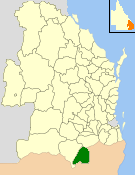
The Shire of Stanthorpe was a local government area of Queensland, Australia on the Queensland-New South Wales border. It was on the Great Dividing Range and was part of the Granite Belt. Its main industries included fruit and vegetable growing, wineries and tourism, and sheep and cattle grazing.

<span class="mw-page-title-main">Bell, Queensland</span> Town in Queensland, Australia

Bell is a rural town and locality in the Western Downs Region, Queensland, Australia. In the 2016 census, the locality of Bell had a population of 502 people.

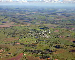
Wyreema is a rural town and locality in the Toowoomba Region, Queensland, Australia. In the 2016 census, the locality of Wyreema had a population of 1,834 people.

<span class="mw-page-title-main">Thulimbah, Queensland</span> Town in Queensland, Australia

Thulimbah is a rural town and locality in the Southern Downs Region, Queensland, Australia. In the 2016 census the locality of Thulimbah had a population of 319 people. It borders New South Wales.

<span class="mw-page-title-main">Karara, Queensland</span> Town in Queensland, Australia

Karara is a rural town and locality in the Southern Downs Region, Queensland, Australia. In the 2016 census, the locality of Karara had a population of 123 people.

<span class="mw-page-title-main">Ballandean, Queensland</span> Town in Queensland, Australia

Ballandean is a rural town and locality in the Southern Downs Region, Queensland, Australia. In the 2016 census, the locality of Ballandean had a population of 338 people.

<span class="mw-page-title-main">Allan, Queensland</span> Suburb of Southern Downs Region, Queensland, Australia

Allan is a rural locality in the Southern Downs Region, Queensland, Australia. It was formerly known as Sandy Creek. In the 2016 census, Allan had a population of 87 people.

<span class="mw-page-title-main">Eukey</span> Suburb of Southern Downs Region, Queensland, Australia

Eukey is a rural locality in the Southern Downs Region, Queensland, Australia. It is on the border with New South Wales. In the 2016 census Eukey had a population of 134 people.

Greymare is a rural locality in the Southern Downs Region, Queensland, Australia. In the 2016 census Greymare had a population of 64 people.

<span class="mw-page-title-main">Thane, Queensland</span> Town in Queensland, Australia

Thane is a rural town and locality in the Southern Downs Region, Queensland, Australia. In the 2016 census, Thane had a population of 27 people.

Wyberba is a rural locality in the Southern Downs Region, Queensland, Australia. In the 2016 census Wyberba had a population of 71 people.

Fletcher is a rural locality in the Southern Downs Region, Queensland, Australia. In the 2016 census, Fletcher had a population of 92 people.

<span class="mw-page-title-main">Fleurbaix, Queensland</span> Suburb of Southern Downs Region, Queensland, Australia

Fleurbaix is a locality in the Southern Downs Region, Queensland, Australia. In the 2021 census, Fleurbaix had a population of 56 people.

<span class="mw-page-title-main">Girraween, Queensland</span> Suburb of Southern Downs Region, Queensland, Australia

Girraween is an undeveloped locality in the Southern Downs Region, Queensland, Australia. It is in the Granite Belt and on the border with New South Wales. In the 2021 census, Girraween had a population of 5 people.

<span class="mw-page-title-main">Massie, Queensland</span> Suburb of Southern Downs Region, Queensland, Australia

Massie is a rural locality in the Southern Downs Region, Queensland, Australia. In the 2021 census, Massie had a population of 113 people.

Montrose is a rural locality in the Southern Downs Region, Queensland, Australia. In the 2021 census, Montrose had a population of 0 people.

Kings Creek is a rural locality in the Toowoomba Region, Queensland, Australia. In the 2021 census, Kings Creek had a population of 55 people.

References

  1. 1 2 3 Australian Bureau of Statistics (27 June 2017). "Lyra (SSC)". 2016 Census QuickStats. Retrieved 20 October 2018. OOjs UI icon edit-ltr-progressive.svg
  2. 1 2 "Lyra – locality in Southern Downs Region (entry 45949)". Queensland Place Names. Queensland Government . Retrieved 13 June 2020.
  3. 1 2 3 "Queensland Globe". State of Queensland . Retrieved 17 July 2020.
  4. "Bald Rock Creek – watercourse in Southern Downs Regional (entry 1336)". Queensland Place Names. Queensland Government . Retrieved 13 June 2020.
  5. 1 2 "Doctors Creek – watercourse in Southern Downs Regional (entry 10250)". Queensland Place Names. Queensland Government . Retrieved 13 June 2020.
  6. "Sirromet Wines". Google Maps . Retrieved 14 June 2020.
  7. "Lyra – railway station in the Southern Downs Region (entry 20314)". Queensland Place Names. Queensland Government . Retrieved 11 August 2013.
  8. "SKETCHER". The Queenslander . Queensland, Australia. 11 April 1914. p. 8. Retrieved 14 June 2020 via Trove.
  9. Queensland Family History Society (2010), Queensland schools past and present (Version 1.01 ed.), Queensland Family History Society, ISBN   978-1-921171-26-0
  10. "Agency ID 6338, Lyra State School". Queensland State Archives . Retrieved 17 December 2023.

Commons-logo.svg Media related to Lyra, Queensland at Wikimedia Commons