Fletcher, Queensland

Last updated

Fletcher
Queensland
Australia Queensland location map.svg
Red pog.svg
Fletcher
Coordinates 28°46′07″S151°52′11″E / 28.7686°S 151.8697°E / -28.7686; 151.8697 (Fletcher (centre of locality))
Population92 (2016 census) [1]
 • Density2.902/km2 (7.52/sq mi)
Postcode(s) 4381
Elevation779 m (2,556 ft)
Area31.7 km2 (12.2 sq mi)
Time zone AEST (UTC+10:00)
Location
LGA(s) Southern Downs Region
State electorate(s) Southern Downs
Federal division(s) Maranoa
Suburbs around Fletcher:
Glen Aplin Glen Aplin Glen Aplin
Somme Fletcher Mount Tully
Somme Ballandean Eukey

Fletcher is a rural locality in the Southern Downs Region, Queensland, Australia. [2] In the 2016 census, Fletcher had a population of 92 people. [1]

Contents

Geography

The Severn River forms the western boundary of the locality. The terrain is somewhat mountainous with the land in the valleys between being used for farming. A small area in the east of the locality is part of the Girraween National Park. Apart from that the predominant land use is grazing on native vegetation and crop growing. [3]

The New England Highway and South Western railway line pass from north (Glen Aplin) to south (Ballandean) through the locality. [3]

History

Britannia Hotel, Ballandean, established by Thomas Henry Fletcher, circa 1872 Britannia Hotel, Ballandean, established by Thomas Henry Fletcher, circa 1872.jpg
Britannia Hotel, Ballandean, established by Thomas Henry Fletcher, circa 1872

In 1872 Thomas Henry Fletcher established the Britannia Hotel in present-day Ballandean. [4] [5] He planted a small orchard beside his hotel. [6] While he was successful at fruit growing, [7] most of the interest in the district was in mining. [8]

The locality of Fletcher is presume to be named after the Fletcher railway station ( 28°45′58″S151°50′51″E / 28.7660°S 151.8475°E / -28.7660; 151.8475 (Fletcher railway station) ), which was named by the Queensland Railways Department in 1887, after orchardist Thomas Henry Fletcher, who pioneered the growing of fruit in the Granite Belt area. [9] [10]

In the 2016 census, Fletcher had a population of 92 people. [1]

Education

There are no schools in the locality. The nearest primary schools are Glen Aplin State School in neighbouring Glen Aplin to the north and Ballandean State School in neighbouring Ballandean to the south. The nearest secondary school is Stanthorpe State High School in Stanthorpe to the north-west. [3]

Related Research Articles

<span class="mw-page-title-main">Stanthorpe, Queensland</span> Town in Queensland, Australia

Stanthorpe is a rural town and locality in the Southern Downs Region, Queensland, Australia. In the 2016 census, Stanthorpe had a population of 5,406 people.

<span class="mw-page-title-main">Shire of Stanthorpe</span> Local government area in Queensland, Australia

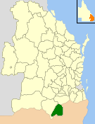
The Shire of Stanthorpe was a local government area of Queensland, Australia on the Queensland-New South Wales border. It was on the Great Dividing Range and was part of the Granite Belt. Its main industries included fruit and vegetable growing, wineries and tourism, and sheep and cattle grazing.

<span class="mw-page-title-main">Applethorpe, Queensland</span> Town in Queensland, Australia

Applethorpe is a rural town and locality in the Southern Downs Region, Queensland, Australia. It is on Queensland's border with New South Wales. It is well known for the production of apples. It often records the lowest temperatures in Queensland.

<span class="mw-page-title-main">Amiens, Queensland</span> Town in Queensland, Australia

Amiens is a rural locality in the Southern Downs Region, Queensland, Australia. In the 2016 census, Amiens had a population of 293 people.

<span class="mw-page-title-main">Ballandean, Queensland</span> Town in Queensland, Australia

Ballandean is a rural town and locality in the Southern Downs Region, Queensland, Australia. In the 2021 census, the locality of Ballandean had a population of 316 people.

<span class="mw-page-title-main">Dalveen, Queensland</span> Town in Queensland, Australia

Dalveen is a town and a locality in the Southern Downs Region, Queensland, Australia. It borders New South Wales. In the 2016 census, Dalveen had a population of 335 people.

<span class="mw-page-title-main">The Summit, Queensland</span> Town in Queensland, Australia

The Summit is a rural town and locality in the Southern Downs Region, Queensland, Australia. In the 2016 census, the locality of The Summit had a population of 409 people.

<span class="mw-page-title-main">Lyra, Queensland</span> Suburb of Southern Downs Region, Queensland, Australia

Lyra is a rural locality in the Southern Downs Region, Queensland, Australia. In the 2016 census, Lyra had a population of 53 people.

<span class="mw-page-title-main">Eukey</span> Suburb of Southern Downs Region, Queensland, Australia

Eukey is a rural locality in the Southern Downs Region, Queensland, Australia. It is on the border with New South Wales. In the 2016 census Eukey had a population of 134 people.

Pikedale is a rural locality in the Southern Downs Region, Queensland, Australia. In the 2016 census Pikedale had a population of 39 people.

Glen Aplin is a rural locality in the Southern Downs Region, Queensland, Australia. In the 2016 census, Glen Aplin had a population of 503 people.

Greenlands is a rural locality in the Southern Downs Region, Queensland, Australia. In the 2016 census Greenlands had a population of 250 people.

<span class="mw-page-title-main">Girraween, Queensland</span> Suburb of Southern Downs Region, Queensland, Australia

Girraween is an undeveloped locality in the Southern Downs Region, Queensland, Australia. It is in the Granite Belt and on the border with New South Wales. In the 2021 census, Girraween had a population of 5 people.

<span class="mw-page-title-main">Glen Niven, Queensland</span> Suburb of Southern Downs Region, Queensland, Australia

Glen Niven is a rural locality in the Southern Downs Region, Queensland, Australia. It is within the Granite Belt on the Darling Downs and adjacent to the border with New South Wales. In the 2021 census, Glen Niven had a population of 99 people.

Leslie is a rural locality in the Southern Downs Region, Queensland, Australia. In the 2021 census, Leslie had a population of 12 people.

<span class="mw-page-title-main">Massie, Queensland</span> Suburb of Southern Downs Region, Queensland, Australia

Massie is a rural locality in the Southern Downs Region, Queensland, Australia. In the 2021 census, Massie had a population of 113 people.

<span class="mw-page-title-main">Nandi, Queensland</span> Suburb of Western Downs Region, Queensland, Australia

Nandi is a rural locality in the Western Downs Region, Queensland, Australia. In the 2021 census, Nandi had a population of 105 people.

<span class="mw-page-title-main">Silverwood, Queensland</span> Suburb of Southern Downs Region, Queensland, Australia

Silverwood is a rural locality in the Southern Downs Region, Queensland, Australia. In the 2016 census, Silverwood had a population of 38 people.

Passchendaele is a rural locality in the Southern Downs Region, Queensland, Australia. In the 2016 census, Passchendaele had a population of 30 people.

Kings Creek is a rural locality in the Toowoomba Region, Queensland, Australia. In the 2021 census, Kings Creek had a population of 55 people.

References

  1. 1 2 3 Australian Bureau of Statistics (27 June 2017). "Fletcher (SSC)". 2016 Census QuickStats. Retrieved 20 October 2018. OOjs UI icon edit-ltr-progressive.svg
  2. "Fletcher – locality in Southern Downs Region (entry 50287)". Queensland Place Names. Queensland Government . Retrieved 19 September 2020.
  3. 1 2 3 "Queensland Globe". State of Queensland . Retrieved 29 October 2020.
  4. "Advertising". Warwick Examiner And Times . Vol. VI, no. 291. Queensland, Australia. 5 October 1872. p. 4. Retrieved 29 October 2020 via National Library of Australia.
  5. "STANTHORPE". The Queenslander . Vol. VII, no. 349. Queensland, Australia. 12 October 1872. p. 10. Retrieved 29 October 2020 via National Library of Australia.
  6. "Our Illustrations". The Queenslander . Queensland, Australia. 27 February 1892. p. 394. Retrieved 29 October 2020 via National Library of Australia.
  7. "Last Night's Telegrams". Toowoomba Chronicle and Darling Downs General Advertiser . No. 3109. Queensland, Australia. 10 December 1883. p. 2. Retrieved 29 October 2020 via National Library of Australia.
  8. ARCHAEO Cultural Heritage Services (November 2007). "Historical Cultural Heritage Survey of the proposed Emu Swamp Dam Project" (PDF). Queensland Government. p. 13. Archived (PDF) from the original on 13 April 2020. Retrieved 29 October 2020.
  9. "Fletcher – Railway station in the Southern Downs Region (entry 12756)". Queensland Place Names. Queensland Government . Retrieved 24 November 2018.
  10. "JUBILEE OF STANTHORPE". The Telegraph . No. 15, 346. Queensland, Australia. 2 February 1922. p. 3 (SECOND EDITION). Retrieved 29 October 2020 via National Library of Australia.