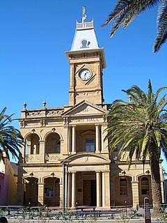
Stanthorpe is a rural town and locality in the Southern Downs Region, Queensland, Australia. In the 2016 census, Stanthorpe had a population of 5,406 people. The area surrounding the town is known as the Granite Belt.
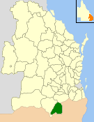
The Shire of Stanthorpe was a local government area of Queensland, Australia on the Queensland-New South Wales border. It was on the Great Dividing Range and was part of the Granite Belt. Its main industries included fruit and vegetable growing, wineries and tourism, and sheep and cattle grazing.

Thulimbah is a town and locality in the Southern Downs Region of Queensland, Australia. It borders New South Wales.
Dulacca is a town and a locality in the Western Downs Region, Queensland, Australia.

Hendon is a rural town and locality in the Southern Downs Region, Queensland, Australia. In the 2016 census, Hendon had a population of 200 people.
Applethorpe is a rural town and locality in the Southern Downs Region, Queensland, Australia. It is on the border with New South Wales. In the 2016 census, Applethorpe had a population of 511 people. Applethorpe is well known for the production of apples.

Amiens is a rural locality in the Southern Downs Region, Queensland, Australia. At the 2016 Australian Census, Amiens recorded a population of 293.

Ballandean is a small town and locality in the Granite Belt Region of the Southern Downs, Queensland, Australia. It is on the Queensland border with New South Wales. At the 2016 census the town recorded a population of 338. The town has a number of nearby vineyards which attracted tourists to the area.

Dalveen is a town and a locality in the Southern Downs Region, Queensland, Australia. It borders New South Wales. In the 2016 census, Dalveen had a population of 335 people.

Allan is a rural locality in the Southern Downs Region, Queensland, Australia. In the 2016 census, Allan had a population of 87 people.

Aubigny is a rural town and locality in the Toowoomba Region, Queensland, Australia. In the 2016 census, Aubigny had a population of 254 people.
Muntapa Tunnel is a heritage-listed tunnel from Narko-Nutgrove Road, Highgrove through to Nutgrove, both in the Toowoomba Region, Queensland, Australia. It was designed by Queensland Railways and built from 1910 to 1913 by Queensland Railways. It was added to the Queensland Heritage Register on 3 May 2007.

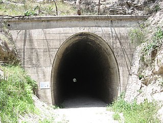
Cherry Gully Tunnel is a heritage-listed railway tunnel on the Warwick - Stanthorpe Line, Silverwood, Southern Downs Region, Queensland, Australia. It was built from 1878 to 1880 by J & A Overend & Co. It is also known as Gorge Tunnel and Big Tunnel. It was added to the Queensland Heritage Register on 28 July 2000.
Dalveen Tunnel is a heritage-listed tunnel on the Warwick to Wallangarra railway line, Dalveen, Southern Downs Region, Queensland, Australia. It was built from 1878 to 1880 by J Garget. It was added to the Queensland Heritage Register on 28 July 2000.
Lyra is a rural locality in the Southern Downs Region, Queensland, Australia. In the 2016 census, Lyra had a population of 53 people.
Pikedale is a locality in the Southern Downs Region, Queensland, Australia. It is one of the areas used for soldier settlements following service in World War I.
Severnlea is a locality in the Southern Downs Region, Queensland, Australia. In the 2016 census, Severnlea had a population of 350 people.
Cottonvale is a locality in the Southern Downs Region, Queensland, Australia. It borders New South Wales. In the 2016 census, Cottonvale had a population of 148 people. It contains the town of Cotton Vale.
Ducklo is a locality in the Western Downs Region, Queensland, Australia. In the 2016 census, Ducklo had a population of 333 people.
Cherry Gully is a locality in the Southern Downs Region, Queensland, Australia. In the 2016 census, Cherry Gully had a population of 9 people.
