
Girraween National Park is an area of the Granite Belt in the Darling Downs region of Queensland, Australia reserved as a national park. Girraween is known for its spectacular flowers, dramatic landscapes and unique wildlife. Bushwalking and rock climbing are the most popular activities in the park.

Stanthorpe is a rural town and locality in the Southern Downs Region, Queensland, Australia. In the 2021 census, the locality of Stanthorpe had a population of 5,286 people.

Wallangarra is a rural town and locality in the Southern Downs Region, Queensland, Australia on the border with New South Wales. In the 2016 census, the locality of Wallangarra had a population of 468 people.

The Granite Belt is an area of the Great Dividing Range in the Darling Downs region of Queensland and the New England region of New South Wales, Australia. The Granite Belt is centred on the town of Stanthorpe. The cool, high country of the granite belt is located on Queensland's southern border. It is the northernmost part of the New England Tablelands.
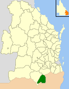
The Shire of Stanthorpe was a local government area of Queensland, Australia on the Queensland-New South Wales border. It was on the Great Dividing Range and was part of the Granite Belt. Its main industries included fruit and vegetable growing, wineries and tourism, and sheep and cattle grazing.

The County of Bentinck is a county located on the southern boundary of the state of Queensland, Australia. Like all counties in Queensland, it is a non-functional administrative unit, that is used mainly for the purpose of registering land titles. The county was named in 1838 after William Cavendish-Bentinck, 3rd Duke of Portland, who served as Prime Minister of Great Britain twice, in 1783 and again between 1807 and 1809. Population centres within the County of Bentinck include the towns of Stanthorpe, Wallangarra, Glen Aplin, Applethorpe and Inglewood.
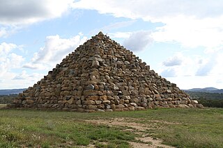
The Ballandean Pyramid is a man-made stone pyramid near the small village of Ballandean, Queensland, Australia. The pyramid is approximately 15 metres in height and built from blocks of the local granite. It is on private property belonging to a local vineyard and is approximately 25 metres from the nearest road.
Haden is a rural town and locality in the Toowoomba Region, Queensland, Australia. In the 2016 census, the locality of Haden had a population of 195 people.

Ballandean is a rural town and locality in the Southern Downs Region, Queensland, Australia. In the 2021 census, the locality of Ballandean had a population of 316 people.

Linthorpe is a rural locality in the Toowoomba Region, Queensland, Australia. In the 2021 census, Linthorpe had a population of 416 people.

Mount Irving is a rural locality in the Toowoomba Region, Queensland, Australia. In the 2021 census, Mount Irving had a population of 34 people.

Wallangarra railway station is a heritage-listed railway station at Woodlawn Street, Wallangarra, Southern Downs Region, Queensland, Australia. It was built in 1877 along the state border of Queensland and New South Wales It was added to the Queensland Heritage Register on 28 March 2003.

Ballandean Homestead is a heritage-listed homestead at Ballandean, Southern Downs Region, Queensland, Australia. It was built from c. 1840 to 1890s circa. It was added to the Queensland Heritage Register on 21 October 1992.

The Summit is a rural town and locality in the Southern Downs Region, Queensland, Australia. In the 2016 census, the locality of The Summit had a population of 409 people.
Lyra is a rural locality in the Southern Downs Region, Queensland, Australia. In the 2016 census, Lyra had a population of 53 people.
Eukey is a rural locality in the Southern Downs Region, Queensland, Australia. It is on the border with New South Wales. In the 2016 census Eukey had a population of 134 people.
Dalcouth is a locality in the Southern Downs Region, Queensland, Australia. It is on the border with New South Wales. In the 2021 census, Dalcouth had a population of 220 people.
Fletcher is a rural locality in the Southern Downs Region, Queensland, Australia. In the 2021 census, Fletcher had a population of 128 people.

Leslie Dam is a locality in the Southern Downs Region, Queensland, Australia. In the 2021 census, Leslie Dam had a population of 118 people.
Springdale is a rural locality in the Southern Downs Region, Queensland, Australia. In the 2021 census, Springdale had a population of 28 people.

