Cherry Gully, Queensland

Last updated

Cherry Gully
Queensland
Water Sculpture. Cherry Gully, South of Warwick, 2022.jpg
Water sculpture, Cherry Gully, 2022
Australia Queensland location map.svg
Red pog.svg
Cherry Gully
Coordinates 28°25′01″S152°03′29″E / 28.4169°S 152.0580°E / -28.4169; 152.0580 (Cherry Gully (centre of locality))
Population18 (SAL 2021) [1]
Postcode(s) 4370
Area15.9 km2 (6.1 sq mi)
Time zone AEST (UTC+10:00)
Location
LGA(s) Southern Downs Region
State electorate(s) Southern Downs
Federal division(s) Maranoa
Suburbs around Cherry Gully:
Silverwood Wildash Elbow Valley
Silverwood Cherry Gully Elbow Valley
Dalveen Elbow Valley Elbow Valley

Cherry Gully is a locality in the Southern Downs Region, Queensland, Australia. [2] In the 2021 census, Cherry Gully had a population of 18 people. [3]

Contents

History

The locality takes its name from a local gully name. There are a number of stories about the name of the gully. One story is that in mid-nineteenth century a cask of sherry fell from a wagon into the gully, with the word sherry being corrupted later to cherry. [2] In another story, carriers stopped at the gully and drank sherry from the cargo to excess and again the word sherry was corrupted to cherry. [4] The other story is that the gully has many wild cherry trees. [5]

Cherry Gully Provisional School opened in 1900. On 1 January 1909, it became Cherry Gully State School. It closed circa 1916. [6] It was on Old Stanthorpe Road ( 28°26′03″S152°01′59″E / 28.43417°S 152.03293°E / -28.43417; 152.03293 (Cherry Gully State School (former)) ), now within the neighbouring locality of Dalveen to the south-west. [7]

Demographics

In the 2016 census, Cherry Gully had a population of 9 people. [8]

In the 2021 census, Cherry Gully had a population of 18 people. [3]

Education

There are no schools in Cherry Gully. The nearest government primary school is Dalveen State School in neighbouring Dalveen to the south-west. The nearest government secondary school is Warwick State High School in Warwick to the north. [9]

Related Research Articles

<span class="mw-page-title-main">Maryvale, Queensland (Southern Downs Region)</span> Town in Queensland, Australia

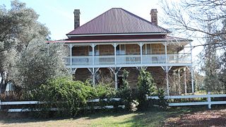
Maryvale is a rural town and locality in the Southern Downs Region, Queensland, Australia. In the 2016 census, the locality of Maryvale had a population of 303 people.

Hendon is a rural town and locality in the Southern Downs Region, Queensland, Australia. In the 2016 census, the locality of Hendon had a population of 200 people.

<span class="mw-page-title-main">Applethorpe, Queensland</span> Town in Queensland, Australia

Applethorpe is a rural town and locality in the Southern Downs Region, Queensland, Australia. It is on Queensland's border with New South Wales. It is well known for the production of apples. It often records the lowest temperatures in Queensland.

<span class="mw-page-title-main">Dalveen, Queensland</span> Town in Queensland, Australia

Dalveen is a town and a locality in the Southern Downs Region, Queensland, Australia. It borders New South Wales. In the 2016 census, Dalveen had a population of 335 people.

<span class="mw-page-title-main">Swan Creek, Queensland</span> Suburb of Southern Downs Region, Queensland, Australia

Swan Creek is a rural locality in the Southern Downs Region, Queensland, Australia. In the 2021 census, Swan Creek had a population of 161 people.

<span class="mw-page-title-main">Willowvale, Queensland</span> Suburb of Southern Downs Region, Queensland, Australia

Willowvale is a rural locality in the Southern Downs Region, Queensland, Australia. In the 2016 census Willowvale had a population of 94 people.

<span class="mw-page-title-main">Tannymorel, Queensland</span> Town in Queensland, Australia

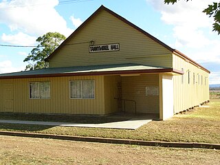
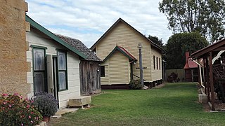
Tannymorel is a rural town and locality in the Southern Downs Region, Queensland, Australia. In the 2016 census, the locality of Tannymorel had a population of 161 people.

<span class="mw-page-title-main">Mount Marshall, Queensland</span> Suburb of Southern Downs Region, Queensland, Australia

Mount Marshall is a rural locality in the Southern Downs Region, Queensland, Australia. In the 2016 census, Mount Marshall had a population of 243 people.

<span class="mw-page-title-main">Tregony, Queensland</span> Suburb of Southern Downs Region, Queensland, Australia

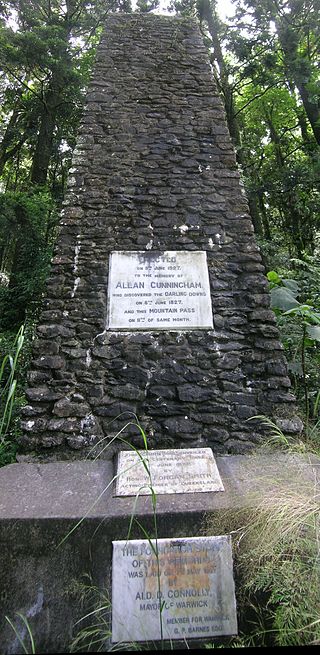
Tregony is a locality in the Southern Downs Region, Queensland, Australia. It is one of the major gateways to the Darling Downs from the Queensland coast. In the 2021 census, Tregony had a population of 36 people.

<span class="mw-page-title-main">Mulgowie, Queensland</span> Suburb of Lockyer Valley Region, Queensland, Australia

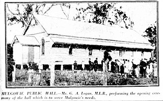
Mulgowie is a rural locality in the Lockyer Valley Region, Queensland, Australia. In the 2021 census, Mulgowie had a population of 166 people.

<span class="mw-page-title-main">Clintonvale, Queensland</span> Suburb of Southern Downs Region, Queensland, Australia

Clintonvale is a rural locality in the Southern Downs Region, Queensland, Australia. In the 2016 census, Clintonvale had a population of 74 people.

Cottonvale is a locality in the Southern Downs Region, Queensland, Australia. It borders New South Wales. In the 2016 census, Cottonvale had a population of 148 people. It contains the town of Cotton Vale.

Elbow Valley is a rural locality in the Southern Downs Region, Queensland, Australia. It is on the border of New South Wales. In the 2016 census, Elbow Valley had a population of 95 people.

Loch Lomond is a rural locality in the Southern Downs Region, Queensland, Australia. In the 2016 census, Loch Lomond had a population of 106 people.

Bogandilla is a rural locality in the Western Downs Region, Queensland, Australia. In the 2021 census, Bogandilla had a population of 37 people.

Bundi is a rural locality in the Western Downs Region, Queensland, Australia. In the 2021 census, Bundi had a population of 52 people.

Blaxland is a rural locality in the Western Downs Region, Queensland, Australia. In the 2021 census, Blaxland had a population of 58 people.

Ivory Creek is a rural locality in the Somerset Region, Queensland, Australia. In the 2021 census, Ivory Creek had a population of 49 people.

Mount Hallen is a rural locality in the Somerset Region, Queensland, Australia. In the 2021 census, Mount Hallen had a population of 457 people.

<span class="mw-page-title-main">Silverwood, Queensland</span> Suburb of Southern Downs Region, Queensland, Australia

Silverwood is a rural locality in the Southern Downs Region, Queensland, Australia. In the 2016 census, Silverwood had a population of 38 people.

References

  1. Australian Bureau of Statistics (28 June 2022). "Cherry Gully (Suburb and Locality)". Australian Census 2021 QuickStats. Retrieved 28 June 2022.  OOjs UI icon edit-ltr-progressive.svg
  2. 1 2 "Cherry Gully – locality in Southern Downs Region (entry 47647)". Queensland Place Names. Queensland Government . Retrieved 24 November 2018.
  3. 1 2 Australian Bureau of Statistics (28 June 2022). "Cherry Gully (SAL)". 2021 Census QuickStats. Retrieved 28 February 2023. OOjs UI icon edit-ltr-progressive.svg
  4. "CHERRY OR SHERRY GULLY". The Courier-mail . No. 738. Queensland, Australia. 10 January 1936. p. 12. Archived from the original on 30 August 2023. Retrieved 24 November 2018 via National Library of Australia.
  5. "NOMENCLATURE OF QUEENSLAND.—84". The Courier-mail . No. 734. Queensland, Australia. 6 January 1936. p. 10. Archived from the original on 30 August 2023. Retrieved 24 November 2018 via National Library of Australia.
  6. Queensland Family History Society (2010), Queensland schools past and present (Version 1.01 ed.), Queensland Family History Society, ISBN   978-1-921171-26-0
  7. "County of Merivale" (Map). Queensland Government. 1923. Archived from the original on 30 August 2023. Retrieved 30 August 2023.
  8. Australian Bureau of Statistics (27 June 2017). "Cherry Gully (SSC)". 2016 Census QuickStats. Retrieved 20 October 2018. OOjs UI icon edit-ltr-progressive.svg
  9. "Queensland Globe". State of Queensland . Retrieved 30 August 2023.