Elbow Valley, Queensland

Last updated

Elbow Valley
Queensland
Australia Queensland location map.svg
Red pog.svg
Elbow Valley
Coordinates 28°24′33″S152°10′01″E / 28.4091°S 152.1669°E / -28.4091; 152.1669 (Elbow Valley (centre of locality))
Population127 (2021 census) [1]
 • Density0.794/km2 (2.056/sq mi)
Postcode(s) 4370
Area160.0 km2 (61.8 sq mi)
Time zone AEST (UTC+10:00)
LGA(s) Southern Downs Region
State electorate(s) Southern Downs
Federal division(s) Maranoa
Suburbs around Elbow Valley:
Wildash Murrays Bridge Loch Lomond
Killarney
Cherry Gully Elbow Valley Legume (NSW)
Lower Acacia Creek (NSW)
Dalveen Maryland (NSW) Cullendore (NSW)

Elbow Valley is a rural locality in the Southern Downs Region, Queensland, Australia. [2] It is on the border of New South Wales. [3] In the 2021 census, Elbow Valley had a population of 127 people. [1]

Contents

History

The locality presumably takes its name from the Elbow River, which was named by botanist and explorer Allan Cunningham in his field notes on 6 June 1827. [2]

Elbow Valley Provisional School opened on 17 July 1882 at Kirbys Crossing, later relocating to Cullendore Road, and then in 1905 relocating to its permanent site at 105 O'Deas Road ( 28°23′15″S152°07′43″E / 28.3876°S 152.1287°E / -28.3876; 152.1287 (Elbow Valley State School (former)) ). [4] On 1 January 1909, it became Elbow Valley State School. It closed in 1946. [5] In 1952, the school building was relocated to the St George area. [6] [3]

The Sacred Heart Catholic Church was officially opened on 10 June 1906 by the Reverend M. M. Potter. [7] It was at 27 Church Lane (approx 28°23′36″S152°07′40″E / 28.3932°S 152.1277°E / -28.3932; 152.1277 (Sacred Heart Catholic Church (former)) ). It closed in 1982 and is now used as a house. It is listed on the Southern Downs Local Heritage Register. [8] [9]

Westmore State School opened on 1916 and closed on 1923. [10] This school described as 7 miles (11 km) from Killarney was presumably in the vicinity of Westmore Road ( 28°22′40″S152°11′52″E / 28.3777°S 152.1977°E / -28.3777; 152.1977 (Westmore Road, Elbow Bend) ) and the Westmoor pastoral property, and may have been associated with the Westmore Cheese factory which opened in January 1914 and was 14 mile (400 m) from the school. [11] [12] It was a "tent school" and officially opened on 1 July 1916 by Francis Grayson, Member of the Queensland Legislative Assembly for Cunningham, with food provided by the cheese factory. [13] [14] In June 1927, the Queensland Government called for tenders to remove the school building. [15]

Demographics

In the 2016 census, Elbow Valley had a population of 95 people. [16]

In the 2021 census, Elbow Valley had a population of 127 people. [1]

Education

There are no schools in Elbow Valley. The nearest government primary schools are Murrays Bridge State School in neighbouring Murrays Bridge to the north, Killarney State School in neighbouring Killarney to the north-east, and Dalveen State School in neighbouring Dalveen to the south-west. The nearest government secondary schools are Killarney State School (to Year 10), Warwick State High School (to Year 12) in Warwick to the north, and Stanthorpe State High School (to Year 12) in Stanthorpe to the south-west. [3]

Related Research Articles

<span class="mw-page-title-main">Killarney, Queensland</span> Town in Queensland, Australia

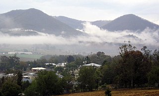
Killarney is a rural town and locality in the Southern Downs Region, Queensland, Australia. It borders New South Wales. In the 2021 census, the locality of Killarney had a population of 918 people.

<span class="mw-page-title-main">Southern Downs Region</span> Local government area in Queensland, Australia

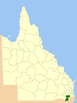
The Southern Downs Region is a local government area in the Darling Downs region of Queensland, Australia, along the state's boundary with New South Wales. It was created in 2008 from a merger of the Shire of Warwick and the Shire of Stanthorpe.

<span class="mw-page-title-main">Killarney railway line</span> Former railway line in Queensland

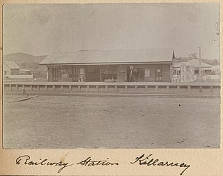
The Killarney railway line was a branch railway in the Darling Downs region of Queensland, Australia. It travelled from Warwick to Killarney and operated from 1884 to 1964.

<span class="mw-page-title-main">Southern railway line, Queensland</span> Railway line in Queensland, Australia

The Southern railway line serves the Darling Downs region of Queensland, Australia. The 197-kilometre (122 mi) long line branches from the Western line at Toowoomba, 161 kilometres (100 mi) west of Brisbane, and proceeds south through Warwick and Stanthorpe to the New South Wales/Queensland state border at Wallangarra.

<span class="mw-page-title-main">Dalveen, Queensland</span> Town in Queensland, Australia

Dalveen is a town and a locality in the Southern Downs Region, Queensland, Australia. It borders New South Wales. In the 2016 census, Dalveen had a population of 335 people.

<span class="mw-page-title-main">Swan Creek, Queensland</span> Suburb of Southern Downs Region, Queensland, Australia

Swan Creek is a rural locality in the Southern Downs Region, Queensland, Australia. In the 2021 census, Swan Creek had a population of 161 people.

<span class="mw-page-title-main">Yangan, Queensland</span> Town in Queensland, Australia

Yangan is a rural town and locality in the Southern Downs Region, Queensland, Australia. In the 2021 census, the locality of Yangan had a population of 404 people.

<span class="mw-page-title-main">Tannymorel, Queensland</span> Town in Queensland, Australia

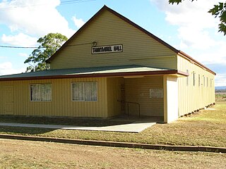
Tannymorel is a rural town and locality in the Southern Downs Region, Queensland, Australia. In the 2016 census, the locality of Tannymorel had a population of 161 people.

Murrays Bridge is a rural locality in the Southern Downs Region, Queensland, Australia. In the 2016 census Murrays Bridge had a population of 103 people.

<span class="mw-page-title-main">Danderoo, Queensland</span> Suburb of Southern Downs Region, Queensland, Australia

Danderoo is a rural locality in the Southern Downs Region, Queensland, Australia. In the 2021 census, Danderoo had a population of 40 people.

<span class="mw-page-title-main">Emu Vale, Queensland</span> Town in Queensland, Australia

Emu Vale is a rural town and locality in the Southern Downs Region, Queensland, Australia. In the 2021 census, the locality of Emu Vale had a population of 161 people.

Wildash is a rural locality in the Southern Downs Region, Queensland, Australia. In the 2016 census, Wildash had a population of 66 people.

<span class="mw-page-title-main">Junabee</span> Suburb of Southern Downs Region, Queensland, Australia

Junabee is a rural locality in the Southern Downs Region, Queensland, Australia. In the 2021 census, Junabee had a population of 195 people.

Loch Lomond is a rural locality in the Southern Downs Region, Queensland, Australia. In the 2016 census, Loch Lomond had a population of 106 people.

<span class="mw-page-title-main">Cherry Gully, Queensland</span> Suburb of Southern Downs Region, Queensland, Australia

Cherry Gully is a rural locality in the Southern Downs Region, Queensland, Australia. In the 2021 census, Cherry Gully had a population of 18 people.

Fletcher is a rural locality in the Southern Downs Region, Queensland, Australia. In the 2021 census, Fletcher had a population of 128 people.

<span class="mw-page-title-main">Silverwood, Queensland</span> Suburb of Southern Downs Region, Queensland, Australia

Silverwood is a rural locality in the Southern Downs Region, Queensland, Australia. In the 2021 census, Silverwood had a population of 58 people.

Morgan Park is a rural locality in the Southern Downs Region, Queensland, Australia. In the 2021 census, Morgan Park had a population of 98 people.

Wiyarra is a rural locality in the Southern Downs Region, Queensland, Australia. In the 2021 census, Wiyarra had a population of 20 people.

Mount Sturt is a rural locality in the Southern Downs Region, Queensland, Australia. In the 2021 census, Mount Sturt had a population of 14 people.

References

  1. 1 2 3 Australian Bureau of Statistics (28 June 2022). "Elbow Valley (SAL)". 2021 Census QuickStats. Retrieved 28 February 2023. OOjs UI icon edit-ltr-progressive.svg
  2. 1 2 "Elbow Valley – locality in Southern Downs Region (entry 49856)". Queensland Place Names. Queensland Government . Retrieved 29 December 2020.
  3. 1 2 3 "Queensland Globe". State of Queensland . Retrieved 17 December 2023.
  4. "Queensland Two Mile series sheet 2m7" (Map). Queensland Government. 1947. Retrieved 28 August 2022.
  5. Queensland Family History Society (2010), Queensland schools past and present (Version 1.01 ed.), Queensland Family History Society, ISBN   978-1-921171-26-0
  6. Baker, Mark (2010). Southern Downs Cultural Heritage Study - Inventory of Surveyed Places. Southern Downs Regional Council. p. 204.
  7. "COUNTRY NEWS". The Queenslander . No. 2101. Queensland, Australia. 16 June 1906. p. 10. Retrieved 17 December 2023 via National Library of Australia.
  8. "Sacred Heart Catholic Church | Elbow Valley". Queensland Religious Places Database. Retrieved 16 December 2023.
  9. "Southern Downs Local Heritage Register" (PDF). Southern Downs Regional Council. 23 June 2021. p. 8. Retrieved 17 December 2023.
  10. Queensland Family History Society (2010), Queensland schools past and present (Version 1.01 ed.), Queensland Family History Society, ISBN   978-1-921171-26-0
  11. "NEW CHEESE FACTORY". Warwick Examiner And Times . No. 4529. Queensland, Australia. 17 January 1914. p. 5. Retrieved 19 November 2019 via National Library of Australia.
  12. "KILLARNEY". Warwick Examiner And Times . No. 4769. Queensland, Australia. 29 September 1915. p. 2. Retrieved 19 November 2019 via National Library of Australia.
  13. "WESTMORE TENT SCHOOL". Warwick Examiner And Times . No. 4882. Queensland, Australia. 3 July 1916. p. 5. Retrieved 19 November 2019 via National Library of Australia.
  14. "WARWICK AND DISTRICT". The Brisbane Courier . No. 18, 241. Queensland, Australia. 4 July 1916. p. 9. Retrieved 19 November 2019 via National Library of Australia.
  15. "WESTMORE SCHOOL BUILDING". Warwick Daily News . No. 2503. Queensland, Australia. 29 June 1927. p. 4. Retrieved 19 November 2019 via National Library of Australia.
  16. Australian Bureau of Statistics (27 June 2017). "Elbow Valley (SSC)". 2016 Census QuickStats. Retrieved 20 October 2018. OOjs UI icon edit-ltr-progressive.svg

Further reading