Greenlands, Queensland

Last updated

Greenlands
Queensland
Australia Queensland location map.svg
Red pog.svg
Greenlands
Coordinates 28°39′12″S151°47′11″E / 28.6533°S 151.7863°E / -28.6533; 151.7863 (Greenlands (centre of locality))
Population244 (2021 census) [1]
 • Density4.000/km2 (10.360/sq mi)
Postcode(s) 4380
Area61.0 km2 (23.6 sq mi)
Time zone AEST (UTC+10:00)
LGA(s) Southern Downs Region
State electorate(s) Southern Downs
Federal division(s) Maranoa
Suburbs around Greenlands:
Pikedale Amiens Amiens
Pikedale Greenlands Broadwater
Nundubbermere Nundubbermere Thorndale

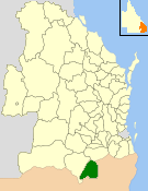
Greenlands is a rural locality in the Southern Downs Region, Queensland, Australia. [2] In the 2021 census, Greenlands had a population of 244 people. [1]

Contents

Geography

Stanthorpe – Texas Road passes from east to west through the locality. [3]

History

Bertram (Jack) Greenland, 1872 StateLibQld 1 180015 Bertram (Jack) Greenland, building contractor in Stanthorpe, 1872.jpg
Bertram (Jack) Greenland, 1872

The locality is named after Bertram (Jack) Greenland, a building contractor in Stanthorpe. [4]

Thorndale State School opened in 1915. It was relocated to a new location near Spring Creek in 1924 and opened on 12 November 1924 as Greenlands State School. (Note another Thorndale State School opened in neighbouring Thorndale in 1945). [5]

Demographics

In the 2016 census Greenlands had a population of 250 people. [6]

In the 2021 census, Greenlands had a population of 244 people. [1]

Education

Greenlands State School is a government primary (Prep-6) school for boys and girls at 1209 Texas Road ( 28°39′39″S151°49′39″E / 28.6608°S 151.8274°E / -28.6608; 151.8274 (Greenlands State School) ). [7] [8] In 2016, the school had enrolment of 106 students with 8 teachers (6 full-time equivalent) with 9 non-teaching staff (4 full-time equivalent). [9] In 2018, the school had an enrolment of 108 students with 8 teachers (6 full-time equivalent) and 8 non-teaching staff (4 full-time equivalent). [10]

Related Research Articles

<span class="mw-page-title-main">Stanthorpe, Queensland</span> Town in Queensland, Australia

Stanthorpe is a rural town and locality in the Southern Downs Region, Queensland, Australia. In the 2021 census, the locality of Stanthorpe had a population of 5,286 people.

<span class="mw-page-title-main">Highfields, Queensland</span> Suburb of Toowoomba Region, Queensland, Australia

Highfields is a town and locality in the Toowoomba Region, Queensland, Australia. In the 2021 census, the locality of Highfields had a population of 8,568 people.

<span class="mw-page-title-main">Leyburn, Queensland</span> Town in Queensland, Australia

Leyburn is a rural town in the Southern Downs Region and a locality split between the South Downs Region and the Toowoomba Region in Queensland, Australia. In the 2016 census, Leyburn had a population of 476 people.

<span class="mw-page-title-main">Thulimbah, Queensland</span> Town in Queensland, Australia

Thulimbah is a rural town and locality in the Southern Downs Region, Queensland, Australia. In the 2016 census the locality of Thulimbah had a population of 319 people. It borders New South Wales.

<span class="mw-page-title-main">Karara, Queensland</span> Town in Queensland, Australia

Karara is a rural town and locality in the Southern Downs Region, Queensland, Australia. In the 2016 census, the locality of Karara had a population of 123 people.

<span class="mw-page-title-main">Harristown, Queensland</span> Suburb of Toowoomba, Queensland, Australia

Harristown is a residential locality in Toowoomba in the Toowoomba Region, Queensland, Australia. In the 2021 census, Harristown had a population of 9,081 people.

<span class="mw-page-title-main">Applethorpe, Queensland</span> Town in Queensland, Australia

Applethorpe is a rural town and locality in the Southern Downs Region, Queensland, Australia. It is on Queensland's border with New South Wales. It is well known for the production of apples. It often records the lowest temperatures in Queensland.

<span class="mw-page-title-main">Amiens, Queensland</span> Town in Queensland, Australia

Amiens is a rural locality in the Southern Downs Region, Queensland, Australia. In the 2016 census, Amiens had a population of 293 people.

<span class="mw-page-title-main">Ballandean, Queensland</span> Town in Queensland, Australia

Ballandean is a rural town and locality in the Southern Downs Region, Queensland, Australia. In the 2021 census, the locality of Ballandean had a population of 316 people.

<span class="mw-page-title-main">Dalveen, Queensland</span> Town in Queensland, Australia

Dalveen is a town and a locality in the Southern Downs Region, Queensland, Australia. It borders New South Wales. In the 2016 census, Dalveen had a population of 335 people.

<span class="mw-page-title-main">Southbrook, Queensland</span> Town in Queensland, Australia

Southbrook is a rural town and locality in the Toowoomba Region, Queensland, Australia. In the 2021 census, the locality of Southbrook had a population of 626 people.

<span class="mw-page-title-main">The Summit, Queensland</span> Town in Queensland, Australia

The Summit is a rural town and locality in the Southern Downs Region, Queensland, Australia. In the 2016 census, the locality of The Summit had a population of 409 people.

<span class="mw-page-title-main">Brookstead, Queensland</span> Town in Queensland, Australia

Brookstead is a rural town and locality in the Toowoomba Region, Queensland, Australia. In the 2016 census, Brookstead had a population of 217 people.

Broadwater is a rural locality in the Southern Downs Region, Queensland, Australia. In the 2021 census, Broadwater had a population of 321 people.

Wheatvale is a rural locality in the Southern Downs Region, Queensland, Australia. In the 2016 census, Wheatvale had a population of 56 people.

<span class="mw-page-title-main">Severnlea, Queensland</span> Suburb of Southern Downs Region, Queensland, Australia

Severnlea is a semi-rural locality in the Southern Downs Region, Queensland, Australia. In the 2021 census, Severnlea had a population of 382 people.

Glen Aplin is a rural locality in the Southern Downs Region, Queensland, Australia. In the 2021 census, Glen Aplin had a population of 566 people.

Pozieres is a rural locality in the Southern Downs Region, Queensland, Australia. In the 2016 census Pozieres had a population of 145 people.

Thorndale is a rural locality in the Southern Downs Region, Queensland, Australia. In the 2016 census Thorndale had a population of 150 people.

Springdale is a rural locality in the Southern Downs Region, Queensland, Australia. In the 2021 census, Springdale had a population of 28 people.

References

  1. 1 2 3 Australian Bureau of Statistics (28 June 2022). "Greenlands (SAL)". 2021 Census QuickStats. Retrieved 28 February 2023. OOjs UI icon edit-ltr-progressive.svg
  2. "Greenlands – locality in Southern Downs Region (entry 50092)". Queensland Place Names. Queensland Government . Retrieved 29 December 2020.
  3. "Queensland Globe". State of Queensland . Retrieved 19 September 2017.
  4. Unidentified (1872), Bertram (Jack) Greenland, building contractor in Stanthorpe, 1872, John Oxley Library, State Library of Queensland, retrieved 19 September 2017
  5. Queensland Family History Society (2010), Queensland schools past and present (Version 1.01 ed.), Queensland Family History Society, ISBN   978-1-921171-26-0
  6. Australian Bureau of Statistics (27 June 2017). "Greenlands (SSC)". 2016 Census QuickStats. Retrieved 20 October 2018. OOjs UI icon edit-ltr-progressive.svg
  7. "State and non-state school details". Queensland Government. 9 July 2018. Archived from the original on 21 November 2018. Retrieved 21 November 2018.
  8. "Greenlands State School" . Retrieved 28 September 2023.
  9. "Annual Report 2016" (PDF). Greenlands State School. Archived (PDF) from the original on 19 September 2017. Retrieved 19 September 2017.
  10. "ACARA School Profile 2018". Australian Curriculum, Assessment and Reporting Authority . Retrieved 28 January 2020.

Further reading