Mount Sturt, Queensland

Last updated

Mount Sturt
Queensland
Australia Queensland location map.svg
Red pog.svg
Mount Sturt
Coordinates 28°10′12″S152°12′28″E / 28.17°S 152.2077°E / -28.17; 152.2077 (Mount Sturt (centre of locality))
Population14 (SAL 2021) [1]
Postcode(s) 4370
Area9.3 km2 (3.6 sq mi)
Time zone AEST (UTC+10:00)
Location
LGA(s) Southern Downs Region
State electorate(s) Southern Downs
Federal division(s) Maranoa
Suburbs around Mount Sturt:
Freestone Upper Freestone Swanfels
Freestone Mount Sturt Swanfels
Yangan Yangan Yangan

Mount Sturt is a rural locality in the Southern Downs Region, Queensland, Australia. [2] In the 2021 census, Mount Sturt had a population of 14 people. [3]

Contents

Geography

Mount Sturt is a mountain in the centre of the locality ( 28°10′06″S152°11′56″E / 28.1682°S 152.1988°E / -28.1682; 152.1988 (Mount Sturt) ) rising to 894 metres (2,933 ft) above sea level. [4] [5]

The land use is a mixture of grazing on native vegetation and crop growing. [6]

History

The locality takes its name from a railway station, which is named for the mountain, which in turn was named in June 1827 by explorer Allan Cunningham after the explorer Charles Sturt. [2] [7]

The Killarney railway line opened from Warwick to Emu Vale on 2 June 1884 which included the Mount Sturt railway station. [8] [9] The line closed on 1 May 1964. [8] Despite the name, the Mount Sturt railway station was not within the present-day locality of Mount Sturt but with the present-day locality of Yangan. [10]

Demographics

In the 2016 census, Mount Sturt had a population of 18 people. [11]

In the 2021 census, Mount Sturt had a population of 14 people. [3]

Education

There are no schools in Mount Sturt. The nearest government primary schools are Yangan State School in neighbouring Yangan to the south and Freestone State School in neighbouring Freestone to the north-west. The nearest government secondary school is Warwick State High School in Warwick to the southwest. [12]

Related Research Articles

<span class="mw-page-title-main">Killarney, Queensland</span> Town in Queensland, Australia

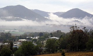
Killarney is a rural town and locality in the Southern Downs Region, Queensland, Australia. It borders New South Wales. In the 2016 census, the locality of Killarney had a population of 954 people.

<span class="mw-page-title-main">Killarney railway line</span> Former railway line in Queensland

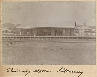
The Killarney railway line was a branch railway in the Darling Downs region of Queensland, Australia. It travelled from Warwick to Killarney and operated from 1884 to 1964.

<span class="mw-page-title-main">Maryvale, Queensland (Southern Downs Region)</span> Town in Queensland, Australia

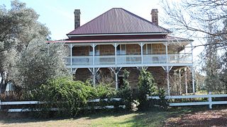
Maryvale is a rural town and locality in the Southern Downs Region, Queensland, Australia. In the 2016 census, the locality of Maryvale had a population of 303 people.

<span class="mw-page-title-main">Glengallan, Queensland</span> Suburb of Southern Downs Region, Queensland, Australia

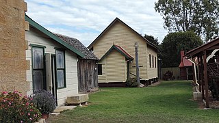
Glengallan is a rural locality in the Southern Downs Region, Queensland, Australia. In the 2021 census, Glengallan had a population of 57 people.

<span class="mw-page-title-main">Swan Creek, Queensland</span> Suburb of Southern Downs Region, Queensland, Australia

Swan Creek is a rural locality in the Southern Downs Region, Queensland, Australia. In the 2021 census, Swan Creek had a population of 161 people.

<span class="mw-page-title-main">Yangan, Queensland</span> Town in Queensland, Australia

Yangan is a rural town and locality in the Southern Downs Region, Queensland, Australia. In the 2021 census, the locality of Yangan had a population of 404 people.

<span class="mw-page-title-main">Willowvale, Queensland</span> Suburb of Southern Downs Region, Queensland, Australia

Willowvale is a rural locality in the Southern Downs Region, Queensland, Australia. In the 2016 census Willowvale had a population of 94 people.

<span class="mw-page-title-main">Tannymorel, Queensland</span> Town in Queensland, Australia

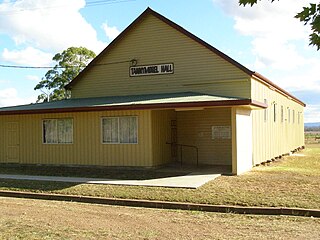
Tannymorel is a rural town and locality in the Southern Downs Region, Queensland, Australia. In the 2016 census, the locality of Tannymorel had a population of 161 people.

<span class="mw-page-title-main">Mount Marshall, Queensland</span> Suburb of Southern Downs Region, Queensland, Australia

Mount Marshall is a rural locality in the Southern Downs Region, Queensland, Australia. In the 2016 census, Mount Marshall had a population of 243 people.

<span class="mw-page-title-main">Freestone, Queensland</span> Town in Queensland, Australia

Freestone is a rural town and locality in the Southern Downs Region, Queensland, Australia. In the 2016 census, Freestone had a population of 217 people.

<span class="mw-page-title-main">Clintonvale, Queensland</span> Suburb of Southern Downs Region, Queensland, Australia

Clintonvale is a rural locality in the Southern Downs Region, Queensland, Australia. In the 2016 census, Clintonvale had a population of 74 people.

Danderoo is a rural locality in the Southern Downs Region, Queensland, Australia. In the 2016 census, Danderoo had a population of 30 people.

Elbow Valley is a rural locality in the Southern Downs Region, Queensland, Australia. It is on the border of New South Wales. In the 2016 census, Elbow Valley had a population of 95 people.

<span class="mw-page-title-main">Emu Vale, Queensland</span> Town in Queensland, Australia

Emu Vale is a rural town and locality in the Southern Downs Region, Queensland, Australia. In the 2016 census, Emu Vale had a population of 185 people.

<span class="mw-page-title-main">Upper Freestone, Queensland</span> Suburb of Southern Downs Region, Queensland, Australia

Upper Freestone is a rural locality in the Southern Downs Region, Queensland, Australia. In the 2016 census, Upper Freestone had a population of 90 people.

<span class="mw-page-title-main">Junabee</span> Suburb of Southern Downs Region, Queensland, Australia

Junabee is a rural locality in the Southern Downs Region, Queensland, Australia. In the 2016 census, Junabee had a population of 213 people.

Loch Lomond is a rural locality in the Southern Downs Region, Queensland, Australia. In the 2016 census, Loch Lomond had a population of 106 people.

The Hermitage is a locality in the Southern Downs Region, Queensland, Australia. In the 2016 census, The Hermitage had a population of 54 people.

<span class="mw-page-title-main">Silverwood, Queensland</span> Suburb of Southern Downs Region, Queensland, Australia

Silverwood is a rural locality in the Southern Downs Region, Queensland, Australia. In the 2016 census, Silverwood had a population of 38 people.

Morgan Park is a rural locality in the Southern Downs Region, Queensland, Australia. In the 2021 census, Morgan Park had a population of 98 people.

References

  1. Australian Bureau of Statistics (28 June 2022). "Mount Sturt (suburb and locality)". Australian Census 2021 QuickStats. Retrieved 28 June 2022.  OOjs UI icon edit-ltr-progressive.svg
  2. 1 2 "Mount Sturt – locality in Southern Downs Region (entry 45957)". Queensland Place Names. Queensland Government . Retrieved 11 June 2019.
  3. 1 2 Australian Bureau of Statistics (28 June 2022). "Mount Sturt (SAL)". 2021 Census QuickStats. Retrieved 28 February 2023. OOjs UI icon edit-ltr-progressive.svg
  4. "Mountain peaks and capes - Queensland". Queensland Open Data. Queensland Government. 12 November 2020. Archived from the original on 25 November 2020. Retrieved 25 November 2020.
  5. "Mount Sturt – mountain in Southern Downs Region (entry 32715)". Queensland Place Names. Queensland Government . Retrieved 25 November 2020.
  6. "Queensland Globe". State of Queensland . Retrieved 11 December 2023.
  7. "Mount Sturt – mountain in the Southern Downs Region (entry 32715)". Queensland Place Names. Queensland Government . Retrieved 23 October 2019.
  8. 1 2 Southern Downs Steam Railway (2008). "Historical information: Warwick – Killarney". Archived from the original on 12 September 2009. Retrieved 17 November 2008.
  9. "The Killarney Branch Line,". Darling Downs Gazette . Vol. XXIII, no. 5, 627. Queensland, Australia. 31 March 1884. p. 3. Retrieved 11 December 2023 via National Library of Australia.
  10. "Item ID622930, Parish of Robinson, County of Merivale. ca. 40 chains to the inch. Survey Office, Brisbane (1921 Map)". Queensland State Archives . Retrieved 11 December 2023.
  11. Australian Bureau of Statistics (27 June 2017). "Mount Sturt (SSC)". 2016 Census QuickStats. Retrieved 20 October 2018. OOjs UI icon edit-ltr-progressive.svg
  12. "Layers: Locality; Schools and school catchments". Queensland Globe. Queensland Government . Retrieved 11 December 2023.