Cunningham, Queensland

Last updated

Cunningham
Queensland
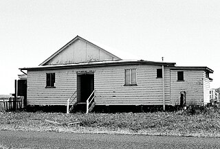
Country Women's Association Memorial Hall, Cunningham, 2015.JPG
Country Women's Association Memorial Hall, Cunningham, 2015
Australia Queensland location map.svg
Red pog.svg
Cunningham
Coordinates 28°09′34″S151°50′08″E / 28.15944°S 151.83556°E / -28.15944; 151.83556 Coordinates: 28°09′34″S151°50′08″E / 28.15944°S 151.83556°E / -28.15944; 151.83556
Postcode(s) 4370
LGA(s) Southern Downs Region
State electorate(s) Southern Downs
Federal Division(s) Maranoa
Suburbs around Cunningham:
Pratten Upper Wheatvale Wheatvale
Montrose Cunningham Wheatvale
Greymare Rodgers Creek Rodgers Creek

Cunningham is a locality in the Southern Downs Region, Queensland, Australia. [1]

Contents

History

The locality is named after explorer and botanist Allan Cunningham who was the first European to see the lush pastures of the Darling Downs in 1827. [1]

Geography

The Condamine River forms the north-eastern boundary of the locality. The Cunningham Highway passes through the locality in an approximately east-west direction and forms part of the southern boundary. The South Western railway line passes through the locality from the north-east to the south-west. The land is mostly used for farming. There is a small urban centre on the Leyburn-Cunningham Road which features the Country Women's Association Memorial Hall at Cunningham Road, [2] a memorial park and the now disused Cunningham railway station. [3]

Amenities

Memorial park, 2015 Memorial park, Cunningham, Queensland, 2015.JPG
Memorial park, 2015
Memorial to Patrick Leslie, Cunningham, 2015 Memorial to Patrick Leslie, Cunningham, 2015.JPG
Memorial to Patrick Leslie, Cunningham, 2015
War memorial, Cunningham, 2015 War memorial, Cunningham, 2015.JPG
War memorial, Cunningham, 2015
Monument to local pioneering families, 2015 Monument to local pioneering families (Clancy, Mullins, McMahon, Cantwell), memorial park, Cunningham, 2015 03.JPG
Monument to local pioneering families, 2015

The memorial park has a picnic table as well as three memorials to (left to right):

The memorial cairn to Patrick Leslie was erected by the Rosenthal Shire Council and unveiled on 10 December 1959 by the Shire Chairman, J. A. Costello. [4]

The Cunningham branch of the Queensland Country Women's Association meets at the QCWA Hall on Cunningham Road. [5]

Related Research Articles

Nobby, Queensland Town in Queensland, Australia

Nobby is a rural town and locality on the Darling Downs in the Toowoomba Region, Queensland, Australia. It is located halfway between Toowoomba and Warwick. In the 2016 census, Nobby had a population of 563 people.

Pittsworth, Queensland Town in Queensland, Australia

Pittsworth is a town and locality in Toowoomba Region, Queensland, Australia. According to the Australian Bureau of Statistics, results from the 2016 Census showed that Pittsworth had a population of 3,294.

Highfields, Queensland Town in Queensland, Australia

Highfields is both a town and a locality in the Toowoomba Region, Queensland, Australia. At the 2016 census, Highfields had a population of 8,131. At June 2015, the estimated urban population for the Highfields urban area was 18,771. It is the fastest growing area in Queensland and also one of the fastest in Australia.

Allora, Queensland Town in Queensland, Australia

Allora is a rural town and locality in the Southern Downs Region, Queensland, Australia. In the 2016 census, Allora had a population of 1,223 people.

Thallon, Queensland Town in Queensland, Australia

Thallon is a town and a locality in the Shire of Balonne, Queensland, Australia. In the 2016 census, Thallon had a population of 257 people.

Crows Nest, Queensland Town in Queensland, Australia

Crows Nest is a rural town and locality in the Toowoomba Region, Queensland, Australia. The town is located in the Darling Downs on the New England Highway, 158 kilometres (98 mi) from the state capital, Brisbane and 43 kilometres (27 mi) from the nearby city of Toowoomba. In the 2016 census, Crows Nest had a population of 2160 people.

Leyburn, Queensland Town in Queensland, Australia

Leyburn is a town in the Southern Downs Region and a locality split between the South Downs Region and the Toowoomba Region in Queensland, Australia.

Shire of Rosenthal Local government area in Queensland, Australia

The Shire of Rosenthal was a local government area south and west of the regional centre of Warwick in the Darling Downs region of Queensland. The shire, administered from Rosenthal Heights, a Warwick suburb, covered an area of 1,984.1 square kilometres (766.1 sq mi), and existed as a local government entity from 1886 until 1994, when it was dissolved and amalgamated with City of Warwick, Shire of Allora and Shire of Glengallan to form the Shire of Warwick.

Kingsthorpe, Queensland Town in Queensland, Australia

Kingsthorpe is a rural town and locality in the Toowoomba Region, Queensland, Australia. In the 2016 census, Kingsthorpe had a population of 1,867 people.

Karara, Queensland Town in Queensland, Australia

Karara is a town and locality in the Darling Downs region within the Queensland, Australia. It is in the Southern Downs Region local government area. In the 2016 census, Karara had a population of 123 people.

Maryvale, Queensland (Southern Downs Region) Town in Queensland, Australia

Maryvale is a town and a locality in the Southern Downs Region, Queensland, Australia.

Koumala, Queensland Town in Queensland, Australia

Koumala is a town and coastal locality in the Mackay Region, north Queensland, Australia. Yukan is a neighbourhood in the north of the locality where the Yukan railway station is located.

Dalveen, Queensland Town in Queensland, Australia

Dalveen is a town and a locality in the Southern Downs Region, Queensland, Australia. It borders New South Wales. In the 2016 census, Dalveen had a population of 335 people.

Allan, Queensland Suburb of Southern Downs Region, Queensland, Australia

Allan is a rural locality in the Southern Downs Region, Queensland, Australia. In the 2016 census, Allan had a population of 87 people.

Pampas, Queensland Suburb of Toowoomba Region, Queensland, Australia

Pampas is a locality in the Toowoomba Region, Queensland, Australia. At the 2016 Australian Census, Pampas and surrounds recorded a population of 62.

Boodua, Queensland Suburb of Toowoomba Region, Queensland, Australia

Boodua is a locality in the Toowoomba Region local government area on the Darling Downs in southern Queensland, Australia. At the 2016 Australian census, Boodua had a population of 93.

Tregony, Queensland Suburb of Southern Downs Region, Queensland, Australia

Tregony is a locality in the Southern Downs Region, Queensland, Australia. It is one of the major gateways to the Darling Downs from the Queensland coast.

Glen Aplin, Queensland Suburb of Southern Downs Region, Queensland, Australia

Glen Aplin is a locality in the Southern Downs Region, Queensland, Australia.

Cooranga, Queensland Suburb of Western Downs Region, Queensland, Australia

Cooranga is a locality in the Western Downs Region, Queensland, Australia. In the 2016 census, Cooranga had a population of 133 people.

Leslie, Queensland Suburb of Southern Downs Region, Queensland, Australia

Leslie is a rural locality in the Southern Downs Region, Queensland, Australia. In the 2016 census, Leslie had a population of 12 people.

References

  1. 1 2 "Cunningham (entry 45917)". Queensland Place Names. Queensland Government . Retrieved 9 July 2015.
  2. "Branch locations". Queensland Country Women's Association . Archived from the original on 26 December 2018. Retrieved 26 December 2018.
  3. "Queensland Globe". State of Queensland . Retrieved 9 July 2015.
  4. "Plaque about the Patrick Leslie memorial cairn, Cunningham, 2015". Wikimedia Commons. Retrieved 10 July 2015.
  5. "Branch Locations". Queensland Country Women's Association. Archived from the original on 26 December 2018. Retrieved 26 December 2018.

Commons-logo.svg Media related to Cunningham, Queensland at Wikimedia Commons