Loch Lomond, Queensland

Last updated

Map all coordinates using: OpenStreetMap  
Download coordinates as: KML
Loch Lomond
Queensland
Australia Queensland location map.svg
Red pog.svg
Loch Lomond
Coordinates 28°19′50″S152°11′36″E / 28.3305°S 152.1933°E / -28.3305; 152.1933 (Loch Lomond (centre of locality)) Coordinates: 28°19′50″S152°11′36″E / 28.3305°S 152.1933°E / -28.3305; 152.1933 (Loch Lomond (centre of locality))
Population106 (2016 census) [1]
 • Density1.536/km2 (3.979/sq mi)
Postcode(s) 4370
Area69.0 km2 (26.6 sq mi)
Time zone AEST (UTC+10:00)
Location
LGA(s) Southern Downs Region
State electorate(s) Southern Downs
Federal division(s) Maranoa
Suburbs around Loch Lomond:
Junabee Junabee Wiyarra
Murrays Bridge Loch Lomond Tannymorel
Elbow Valley Elbow Valley Killarney

Loch Lomond is a rural locality in the Southern Downs Region, Queensland, Australia. [2] In the 2016 census, Loch Lomond had a population of 106 people. [1]

Contents

History

The locality takes its name from Loch Lomond in Scotland. [2]

Loch Lomond Provisional School opened on 23 November 1903. On 1 January 1909 it became Loch Lomond State School. It closed on 13 February 1976. [3] It was on the southern corner of Warwick Killarney Road and Mckee Road ( 28°19′00″S152°12′06″E / 28.3166°S 152.2017°E / -28.3166; 152.2017 (Loch Lomond State School (former)) ). [4] [5]

The Presbyterian Church was officially opened on Sunday 20 August 1905, [6] having been relocated from Tanneymorel. It was damaged in a cyclone in December 1915. [7] It was on the south-eastern corner of Warwick Killarney Road and Middle Road ( 28°18′55″S152°12′07″E / 28.3154°S 152.2019°E / -28.3154; 152.2019 (Loch Lomond Presbyterian Church) ). [8] [5]

In the 2016 census, Loch Lomond had a population of 106 people. [1]

Education

There are no schools in Loch Lomond. The nearest government primary schools are Murray's Bridge State School in neighbouring Murrays Bridge to the west and Killarney State School in neighbouring Killarney to the south-east. The nearest government secondary schools are Killarney State School (to Year 10 only) and Warwick State High School (to Year 12) in Warwick to the north-west [5]

Related Research Articles

Warwick, Queensland Town in Queensland, Australia

Warwick is a town and locality in southeast Queensland, Australia, lying 130 kilometres (81 mi) south-west of Brisbane. It is the administrative centre of the Southern Downs Region local government area. The surrounding Darling Downs have fostered a strong agricultural industry for which Warwick, together with the larger city of Toowoomba, serve as convenient service centres. The town had an urban population of 15,380 as at June 2018, having declined slightly at an average annual rate of -0.15% year-on-year over the preceding five years.

Killarney, Queensland Town in Queensland, Australia

Killarney is a rural town and locality in the Southern Downs Region, Queensland, Australia. It borders New South Wales. In the 2016 census, the locality of Killarney had a population of 954 people.

Allora, Queensland Town in Queensland, Australia

Allora is a rural town and locality in the Southern Downs Region, Queensland, Australia. In the 2016 census, the locality of Allora had a population of 1,223 people.

Maryvale, Queensland (Southern Downs Region) Town in Queensland, Australia

Maryvale is a rural town and locality in the Southern Downs Region, Queensland, Australia. In the 2016 census, the locality of Maryvale had a population of 303 people.

Swan Creek, Queensland Suburb of Southern Downs Region, Queensland, Australia

Swan Creek is a rural locality in the Southern Downs Region, Queensland, Australia. In the 2016 census, Swan Creek had a population of 139 people.

Willowvale, Queensland Suburb of Southern Downs Region, Queensland, Australia

Willowvale is a rural locality in the Southern Downs Region, Queensland, Australia. In the 2016 census Willowvale had a population of 94 people.

Pratten, Queensland Town in Queensland, Australia

Pratten is a rural town and locality in the Southern Downs Region, Queensland, Australia. In the 2016 census, Pratten had a population of 205 people.

Tannymorel, Queensland Town in Queensland, Australia

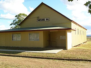
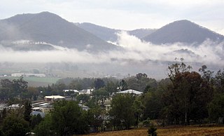
Tannymorel is a rural town and locality in the Southern Downs Region, Queensland, Australia. In the 2016 census, the locality of Tannymorel had a population of 161 people.

Mount Marshall, Queensland Suburb of Southern Downs Region, Queensland, Australia

Mount Marshall is a rural locality in the Southern Downs Region, Queensland, Australia. In the 2016 census, Mount Marshall had a population of 243 people.

Spring Creek, Queensland (Darling Downs) Suburb of Toowoomba Region, Queensland, Australia

Spring Creek is a rural locality split between the Toowoomba Region and the Southern Downs Region, Queensland, Australia. In the 2016 census, Spring Creek had a population of 194 people.

Murrays Bridge is a rural locality in the Southern Downs Region, Queensland, Australia. In the 2016 census Murrays Bridge had a population of 103 people.

Clintonvale, Queensland Suburb of Southern Downs Region, Queensland, Australia

Clintonvale is a rural locality in the Southern Downs Region, Queensland, Australia. In the 2016 census, Clintonvale had a population of 74 people.

Danderoo is a rural locality in the Southern Downs Region, Queensland, Australia. In the 2016 census, Danderoo had a population of 30 people.

Elbow Valley is a rural locality in the Southern Downs Region, Queensland, Australia. In the 2016 census It is on the border of New South Wales. Elbow Valley had a population of 95 people.

Emu Vale, Queensland Town in Queensland, Australia

Emu Vale is a rural town and locality in the Southern Downs Region, Queensland, Australia. In the 2016 census, Emu Vale had a population of 185 people.

Upper Freestone, Queensland Suburb of Southern Downs Region, Queensland, Australia

Upper Freestone is a rural locality in the Southern Downs Region, Queensland, Australia. In the 2016 census, Upper Freestone had a population of 90 people.

Thane, Queensland Town in Queensland, Australia

Thane is a rural town and locality in the Southern Downs Region, Queensland, Australia. In the 2016 census, Thane had a population of 27 people.

The Falls is a rural locality in the Southern Downs Region, Queensland, Australia. In the 2016 census The Falls had a population of 70 people.

Junabee Suburb of Southern Downs Region, Queensland, Australia

Junabee is a rural locality in the Southern Downs Region, Queensland, Australia. In the 2016 census, Junabee had a population of 213 people.

Mount Tabor is a rural locality in the Southern Downs Region, Queensland, Australia. In the 2016 census, Mount Tabor had a population of 76 people.

References

  1. 1 2 3 Australian Bureau of Statistics (27 June 2017). "Loch Lomond (SSC)". 2016 Census QuickStats. Retrieved 20 October 2018. OOjs UI icon edit-ltr-progressive.svg
  2. 1 2 "Loch Lomond – locality in Southern Downs Region (entry 45948)". Queensland Place Names. Queensland Government . Retrieved 29 December 2020.
  3. Queensland Family History Society (2010), Queensland schools past and present (Version 1.01 ed.), Queensland Family History Society, ISBN   978-1-921171-26-0
  4. "Parish of Cunningham" (Map). Queensland Government. 1949. Archived from the original on 11 September 2021. Retrieved 25 March 2022.
  5. 1 2 3 "Queensland Globe". State of Queensland . Retrieved 27 March 2022.
  6. "Religions[?] Notes". Warwick Examiner And Times . Vol. 39, no. 4967. Queensland, Australia. 12 August 1905. p. 5. Archived from the original on 27 March 2022. Retrieved 27 March 2022 via National Library of Australia.
  7. "THE DROUGHT BREAKS". Warwick Examiner And Times . No. 4803. Queensland, Australia. 18 December 1915. p. 5. Archived from the original on 11 September 2021. Retrieved 10 September 2021 via National Library of Australia.
  8. "9341-31 Loch Lomond" (Map). Queensland Government. 1983. Archived from the original on 27 March 2022. Retrieved 25 March 2022.