
Rathdowney is a rural town and locality in the Scenic Rim Region, Queensland, Australia. In the 2021 census, the locality of Rathdowney had a population of 320 people.

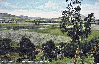
Warwick is a rural town and locality in southeast Queensland, Australia, lying 130 kilometres (81 mi) south-west of Brisbane. It is the administrative centre of the Southern Downs Region local government area. The surrounding Darling Downs have fostered a strong agricultural industry for which Warwick, together with the larger city of Toowoomba, serve as convenient service centres. In the 2021 census, the locality of Warwick had a population of 12,294 people.

Clifton is a rural town and locality in the Toowoomba Region, Queensland, Australia. In the 2021 census, the locality of Clifton had a population of 1,490 people.

Howard is a rural town and locality in the Fraser Coast Region, Queensland, Australia. It is a southern boundary of the Dundaburra peoples of the Northern Kabi Kabi Isis districts and surrounds. It is located 284 kilometres (176 mi) north of Brisbane and 37 kilometres (23 mi) west of Hervey Bay. In the 2021 census, the locality of Howard had a population of 1,394 people.

Booval is a suburb of Ipswich in the City of Ipswich, Queensland, Australia. In the 2021 census, Booval had a population of 2,723 people.

Dinmore is a suburb of Ipswich in the City of Ipswich, Queensland, Australia. In the 2016 census, Dinmore had a population of 875 people with an unemployment rate of 16.7%, in comparison to the Australian unemployment rate of 6.9%.
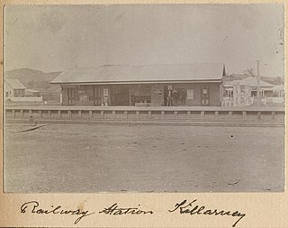
The Killarney railway line was a branch railway in the Darling Downs region of Queensland, Australia. It travelled from Warwick to Killarney and operated from 1884 to 1964.

Maryvale is a rural town and locality in the Southern Downs Region, Queensland, Australia. In the 2021 census, the locality of Maryvale had a population of 392 people.

Maroon is a rural locality in the Scenic Rim Region, Queensland, Australia. In the 2021 census, Maroon had a population of 152 people.

Dalveen is a town and a locality in the Southern Downs Region, Queensland, Australia. It borders New South Wales. In the 2021 census, the locality of Dalveen had a population of 369 people.

Glengallan is a rural locality in the Southern Downs Region, Queensland, Australia. In the 2021 census, Glengallan had a population of 57 people.
Swan Creek is a rural locality in the Southern Downs Region, Queensland, Australia. In the 2021 census, Swan Creek had a population of 161 people.

Yangan is a rural town and locality in the Southern Downs Region, Queensland, Australia. In the 2021 census, the locality of Yangan had a population of 404 people.

Mount Forbes is a rural locality split between the City of Ipswich and the Scenic Rim Region, Queensland, Australia. In the 2021 census, Mount Forbes had a population of 262 people.

Mount Alford is a rural town and locality in the Scenic Rim Region, Queensland, Australia. In the 2021 census, the locality of Mount Alford had a population of 294 people.
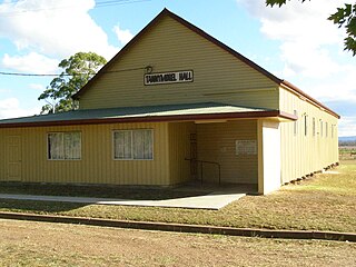
Tannymorel is a rural town and locality in the Southern Downs Region, Queensland, Australia. In the 2021 census, the locality of Tannymorel had a population of 148 people.
Freestone is a rural town and locality in the Southern Downs Region, Queensland, Australia. In the 2021 census, the locality of Freestone had a population of 208 people.

Emu Vale is a rural town and locality in the Southern Downs Region, Queensland, Australia. In the 2021 census, the locality of Emu Vale had a population of 161 people.

Junabee is a rural locality in the Southern Downs Region, Queensland, Australia. In the 2021 census, Junabee had a population of 195 people.
Loch Lomond is a rural locality in the Southern Downs Region, Queensland, Australia. In the 2021 census, Loch Lomond had a population of 119 people.

