Cottonvale, Queensland

Last updated

Cottonvale
Queensland
Community Hall, Cottonvale, Queensland, April 2009.jpg
Community Hall, 2009
Australia Queensland location map.svg
Red pog.svg
Cottonvale
Coordinates 28°31′07″S151°56′21″E / 28.5186°S 151.9391°E / -28.5186; 151.9391 (Cottonvale (centre of locality))
Population153 (SAL 2021) [1]
Postcode(s) 4375
Area11.0 km2 (4.2 sq mi)
Time zone AEST (UTC+10:00)
Location
LGA(s) Southern Downs Region
State electorate(s) Southern Downs
Federal division(s) Maranoa
Suburbs around Cottonvale:
Dalveen Dalveen Dalveen
Fleurbaix Cottonvale Cottonvale (NSW)
Thulimbah Thulimbah Cottonvale (NSW)

Cottonvale is a rural locality in the Southern Downs Region, Queensland, Australia. [2] It borders New South Wales and contains the town of Cotton Vale. [3] [4] In the 2021 census, Cottonvale had a population of 153 people. [5]

Contents

Geography

The South Western railway line enters the locality from the north-east (Dalveen) and exits to the south (Thulimbah). [4] The town of Cotton Vale is in the east of the locality ( 28°31′06″S151°56′53″E / 28.5184°S 151.9480°E / -28.5184; 151.9480 (Cotton Vale, Queensland) ) beside the now-abandoned Cotton Vale railway station ( 28°31′17″S151°56′56″E / 28.5214°S 151.9490°E / -28.5214; 151.9490 (Cotton Vale railway station) ). [3] [6] [7] [4]

The New England Highway also traverses the locality from the north-east (Dalveen) to the south-east (Thulimbah), always remaining east of the railway line and bypassing the town. [4]

History

After World War I, the area was opened up as a soldier settlement focused on fruit growing. The town was named after the Cotton Vale railway station, which was in turn named in 1920 by the Queensland Railways Department after orchardist Edward Cotton, who was believed to be the first from his district to enlist as a soldier in World War I. [3] [6]

Cottonvale Provisional School opened in the Cottonvale School of Arts Hall on 30 January 1958. On 28 May 1959 it became Cottonvale State School. It was mothballed on 31 December 2004 and closed on 24 August 2005. [8] [9] It was at 11 Cottonvale School Road ( 28°30′58″S151°56′52″E / 28.5162°S 151.9477°E / -28.5162; 151.9477 (Cottonvale State School (former)) ). [10] [11] [4]

Demographics

In the 2016 census, Cottonvale had a population of 148 people. [12]

In the 2021 census, Cottonvale had a population of 153 people. [5]

Education

There are no schools in Cottonvale. The nearest primary schools are Thulimbah State School in neighbouring Thulimbah to the south and Dalveen State School in neighbouring Dalveen to the north. The nearest government secondary school is Stanthorpe State High School in Stanthorpe to the south. [4]

Related Research Articles

<span class="mw-page-title-main">Stanthorpe, Queensland</span> Town in Queensland, Australia

Stanthorpe is a rural town and locality in the Southern Downs Region, Queensland, Australia. In the 2016 census, Stanthorpe had a population of 5,406 people.

<span class="mw-page-title-main">Wallangarra, Queensland</span> Town in Queensland, Australia

Wallangarra is a rural town and locality in the Southern Downs Region, Queensland, Australia on the border with New South Wales. In the 2016 census, the locality of Wallangarra had a population of 468 people.

<span class="mw-page-title-main">Southern Downs Region</span> Local government area in Queensland, Australia

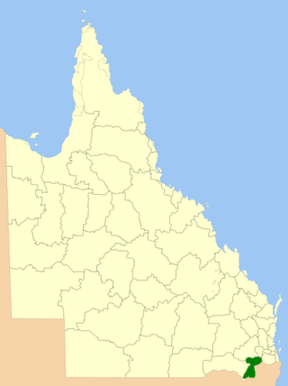
The Southern Downs Region is a local government area in the Darling Downs region of Queensland, Australia, along the state's boundary with New South Wales. It was created in 2008 from a merger of the Shire of Warwick and the Shire of Stanthorpe.

<span class="mw-page-title-main">Applethorpe, Queensland</span> Town in Queensland, Australia

Applethorpe is a rural town and locality in the Southern Downs Region, Queensland, Australia. It is on Queensland's border with New South Wales. It is well known for the production of apples. It often records the lowest temperatures in Queensland.

<span class="mw-page-title-main">Amiens, Queensland</span> Town in Queensland, Australia

Amiens is a rural locality in the Southern Downs Region, Queensland, Australia. In the 2016 census, Amiens had a population of 293 people.

<span class="mw-page-title-main">Ballandean, Queensland</span> Town in Queensland, Australia

Ballandean is a rural town and locality in the Southern Downs Region, Queensland, Australia. In the 2016 census, the locality of Ballandean had a population of 338 people.

<span class="mw-page-title-main">Dalveen, Queensland</span> Town in Queensland, Australia

Dalveen is a town and a locality in the Southern Downs Region, Queensland, Australia. It borders New South Wales. In the 2016 census, Dalveen had a population of 335 people.

<span class="mw-page-title-main">Allan, Queensland</span> Suburb of Southern Downs Region, Queensland, Australia

Allan is a rural locality in the Southern Downs Region, Queensland, Australia. It was formerly known as Sandy Creek. In the 2016 census, Allan had a population of 87 people.

<span class="mw-page-title-main">The Summit railway station</span> Former railway station in Queensland, Australia

The Summit railway station is located on the Southern line in Queensland, Australia. It services the town of The Summit, a fruit growing district in the Granite Belt. At 923.5 metres (3,030 ft) above sea level, it is the highest station in the state.

<span class="mw-page-title-main">Somme, Queensland</span> Suburb of Southern Downs Region, Queensland, Australia

Somme is a rural locality in the Southern Downs Region, Queensland, Australia. In the 2016 census Somme had a population of 53 people.

<span class="mw-page-title-main">The Summit, Queensland</span> Town in Queensland, Australia

The Summit is a rural town and locality in the Southern Downs Region, Queensland, Australia. In the 2016 census, the locality of The Summit had a population of 409 people.

<span class="mw-page-title-main">Lyra, Queensland</span> Suburb of Southern Downs Region, Queensland, Australia

Lyra is a rural locality in the Southern Downs Region, Queensland, Australia. In the 2016 census, Lyra had a population of 53 people.

<span class="mw-page-title-main">Severnlea, Queensland</span> Suburb of Southern Downs Region, Queensland, Australia

Severnlea is a locality in the Southern Downs Region, Queensland, Australia. In the 2016 census, Severnlea had a population of 350 people.

Glen Aplin is a rural locality in the Southern Downs Region, Queensland, Australia. In the 2016 census, Glen Aplin had a population of 503 people.

Dalcouth is a locality in the Southern Downs Region, Queensland, Australia. It is on the border with New South Wales. In the 2016 census, Dalcouth had a population of 165 people.

Elbow Valley is a rural locality in the Southern Downs Region, Queensland, Australia. It is on the border of New South Wales. In the 2016 census, Elbow Valley had a population of 95 people.

<span class="mw-page-title-main">Cherry Gully, Queensland</span> Suburb of Southern Downs Region, Queensland, Australia

Cherry Gully is a locality in the Southern Downs Region, Queensland, Australia. In the 2021 census, Cherry Gully had a population of 18 people.

Fletcher is a rural locality in the Southern Downs Region, Queensland, Australia. In the 2016 census, Fletcher had a population of 92 people.

<span class="mw-page-title-main">Silverwood, Queensland</span> Suburb of Southern Downs Region, Queensland, Australia

Silverwood is a rural locality in the Southern Downs Region, Queensland, Australia. In the 2016 census, Silverwood had a population of 38 people.

Passchendaele is a rural locality in the Southern Downs Region, Queensland, Australia. In the 2016 census, Passchendaele had a population of 30 people.

References

  1. Australian Bureau of Statistics (28 June 2022). "Cottonvale (Qld) (Suburb and Locality)". Australian Census 2021 QuickStats. Retrieved 28 June 2022.  OOjs UI icon edit-ltr-progressive.svg
  2. "Cottonvale – locality in Southern Downs Region (entry 45916)". Queensland Place Names. Queensland Government . Retrieved 6 May 2019.
  3. 1 2 3 "Cotton Vale – population centre in the Southern Downs Region (entry 8549)". Queensland Place Names. Queensland Government . Retrieved 6 May 2019.
  4. 1 2 3 4 5 6 "Queensland Globe". State of Queensland . Retrieved 1 September 2023.
  5. 1 2 Australian Bureau of Statistics (28 June 2022). "Cottonvale (SAL)". 2021 Census QuickStats. Retrieved 28 February 2023. OOjs UI icon edit-ltr-progressive.svg
  6. 1 2 "Cotton Vale – railway station in the Southern Downs Region (entry 39247)". Queensland Place Names. Queensland Government . Retrieved 6 May 2019.
  7. "Railway stations and sidings - Queensland". Queensland Open Data. Queensland Government. 2 October 2020. Archived from the original on 5 October 2020. Retrieved 5 October 2020.
  8. "Queensland state school - centre closures" (PDF). Queensland Government . 20 August 2013. Archived (PDF) from the original on 20 March 2022. Retrieved 6 April 2022.
  9. Queensland Family History Society (2010), Queensland schools past and present (Version 1.01 ed.), Queensland Family History Society, ISBN   978-1-921171-26-0
  10. "9240-11 The Summit" (Map). Queensland Government. 2000. Archived from the original on 22 April 2022. Retrieved 22 April 2022.
  11. Google (22 April 2022). "Cottonvale State School (former)" (Map). Google Maps . Google. Retrieved 22 April 2022.
  12. Australian Bureau of Statistics (27 June 2017). "Cottonvale (SSC)". 2016 Census QuickStats. Retrieved 20 October 2018. OOjs UI icon edit-ltr-progressive.svg

Further reading