Granite Belt

Last updated

Granite Belt
Queensland
Stanthorpe Queensland.jpg
The town of Stanthorpe
LGA(s) Southern Downs Region
State electorate(s) Southern Downs
Federal division(s) Maranoa

The Granite Belt is an area of the Great Dividing Range in the Darling Downs region of Queensland and the New England region of New South Wales, Australia. The Granite Belt is centred on the town of Stanthorpe. The cool, high country of the granite belt is located on Queensland's southern border. It is the northernmost part of the New England Tablelands. [1]

Contents

The area gains its name from the predominantly granite rocks that distinguish it from other areas that make up much of South East Queensland. The Granite Belt is known for its spectacular flowers, and produces virtually all of Queensland's $40 million apple crop from one million trees grown by 55 orchardists. [2]

The area also lies within the Southern Downs region. Including the town of Warwick, the region has a population of 32,600 people. [3] The major river in the region is the Condamine River, a tributary of the Murray River. [3]

Climate

The Granite Belt has a subtropical highland climate that shares similarities to a typical oceanic climate. Under the Köppen climate classification system this would be called a Cfb climate. It is distinguished by its elevation, which makes it the coldest part of Queensland. [4] Being amongst the highest altitude viticultural regions in Australia, it is an ideal climate for grapes, apples, stone fruit and many other fruits and vegetables with the exception of a tendency for hail. Winter months can be very cold on the Granite Belt, and night-time frost is very common. Bleak, overcast conditions on rare occasions bring hail, sleet, and snow. The area has received significant snowfalls in 1984, 2007 and 2015. [5] Situated at between 680 m (2,230 ft) to over 1,200 m (3,900 ft) above sea level, the altitude is the main controlling factor for the climate. [3] The elevation creates a climate of four distinct seasons on the Granite Belt.[ citation needed ]

The area is a popular tourist destination, particularly for the short-break drive market from South East Queensland and northern New South Wales. The boom in wine tourism has been a key driver, and while winter is popular, the region benefits from being a cool contrast to coastal humidity in the summer. Despite spring frosts and variable soils Granite Belt grapes and wines are considered high quality. [1]

Soils

Pink lady apples, Thulimba, 2015 Pink lady apples, Thulimbah, Granite Belt, Queensland, 2015 02.jpg
Pink lady apples, Thulimba, 2015

The regions soils are derived from the parent rocks of Ruby Creek Granite and Stanthorpe Adamellite that form the northern section of the New England Batholith. They are typically sandy loam to clay loam surface soils with clay or parent rock at depth.

Towns

The town of Dalveen is in the north of the Granite Belt. Other villages include Applethorpe, Amiens, Ballandean, Glen Aplin, Passchendaele, Thulimbah, Pozieres, and Wallangarra, in the south at the border with New South Wales. Liston is a small village in New South Wales that is considered part of the Granite Belt.

Attractions

Stanthorpe and the surrounding Granite Belt and Granite Highlands area of South East Queensland and Northern New South Wales are the centre of a booming winery and national parks tourist destination. There are more than 50 wineries in the Granite Belt area. The Granite Belt national parks are Girraween, Bald Rock, Sundown, and Boonoo Boonoo. The region operates its own wine and tourism marketing body named Granite Belt Wine Country.

There is a wide range of restaurants, accommodation places and other tourist venues. Backpacking is popular and there is large demand for fruit and vegetable pickers from November until May each year. [6]

A granite outcrop in Girraween National Park. Vistagirrahween email.jpg
A granite outcrop in Girraween National Park.

The area is Queensland's premier wine region and home to the Queensland College of Wine Tourism. Many of the fifty-plus wineries in the region have enjoyed significant success with Shiraz, Cabernet Sauvignon, Merlot and Chardonnay for some years. Recently Verdelho has performed very well and many wineries are experimenting with alternative grape varieties, including Nebbiolo, Sangiovese and Petit verdot.

The massive Bald Rock in Bald Rock National Park. Baldrockvista1 email.jpg
The massive Bald Rock in Bald Rock National Park.

Part of the Granite Belt is reserved as Girraween National Park, which features granite outcroppings such as the Pyramids, and an abundance of fauna and flora. 'Girraween' can be translated as "place of flowers" in the Aboriginal language from which it is taken. The latter are particularly in evidence in spring, when wildflowers explode into evidence. The area is home to at least 800 species of flowering plants. [7] The botanical group known as the Stanthorpe Rare Flower Consortium has been established as a result of the region's significant floral heritage. Some of these plants include ground orchids, rock roses, pea-flowers and native bluebells. [8]

Further east towards the coast is the Bald Rock National Park and Boonoo Boonoo National Park. Towards the west of the district is the Sundown National Park. The granite boulders of the region attract rock-climbers, and bush-walkers like to explore the little-known Underground River.[ citation needed ]

The possibility of experiencing snow on the ground in Queensland is another tourist attraction for the region. [9]

History

Heritage museum at Ballandean Homestead, 2015 Shepherd's hut from Ballandean station, 2015.JPG
Heritage museum at Ballandean Homestead, 2015

The district was first inhabited by the Githabul peoples. These Indigenous people groups inhabited the land for ten's of thousands of years prior to European exploration and settlement. European settlement began when the land was first explored by Allan Cunningham in 1827. Cunninghams Gap and the Cunningham Highway were named after him.

A number of large pastoral stations were established in the region: [10]

During the following decade, mining of gold, copper and tin brought permanent European settlement to the district.

In 1881, the railway to Warwick was extended to Stanthorpe and then to the border in 1887, when Wallangarra was established. [11]

The countryside around the Granite Belt, after World War I, was given to some returning soldiers as gifts or payment for their services in the war. As such, many of the rural districts are named after battles that took place in France, such as Amiens and Pozieres. These places were, at one point, rather busy and well-populated, but as Stanthorpe grew and returned soldiers grew frustrated with farming, the districts eventually died as many families left. In some places, where there were once Blue Nurse outposts and many stores, all that remain are small primary schools, while in other districts the post-war past remains only in the name.

The region's first wine grapes were planted in 1965. [1]

See also

Related Research Articles

<span class="mw-page-title-main">Bald Rock National Park</span> Protected area in New South Wales, Australia

Bald Rock National Park is a national park in northern New South Wales, Australia, just north of Tenterfield on the Queensland border. The border passes over the rock on the Western side. On the other side of the border national park continues as the Girraween National Park.

<span class="mw-page-title-main">Girraween National Park</span> Protected area in Queensland, Australia

Girraween National Park is an area of the Granite Belt in the Darling Downs region of Queensland, Australia reserved as a national park. Girraween is known for its spectacular flowers, dramatic landscapes and unique wildlife. Bushwalking and rock climbing are the most popular activities in the park.

<span class="mw-page-title-main">Stanthorpe, Queensland</span> Town in Queensland, Australia

Stanthorpe is a rural town and locality in the Southern Downs Region, Queensland, Australia. In the 2021 census, the locality of Stanthorpe had a population of 5,286 people.

<span class="mw-page-title-main">Darling Downs</span> Region in Queensland, Australia

The Darling Downs is a farming region on the western slopes of the Great Dividing Range in southern Queensland, Australia. The Downs are to the west of South East Queensland and are one of the major regions of Queensland. The name was generally applied to an area approximating to that of the Condamine River catchment upstream of Condamine township but is now applied to a wider region comprising the Southern Downs, Western Downs, Toowoomba and Goondiwindi local authority areas. The name Darling Downs was given in 1827 by Allan Cunningham, the first European explorer to reach the area and recognises the then Governor of New South Wales, Ralph Darling.

Liston is a small mountain village in northern New South Wales, Australia in Tenterfield Shire local government area. It lies just inside the eastern boundary of the New South Wales, Queensland border on the old Cobb & Co route, now the Mount Lindesay Highway, which used to extend from Brisbane to Tenterfield, New South Wales.

<span class="mw-page-title-main">Australian wine</span> Wine making in Australia

The Australian wine industry is one of the world's largest exporters of wine, with approximately 800 million out of the 1.2 to 1.3 billion litres produced annually exported to overseas markets. The wine industry is a significant contributor to the Australian economy through production, employment, export, and tourism.

<span class="mw-page-title-main">Shire of Stanthorpe</span> Local government area in Queensland, Australia

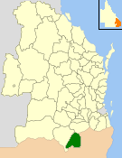
The Shire of Stanthorpe was a local government area of Queensland, Australia on the Queensland-New South Wales border. It was on the Great Dividing Range and was part of the Granite Belt. Its main industries included fruit and vegetable growing, wineries and tourism, and sheep and cattle grazing.

<span class="mw-page-title-main">New South Wales wine</span> Wine produced in New South Wales, Australia

New South Wales wine is Australian wine produced in New South Wales, Australia. New South Wales is Australia's most populous state and its wine consumption far outpaces the region's wine production. The Hunter Valley, located 130 km (81 mi) north of Sydney, is the most well-known wine region but the majority of the state's production takes place in the Big Rivers zone-Perricoota, Riverina and along the Darling and Murray Rivers. The wines produced from the Big Rivers zone are largely used in box wine and mass-produced wine brands such as Yellow Tail. A large variety of grapes are grown in New South Wales, including Cabernet Sauvignon, Chardonnay, Shiraz and Sémillon.

<span class="mw-page-title-main">Amiens railway line</span> Branch railway line in the Granite Belt region of Queensland, Australia

The Amiens railway line was a branch railway in the Granite Belt region of Queensland, Australia, branching from the Southern Line at Cottonvale between Warwick and Stanthorpe. The Amiens line was the highest in southern Queensland, with the railway reaching an elevation of 946 metres above sea level at Pozieres.

<span class="mw-page-title-main">Ballandean Pyramid</span> Stone pyramid near Ballandean, Queensland, Australia

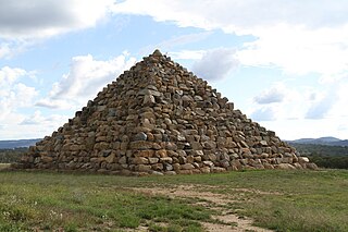
The Ballandean Pyramid is a man-made stone pyramid near the small village of Ballandean, Queensland, Australia. The pyramid is approximately 15 metres in height and built from blocks of the local granite. It is on private property belonging to a local vineyard and is approximately 25 metres from the nearest road.

<span class="mw-page-title-main">Ballandean, Queensland</span> Town in Queensland, Australia

Ballandean is a rural town and locality in the Southern Downs Region, Queensland, Australia. In the 2021 census, the locality of Ballandean had a population of 316 people.

<span class="mw-page-title-main">Ballandean Division</span>

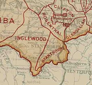
The Ballandean Division was a local government area on the Granite Belt, Queensland, Australia, close to the Queensland-New South Wales border. It only existed between 1879 and 1880.

<span class="mw-page-title-main">Lyra, Queensland</span> Suburb of Southern Downs Region, Queensland, Australia

Lyra is a rural locality in the Southern Downs Region, Queensland, Australia. In the 2016 census, Lyra had a population of 53 people.

<span class="mw-page-title-main">Ballandean railway station</span> Former railway station in Queensland, Australia

Ballandean railway station is located on the Southern line in Queensland, Australia. It services the town of Ballandean, a rural district in the Granite Belt.

<span class="mw-page-title-main">Eukey</span> Suburb of Southern Downs Region, Queensland, Australia

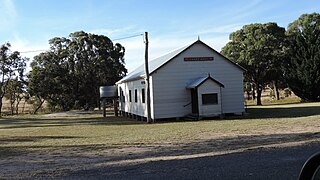
Eukey is a rural locality in the Southern Downs Region, Queensland, Australia. It is on the border with New South Wales. In the 2016 census Eukey had a population of 134 people.

The Apple & Grape Harvest Festival is a biennial festival held in Stanthorpe, Queensland, Australia, taking place over 10 days at the beginning of March. It is one of Queensland's longest-running festivals, first held in 1966 as a celebration of the Granite Belt region’s wine and produce industry.

Angelo Puglisi is an Australian winemaker, best known for owning and managing the Ballandean Estate on Queensland's Granite Belt with his family.

Fletcher is a rural locality in the Southern Downs Region, Queensland, Australia. In the 2016 census, Fletcher had a population of 92 people.

<span class="mw-page-title-main">Girraween, Queensland</span> Suburb of Southern Downs Region, Queensland, Australia

Girraween is an undeveloped locality in the Southern Downs Region, Queensland, Australia. It is in the Granite Belt and on the border with New South Wales. In the 2021 census, Girraween had a population of 5 people.

Nundubbermere is a rural locality in the Southern Downs Region, Queensland, Australia. In the 2021 census, Nundubbermere had a population of 102 people.

References

  1. 1 2 3 Halliday, James (2006). Wine Atlas of Australia. University of California Press. p. 293. ISBN   0520250311. Archived from the original on 5 February 2023. Retrieved 12 July 2015.
  2. Morley, Peter (11 February 2008). "Weather gives apple growers rosy outlook" (News article). The Courier-Mail . Archived from the original on 12 February 2008. Retrieved 12 February 2008.
  3. 1 2 3 "Southern Downs Regional Council". Archived from the original on 21 July 2015. Retrieved 31 January 2008.
  4. "Snow possible for parts of Queensland as brutally cold weather descends on state". ABC News. Australian Broadcasting Corporation. 10 July 2015. Archived from the original on 11 July 2015. Retrieved 10 July 2015.
  5. Kim Stephens (17 July 2015). "Queensland snow: Stanthorpe gets highest falls in a decade". The Brisbane Times. Fairfax Media. Archived from the original on 18 July 2015. Retrieved 17 July 2015.
  6. "BEST Employment Harvest Labour". Best Employment Ltd. Archived from the original on 14 January 2014. Retrieved 28 December 2013.
  7. Hammond, Phil (18 July 2008). "Queensland proves its petal in wildflower stakes". The Courier-Mail . Retrieved 12 August 2008.
  8. Hema Maps (1997). Discover Australia's National Parks. Milsons Point, New South Wales: Random House Australia. p. 172. ISBN   1-875992-47-2.
  9. Stone, Lucy (9 June 2021). "Here's why snow chasers leave Brisbane out in the cold". ABC News. Archived from the original on 1 June 2022. Retrieved 5 February 2023.
  10. "First Pastoral Leases". Stanthorpe Chamber of Commerce. Archived from the original on 5 February 2023. Retrieved 9 June 2015.
  11. Queensland Environmental Protection Agency (2000). Heritage Trails of the Great South East. Queensland Environmental Protection Agency. pp. 116–117. ISBN   978-0-7345-1008-2.

28°39′20″S151°55′57″E / 28.65556°S 151.93250°E / -28.65556; 151.93250