Goombungee, Queensland

Last updated

Goombungee
Queensland
Kingsthorpe Haden Road Goombungee.jpg
Blooming Jacaranda trees on Kingsthorpe Haden Road, 2014
Australia Queensland location map.svg
Red pog.svg
Goombungee
Coordinates 27°18′17″S151°51′07″E / 27.3047°S 151.8519°E / -27.3047; 151.8519 (Goombungee (town centre))
Population1,026 (2016 census) [1]
 • Density13.429/km2 (34.78/sq mi)
Postcode(s) 4354
Area76.4 km2 (29.5 sq mi)
Time zone AEST (UTC+10:00)
LGA(s) Toowoomba Region
Region Darling Downs
County Aubigny
Parish Goombungee
State electorate(s) Condamine
Federal division(s) Groom
Localities around Goombungee:
Kilbirnie Haden Bergen
Highland Plains Goombungee Douglas
Silverleigh Boodua Muniganeen

Goombungee is a rural town and locality in the Toowoomba Region, Queensland, Australia. [2] [3] In the 2016 census the locality of Goombungee had a population of 1,026 people. [1]

Contents

Geography

Goombungee is 35 kilometres (22 mi) north-west of Toowoomba in the Darling Downs. [4]

The town is located in the centre of the locality. [5] The main street through the town is the north-south Kingsthorpe Haden Road, which is known with the town as Mocatta Street. [5]

There are three neighbourhoods within Goombungee:

Road infrastructure

The Pechey-Maclagan Road runs through from east to west, and the Kingsthorpe-Haden Road from south to north. [10]

History

Goombungee Co-op Dairy Company, circa 1905 StateLibQld 1 123487 Workers and visitors outside the Goombungee Co-op Dairy Coy, Ltd., Goombungee, Queensland, ca. 1905.jpg
Goombungee Co-op Dairy Company, circa 1905

The name Goombungee derives from the parish, which in turn took its name from a pastoral run name named by pastoralist Charles William Pitts in 1854. It is thought be a corruption of an Aboriginal name for area, either goubunga or gonbunga. [2] [3] [11]

The first meeting of the former local government area of Shire of Rosalie was held on 17 February 1879. [12] The town is now part of the Toowoomba Region local government area. Goombungee Post Office opened by 1895 (a receiving office had been open from 1878, first known as Gomoran). [13]

Local residents requested a school on 31 May 1880, claiming there were 36 school-aged children in the district. Goombungee Provisional School opened on 1 November 1881 in a 24-by-16-foot (7.3 by 4.9 m) weatherboard building with a shingle roof. The first head teacher was Mrs Annie McLeod Rowland. Although only 17 students enrolled in the school's first year, the original building became too small as the student numbers increased. A new larger building was opened on 3 October 1887 when the school became Goombungee State School. A new schoo building was built in 1933. [14] [15]

In October 1890, St Matthew's Lutheran Church opened with 500 people in attendance. [16]

St Colman's Catholic Church, 1903 St Colman's Catholic Church, Goombungee, 1903.jpg
St Colman's Catholic Church, 1903

St Colman's Catholic Church was opened on Sunday 20 April 1902. [17]

In August 1889 the Queensland Government provided 10 acres (4.0 ha) of land for a cemetery. [18] However, the soil proved too difficult to dig a grave, so another 6.2-acre (2.5 ha) cemetery reserve was provided on 17 January 1894. The first burial in the new cemetery was Edith Annie Lloyd, aged 10 months, occurring on 23 July 1894. [19] Although intended as a cemetery for Goombungee, its location resulted in it being used by residents of both Goombungee and Haden and the name Goombungee-Haden Cemetery began to be used in 1925. In 2008 the cemetery's private trustees handed over the responsibility for the cemetery to the Toowoomba Regional Council. [20]

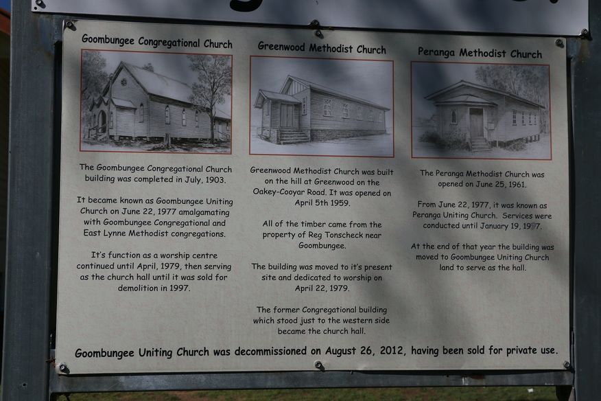
The Goombungee Congregational Church was completed in July 1903. As part of the creation of the Uniting Church in Australia, in 1977 it became the Goombungee Uniting Church in conjunction with the East Lynne (Boodua) Methodist congregation. In 1979, the former Greenwood Methodist Church was relocated to the site immediately east of the Congregational Church building and was officially opened as the new Goombungee Uniting Church on 22 April 1979 with the Congregational Church building becoming the church hall. In late 1999 the former Congregational Church building was demolished and the Peranga Uniting Church relocated to its site to be new church hall. On 26 August 2012 the site (with the Greenwood and Peranga buildings) was decommissioned as a church and subsequently sold into private ownership for $185,000. [21] [22] The church was at 6 George Street ( 27°18′28″S151°51′12″E / 27.3079°S 151.8534°E / -27.3079; 151.8534 (Goombungee Uniting Church (former)) ) and the church buildings are still extant (as at 2020). [23] [5]

On Thursday 30 April 1908, St Mark's Anglican Church was opened by Archdeacon Henry Le Fanu. [24]

In December 1920, the Goombungee War Memorial was unveiled by Sir T W Glasgow. [25] [26]

The Assembly of God church was built by volunteer labour on land donated by Stan and Mavis Kajewski. On 25 August 1956 the church was officially opened by Pastor H E Wiggins of Maryborough. When the Assembly of God amalgamated to form the Australian Christian Churches, the church was renamed Goombungee Christian Church. [27]

Goombungee Wesleyan Methodist Church was established in 1981. [28]

In 2003, the town was connected to a mains water supply. [29]

The Goombungee Library opened in 2005. [30]

At the 2011 census, Goombungee had a population of 1,032. [31]

In the 2016 census, the locality of Goombungee had a population of 1,026 people. [1]

In 2019 the Anglican parish of Crows Nest (which includes Goombungee) entered in a partnership with St David's Anglican Church in Chelmer, Brisbane, to share their ministry through a combination of services at the various churches combined with online services from St David's. It is an experiment in how the Anglican Church may operate in the future. [32]

Heritage listings

Goombungee War Memorial Goombungee War Memorial.jpg
Goombungee War Memorial

Goombungee has a number of heritage-listed sites, including Goombungee War Memorial at the junction of Mocatta Street and Hartwig Street ( 27°18′22″S151°51′06″E / 27.3062°S 151.8516°E / -27.3062; 151.8516 (Goombungee War Memorial) ). [26]

Economy

There are a number of homesteads in the locality, including Gware Hill ( 27°21′08″S151°49′18″E / 27.3523°S 151.8217°E / -27.3523; 151.8217 (Gware Hill (homestead)) ). [33]

Education

Goombungee State School, 2023 Goombungee State School, 2023.jpg
Goombungee State School, 2023

Goombungee State School is a government primary (Prep-6) school for boys and girls at 52 Mocatta Street ( 27°18′07″S151°51′09″E / 27.3020°S 151.8525°E / -27.3020; 151.8525 (Goombungee State School) ). [34] [35] In 2018, the school had an enrolment of 115 students with 9 teachers (8 full-time equivalent) and 7 non-teaching staff (5 full-time equivalent). [36]

There are no secondary schools. The nearest secondary schools are Crows Nest State School (to Year 10) in Crows Nest to the east, Highfields State Secondary College (to Year 12) in Highfields to the south, and Oakey State High School (to Year 12) in Oakey to the south-west. [5]

Facilities

Goombungee police station, 2014 Goombungee police station.jpg
Goombungee police station, 2014

Goombungee Police Station is at 42 Barker Street ( 27°18′24″S151°51′16″E / 27.3067°S 151.8544°E / -27.3067; 151.8544 (Goombungee Police Station) ). [37] [38]

Goombungee Fire Station and Goombungee SES Facility is at 33-35 Cooke Street ( 27°17′50″S151°51′10″E / 27.2972°S 151.8528°E / -27.2972; 151.8528 (Goombungee Fire Station) ). [37]

Goombungee Rural Fire Station is at 4 King Street ( 27°18′21″S151°51′12″E / 27.3057°S 151.8533°E / -27.3057; 151.8533 (Goombungee Rural Fire Station) ). [37] [39]

Goombungee Haden Cemetery, 2006 Goombungee Haden Cemetery, 2006.jpg
Goombungee Haden Cemetery, 2006

The Goombungee Haden cemetery is in Cemetery Road ( 27°14′59″S151°51′47″E / 27.2497°S 151.8630°E / -27.2497; 151.8630 (Goombungee General Cemetery) ), which is now just over the boundary into neighbouring Haden. [20]

Amenities

St Matthew's Lutheran Church, 2014 St Matthew's Lutheran Church Goombungee.jpg
St Matthew's Lutheran Church, 2014

The Goombungee Library is operated by the Toowoomba Regional Council. The library is located at 89 Mocatta Street ( 27°18′13″S151°51′02″E / 27.3035°S 151.8506°E / -27.3035; 151.8506 (Goombungee Public Library) ) and is open three days a week (Tuesday, Thursday and Saturday). [40]

The Goombungee branch of the Queensland Country Women's Association meets at the CWA Rest Rooms at 56 Mocatta Street ( 27°18′20″S151°51′07″E / 27.3055°S 151.8520°E / -27.3055; 151.8520 (Goombungee CWA Rest Rooms) ). [41]

The town is served by a number of churches:

St Colman's Catholic Church, 2014 St. Colmans Church Goombungee.jpg
St Colman's Catholic Church, 2014

The Goombungee Showgrounds are in Lau Street ( 27°18′18″S151°51′30″E / 27.3049°S 151.8582°E / -27.3049; 151.8582 (Goombungee Showgrounds) ). [52]

There are a number of parks in the area:

Goombungee Golf Club has an 18-hole golf course on Golf Course Road ( 27°19′37″S151°50′59″E / 27.3270°S 151.8497°E / -27.3270; 151.8497 (Goombungee Golf Club) ). [58]

Events

Each November, Goombungee hosts a Jacaranda Day festival in the main street, celebrating the history of the town and the blooming jacarandas and silky oaks.

The annual Goombungee-Haden Show is held each autumn at the Showgrounds . The Goombungee Rodeo is also held there on the first Saturday in November. [4] [52]

Attractions

The town boasts a unique ironman at the southern entrance to the town which is reminiscent of the Rural Ironman and Ironwoman competition which was once held annually on Australia Day. [59] There is also a historic museum and an art gallery.

Awards

Goombungee has won four Queensland Tidy Towns awards, in 1975/76, 1976/77, 1980/81 and 1981/82. [60]

Related Research Articles

<span class="mw-page-title-main">Dalby, Queensland</span> Town in Queensland, Australia

Dalby is a rural town and locality in the Western Downs Region, Queensland, Australia. In the 2021 census, the locality of Dalby had a population of 12,082 people.

<span class="mw-page-title-main">Clifton, Queensland</span> Town in Queensland, Australia

Clifton is a rural town and locality in the Toowoomba Region, Queensland, Australia. In the 2016 census, Clifton had a population of 1,456 people.

Glenvale is a semi-rural residential locality in the Toowoomba Region, Queensland, Australia. It is a suburb of Toowoomba. In the 2016 census, Glenvale had a population of 6,353 people.

Peranga is a rural town and locality in the Toowoomba Region, Queensland, Australia. In the 2016 census the locality of Peranga had a population of 85 people.

<span class="mw-page-title-main">Kingsthorpe, Queensland</span> Town in Queensland, Australia

Kingsthorpe is a rural town and locality in the Toowoomba Region, Queensland, Australia. In the 2021 census, the locality of Kingsthorpe had a population of 2,159 people.

Wilsonton Heights is a residential locality of Toowoomba in the Toowoomba Region, Queensland, Australia. In the 2021 census, Wilsonton Heights had a population of 2,747 people.

<span class="mw-page-title-main">Newtown, Queensland (Toowoomba)</span> Suburb of Toowoomba, Queensland, Australia

Newtown is a residential locality in Toowoomba in the Toowoomba Region, Queensland, Australia. In the 2021 census, Newtown had a population of 10,039 people.

<span class="mw-page-title-main">Rangeville, Queensland</span> Suburb of Toowoomba, Queensland, Australia

Rangeville is a residential locality in Toowoomba in the Toowoomba Region, Queensland, Australia. In the 2021 census, Rangeville had a population of 8,668 people.

Haden is a rural town and locality in the Toowoomba Region, Queensland, Australia. In the 2016 census, the locality of Haden had a population of 195 people.

<span class="mw-page-title-main">Mount Tyson, Queensland</span> Town in Queensland, Australia

Mount Tyson is a rural town and locality in the Toowoomba Region, Queensland, Australia. In the 2016 census, the locality of Mount Tyson had a population of 285 people.

<span class="mw-page-title-main">Boodua, Queensland</span> Suburb of Toowoomba Region, Queensland, Australia

Boodua is a rural locality in the Toowoomba Region, Queensland, Australia. In the 2016 census Boodua had a population of 93 people.

<span class="mw-page-title-main">Bergen, Queensland</span> Suburb of Toowoomba Region, Queensland, Australia

Bergen is a rural locality in the Toowoomba Region, Queensland, Australia. In the 2016 census, Bergen had a population of 68 people.

Greenwood is a rural locality in the Toowoomba Region, Queensland, Australia. In the 2016 census, Greenwood had a population of 40 people.

Pinelands is a rural locality in the Toowoomba Region, Queensland, Australia. In the 2016 census, Pinelands had a population of 86 people.

<span class="mw-page-title-main">Douglas, Queensland (Toowoomba Region)</span> Suburb of Toowoomba Region, Queensland, Australia

Douglas is a rural locality in the Toowoomba Region, Queensland, Australia. In the 2016 census, Douglas had a population of 112 people.

Highland Plains is a rural locality in the Toowoomba Region, Queensland, Australia. In the 2021 census, Highland Plains had a population of 60 people.

Cutella is a rural locality in the Toowoomba Region, Queensland, Australia. In the 2021 census, Cutella had a population of 45 people.

Doctor Creek is a rural locality in the Toowoomba Region, Queensland, Australia. In the 2016 census, Doctor Creek had a population of 37 people.

Mount Darry is a rural locality in the Toowoomba Region, Queensland, Australia. In the 2016 census Mount Darry had a population of 35 people.

Glenaven is a rural locality in the Toowoomba Region, Queensland, Australia. In the 2016 census, Glenaven had a population of 79 people.

References

  1. 1 2 3 Australian Bureau of Statistics (27 June 2017). "Goombungee (SSC)". 2016 Census QuickStats. Retrieved 20 October 2018. OOjs UI icon edit-ltr-progressive.svg
  2. 1 2 "Goombungee – town in Toowoomba Region (entry 14265)". Queensland Place Names. Queensland Government . Retrieved 16 December 2020.
  3. 1 2 "Goombungee – locality in Toowoomba Region (entry 47952)". Queensland Place Names. Queensland Government . Retrieved 16 December 2020.
  4. 1 2 "Goombungee". Archived from the original on 7 November 2014. Retrieved 7 November 2014.
  5. 1 2 3 4 "Queensland Globe". State of Queensland . Retrieved 16 December 2020.
  6. 1 2 3 "Jondaryan" (Map). Queensland Government. 1943. Retrieved 2 September 2023.
  7. "Kudo – locality unbounded in Toowoomba Regional (entry 18566)". Queensland Place Names. Queensland Government . Retrieved 16 December 2020.
  8. "Nara – locality unbounded in Toowoomba Regional (entry 23839)". Queensland Place Names. Queensland Government . Retrieved 16 December 2020.
  9. "Weelu – locality unbounded in Toowoomba Regional (entry 39344)". Queensland Place Names. Queensland Government . Retrieved 16 December 2020.
  10. Goombungee, Queensland (Map). OpenStreetMap. Retrieved 28 March 2022.
  11. "Darling Downs: Natural Features and Pastoral Runs 1827 to 1859: ANPS Data Report No 6" (PDF). Australian National Placenames Survey. 2017. p. 14. Archived (PDF) from the original on 16 December 2020.
  12. Jenny Swan and Jess Daly. "Goombungee goes period for 125th anniversary". ABC Southern Queensland . Australian Broadcasting Corporation. Archived from the original on 12 November 2012. Retrieved 27 September 2010.
  13. Phoenix Auctions History. "Post Office List". Phoenix Auctions. Archived from the original on 26 August 2021. Retrieved 22 February 2021.
  14. Queensland Family History Society (2010), Queensland schools past and present (Version 1.01 ed.), Queensland Family History Society, ISBN   978-1-921171-26-0
  15. Ledwidge, Jean (1981), The centenary of Goombungee State School : 1881-1981 : souvenir booklet, Goombungee State School, pp. 7–9, 93 via State Library of Queensland
  16. "German Church at Goombungee". Toowoomba Chronicle and Darling Downs General Advertiser . No. 4427. Queensland, Australia. 9 October 1890. p. 4. Archived from the original on 26 August 2021. Retrieved 18 December 2020 via National Library of Australia.
  17. "Goombungee". Toowoomba Chronicle and Darling Downs General Advertiser . No. 6269. Queensland, Australia. 22 April 1902. p. 3. Archived from the original on 26 August 2021. Retrieved 18 December 2020 via National Library of Australia.
  18. "Official Notifications". The Brisbane Courier . Vol. XLVI, no. 9, 845. Queensland, Australia. 3 August 1889. p. 4. Archived from the original on 26 August 2021. Retrieved 18 December 2020 via National Library of Australia.
  19. "Death registration: Edith Anne Lloyd". Queensland Government . Archived from the original on 17 December 2020. Retrieved 17 December 2020.
  20. 1 2 "Location, open hours and interment options for all Toowoomba Regional Council cemeteries". Toowoomba Regional Council . Archived from the original on 17 December 2020. Retrieved 17 December 2020.
  21. "Noticeboard outside Goombungee Uniting Church, 6 George Street". Churches Australia. Archived from the original on 17 December 2020. Retrieved 17 December 2020.
  22. "6 George Street Goombungee Qld 4354". Realestate.com.au . Retrieved 17 December 2020.
  23. "Goombungee Uniting Church - Former". Churches Australia. Archived from the original on 17 December 2020. Retrieved 17 December 2020.
  24. "Goombungee Anglican Church". Darling Downs Gazette . Vol. L, no. 8, 312. Queensland, Australia. 5 May 1908. p. 5. Archived from the original on 26 August 2021. Retrieved 18 December 2020 via National Library of Australia.
  25. "The Week at a Glance". The Queenslander . 18 December 1920. p. 25. Archived from the original on 16 December 2020. Retrieved 7 November 2014 via National Library of Australia.
  26. 1 2 "Goombungee War Memorial (entry 600826)". Queensland Heritage Register . Queensland Heritage Council. Retrieved 15 July 2013.
  27. "Goombungee Christian Church". Churches Australia. Archived from the original on 17 December 2020. Retrieved 17 December 2020.
  28. "Goombungee Wesleyan Methodist Church". Australian Charities and Not-for-profits Commission . Archived from the original on 17 December 2020. Retrieved 17 December 2020.
  29. "Minister turns on taps for Rosalie Shire residents". ABC News Online . Australian Broadcasting Corporation. 14 November 2003. Archived from the original on 20 February 2011. Retrieved 27 September 2010.
  30. "Public Libraries Statistical Bulletin 2016-17" (PDF). Public Libraries Connect. State Library of Queensland. November 2017. p. 16. Archived (PDF) from the original on 30 January 2018. Retrieved 30 January 2018.
  31. Australian Bureau of Statistics (31 October 2012). "Goombungee (State Suburb)". 2011 Census QuickStats. Retrieved 28 December 2014. OOjs UI icon edit-ltr-progressive.svg
  32. "Anglican Parish of Crows Nest". St David's Anglican Church, Chelmer. Archived from the original on 18 December 2020. Retrieved 18 December 2020.
  33. "Homesteads - Queensland". Queensland Open Data. Queensland Government. 18 November 2020. Archived from the original on 24 November 2020. Retrieved 24 November 2020.
  34. "State and non-state school details". Queensland Government. 9 July 2018. Archived from the original on 21 November 2018. Retrieved 21 November 2018.
  35. "Goombungee State School". Goombungee State School. 9 December 2022. Retrieved 29 September 2023.
  36. "ACARA School Profile 2018". Australian Curriculum, Assessment and Reporting Authority. Archived from the original on 27 August 2020. Retrieved 28 January 2020.
  37. 1 2 3 "Emergency services facilities - Queensland". Queensland Open Data. Queensland Government. 18 November 2020. Archived from the original on 24 November 2020. Retrieved 24 November 2020.
  38. "Goombungee Station". Queensland Police . Archived from the original on 16 December 2020. Retrieved 16 December 2020.
  39. "South Western Region". Queensland Fire and Emergency Services . Archived from the original on 16 December 2020. Retrieved 16 December 2020.
  40. "Toowoomba Regional Council". Archived from the original on 24 October 2014. Retrieved 11 November 2014.
  41. "Branch Locations". Queensland Country Women's Association. Archived from the original on 26 December 2018. Retrieved 26 December 2018.
  42. "Lutheran Church Goombungee St Matthews Congregation, Qld". Goombungee St Matthews Congregation, Qld. Archived from the original on 17 December 2020. Retrieved 17 December 2020.
  43. "St Matthew's Lutheran Church". Churches Australia. Archived from the original on 18 December 2020. Retrieved 18 December 2020.
  44. "St Matthew's Parish, Crows Nest". Roman Catholic Diocese of Toowoomba . Archived from the original on 16 December 2020. Retrieved 16 December 2020.
  45. "St Colman's Catholic Church". Churches Australia. Archived from the original on 26 August 2021. Retrieved 18 December 2020.
  46. "St Mark's Anglican Church". Churches Australia. Archived from the original on 18 December 2020. Retrieved 18 December 2020.
  47. "Goombungee". Wesleyan Methodist Church Australia. Archived from the original on 17 December 2020. Retrieved 17 December 2020.
  48. "Goombungee Wesleyan Methodist Church |". Churches Australia. Archived from the original on 18 December 2020. Retrieved 18 December 2020.
  49. "South Queensland". Wesleyan Methodist Church Australia. Archived from the original on 21 August 2021. Retrieved 25 August 2021.
  50. "Goombungee Christian Church". Goombungee Christian Church. Archived from the original on 17 December 2020. Retrieved 17 December 2020.
  51. "Goombungee Christian Church". Churches Australia. Archived from the original on 17 December 2020. Retrieved 18 December 2020.
  52. 1 2 "Goombungee". Toowoomba Regional Council . Archived from the original on 17 December 2020. Retrieved 17 December 2020.
  53. 1 2 "Land for public recreation - Queensland". Queensland Open Data. Queensland Government. 20 November 2020. Archived from the original on 22 November 2020. Retrieved 22 November 2020.
  54. "Goombungee - Norm Wockner Park". Toowoomba Regional Council . Archived from the original on 17 December 2020. Retrieved 17 December 2020.
  55. "Goombungee - Pioneer Park". Toowoomba Regional Council . Archived from the original on 17 December 2020. Retrieved 17 December 2020.
  56. "Goombungee - Bottle Tree Park". Toowoomba Regional Council . Archived from the original on 17 December 2020. Retrieved 17 December 2020.
  57. "Goombungee - Sports & Recreation Reserve". Toowoomba Regional Council . Archived from the original on 17 December 2020. Retrieved 17 December 2020.
  58. "Contact us". Goombungee Golf Club. Archived from the original on 18 December 2020. Retrieved 18 December 2020.
  59. "Goombungee". queenslandholidays.com.au. Tourism Queensland. Archived from the original on 28 October 2008. Retrieved 27 September 2010.
  60. Winners Gallery - Tidy Towns - Queensland Archived 1 October 2011 at the Wayback Machine . Keep Queensland Beautiful. Retrieved 28 December 2014.

Further reading