Felton South, Queensland

Last updated

Felton South
Queensland
Australia Queensland location map.svg
Red pog.svg
Felton South
Coordinates 27°52′55″S151°43′04″E / 27.8819°S 151.7177°E / -27.8819; 151.7177 (Felton South (centre of locality))
Population78 (SAL 2021) [1]
Postcode(s) 4358
Area68.1 km2 (26.3 sq mi)
Time zone AEST (UTC+10:00)
Location
LGA(s) Toowoomba Region
State electorate(s) Condamine
Federal division(s) Maranoa
Suburbs around Felton South:
North Branch Felton Felton
North Branch Felton South Back Plains
Ellangowan Ellangowan Ellangowan

Felton South is a rural locality in the Toowoomba Region, Queensland, Australia. [2] In the 2021 census, Felton South had a population of 78 people. [3]

Contents

Geography

The locality is bounded to the south-west by the Condamine River and to the north-west by Hodgson Creek. [4]

The Toowoomba Karara Road enters the locality from the north-west (Felton) and exits the locality to the south (Ellangowan). [4]

The land use is predominantly crop growing with some grazing on native vegetation. [4]

History

The locality takes its name from the pastoral run name, which was named by pastoralist Charles Mallard in the early 1840s after his English birthplace. [2]

Felton South State School opened in 1929. [5] On Wednesday 5 March 1947, the school was burned down in a fire. The teacher Miss P. Pulbrook and the 14 students of the school used a cottage provided by Mr P. J. Kelleher as temporary premises. [6] Less than two weeks later, the cottage was also burned down, leading to the belief that the fires were deliberately started. [7] [8] [9] While an official inquiry decided the fires were deliberately lit, no suspects were identified. [10] [11] The school closed circa 1952. [12] It was on the western side of the Toowoomba Karara Road ( 27°52′12″S151°43′23″E / 27.86990°S 151.72310°E / -27.86990; 151.72310 (Felton South State School (former)) ). [13] [14] [4]

Demographics

In the 2016 census, Felton South had a population of 65 people. [15]

In the 2021 census, Felton South had a population of 78 people. [3]

Education

There are no schools in Felton South. The nearest government primary schools are Back Plains State School in neighbouring Back Plains to the east and Pittsworth State School in Pittsworth to the north. The nearest government secondary schools are Pittsworth State High School in Pittsworth and Clifton State High School in Clifton to the east. [4]

Related Research Articles

<span class="mw-page-title-main">Nobby, Queensland</span> Town in Queensland, Australia

Nobby is a rural town and locality on the Darling Downs in the Toowoomba Region, Queensland, Australia. It is located halfway between Toowoomba and Warwick. It is known for its association with Steele Rudd (author) and Sister Elizabeth Kenny.

<span class="mw-page-title-main">Clifton, Queensland</span> Town in Queensland, Australia

Clifton is a rural town and locality in the Toowoomba Region, Queensland, Australia. In the 2016 census, Clifton had a population of 1,456 people.

<span class="mw-page-title-main">Pittsworth, Queensland</span> Town in Queensland, Australia

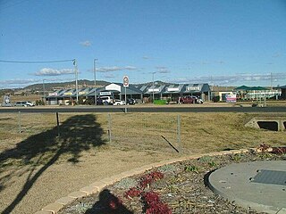
Pittsworth is a rural town and locality in the Toowoomba Region, Queensland, Australia. In the 2016 census, the locality of Pittsworth had a population of 3,294 people.

<span class="mw-page-title-main">Millmerran, Queensland</span> Town in Queensland, Australia

Millmerran, known as Domville between 1 June 1889 and 16 November 1894, is a town and a locality in the Toowoomba Region, Queensland, Australia. In the 2016 census, the locality of Millmerran had a population of 1,563 people.

<span class="mw-page-title-main">Leyburn, Queensland</span> Town in Queensland, Australia

Leyburn is a rural town in the Southern Downs Region and a locality split between the South Downs Region and the Toowoomba Region in Queensland, Australia. In the 2016 census, Leyburn had a population of 476 people.

Wyreema is a rural town and locality in the Toowoomba Region, Queensland, Australia. In the 2016 census, the locality of Wyreema had a population of 1,834 people.

<span class="mw-page-title-main">Karara, Queensland</span> Town in Queensland, Australia

Karara is a rural town and locality in the Southern Downs Region, Queensland, Australia. In the 2016 census, the locality of Karara had a population of 123 people.

<span class="mw-page-title-main">Westbrook, Queensland</span> Suburb of Toowoomba Region, Queensland, Australia

Westbrook is a rural town and locality in the Toowoomba Region, Queensland, Australia. In the 2016 census, the locality of Westbrook had a population of 3,885 people.

<span class="mw-page-title-main">Aubigny, Queensland</span> Town in Queensland, Australia

Aubigny is a rural town and locality in the Toowoomba Region, Queensland, Australia. In the 2016 census, the locality of Aubigny had a population of 254 people.

<span class="mw-page-title-main">Pampas, Queensland</span> Suburb of Toowoomba Region, Queensland, Australia

Pampas is a rural locality in the Toowoomba Region, Queensland, Australia. In the 2016 census, Pampas had a population of 62 people.

<span class="mw-page-title-main">Southbrook, Queensland</span> Town in Queensland, Australia

Southbrook is a rural town and locality in the Toowoomba Region, Queensland, Australia. In the 2021 census, the locality of Southbrook had a population of 626 people.

<span class="mw-page-title-main">Felton, Queensland</span> Suburb of Toowoomba Region, Queensland, Australia

Felton is a rural locality in the Toowoomba Region, Queensland, Australia. In the 2016 census, Felton had a population of 276 people.

Captains Mountain is a locality in the Toowoomba Region, Queensland, Australia. In the 2021 census, Captains Mountain had a population of 74 people.

Ellangowan is a rural locality in the Toowoomba Region, Queensland, Australia. In the 2021 census, Ellangowan had a population of 95 people.

<span class="mw-page-title-main">Brookstead, Queensland</span> Town in Queensland, Australia

Brookstead is a rural town and locality in the Toowoomba Region, Queensland, Australia. In the 2016 census, Brookstead had a population of 217 people.

Norwin is a rural locality in the Toowoomba Region, Queensland, Australia. In the 2016 census, Norwin had a population of 94 people.

Rossvale is a rural locality in the Toowoomba Region, Queensland, Australia. In the 2016 census, Rossvale had a population of 75 people.

Yarranlea is a rural locality in the Toowoomba Region, Queensland, Australia. In the 2016 census, Yarranlea had a population of 90 people.

Turallin is a rural town and locality in the Toowoomba Region, Queensland, Australia. In the 2021 census, the locality of Turallin had a population of 64 people.

Toowoomba–Karara Road is a continuous 82.5 kilometres (51.3 mi) road route in the Toowoomba and Southern Downs regions of Queensland, Australia. Most of the route is signed as State Route 48. Toowoomba–Karara Road is a state-controlled district road. As part of State Route 48 it provides an alternate route between Toowoomba and Inglewood. It is also part of the shortest route from Toowoomba to Texas.

References

  1. Australian Bureau of Statistics (28 June 2022). "Felton South (Suburb and Locality)". Australian Census 2021 QuickStats. Retrieved 28 June 2022.  OOjs UI icon edit-ltr-progressive.svg
  2. 1 2 "Felton South – locality in Toowoomba Region (entry 49262)". Queensland Place Names. Queensland Government . Retrieved 11 June 2019.
  3. 1 2 Australian Bureau of Statistics (28 June 2022). "Felton South (SAL)". 2021 Census QuickStats. Retrieved 28 February 2023. OOjs UI icon edit-ltr-progressive.svg
  4. 1 2 3 4 5 "Queensland Globe". State of Queensland . Retrieved 8 September 2023.
  5. "STATE SCHOOLS". The Brisbane Courier . No. 22, 236. Queensland, Australia. 4 May 1929. p. 29. Retrieved 8 September 2023 via National Library of Australia.
  6. "FELTON SOUTH SCHOOL DESTROYED BY FIRE". Pittsworth Sentinel . Vol. 47. Queensland, Australia. 7 March 1947. p. 2. Retrieved 8 September 2023 via National Library of Australia.
  7. "Fire Closes School Twice Within Fortnight". Pittsworth Sentinel . Vol. 47. Queensland, Australia. 18 March 1947. p. 2. Retrieved 8 September 2023 via National Library of Australia.
  8. ""Fires Lit Deliberately"". Pittsworth Sentinel . Vol. 47. Queensland, Australia. 21 March 1947. p. 2. Retrieved 8 September 2023 via National Library of Australia.
  9. "SMALL TOWN'S FIGHT TO KEEP SCHOOL OPERATING". The Courier-mail . No. 3231. Queensland, Australia. 2 April 1947. p. 5. Retrieved 8 September 2023 via National Library of Australia.
  10. ""Mystery" Fire at Felton South". Warwick Daily News . No. 8793. Queensland, Australia. 9 October 1947. p. 4. Retrieved 8 September 2023 via National Library of Australia.
  11. "NEWS ITEMS". Pittsworth Sentinel . Vol. 47. Queensland, Australia. 17 October 1947. p. 2. Retrieved 8 September 2023 via National Library of Australia.
  12. Queensland Family History Society (2010), Queensland schools past and present (Version 1.01 ed.), Queensland Family History Society, ISBN   978-1-921171-26-0
  13. "Clifton" (Map). Queensland Government. 1944. Archived from the original on 6 September 2023. Retrieved 8 September 2023.
  14. "Parish of Tooth" (Map). Queensland Government. 1933. Retrieved 8 September 2023.
  15. Australian Bureau of Statistics (27 June 2017). "Felton South (SSC)". 2016 Census QuickStats. Retrieved 20 October 2018. OOjs UI icon edit-ltr-progressive.svg