Stoneleigh, Queensland

Last updated

Map all coordinates using: OpenStreetMap
Stoneleigh
Queensland
Australia Queensland location map.svg
Red pog.svg
Stoneleigh
Coordinates 27°39′54″S151°37′24″E / 27.665°S 151.6233°E / -27.665; 151.6233 (Stoneleigh (centre of locality))
Population124 (SAL 2021) [1]
Postcode(s) 4356
Area30.3 km2 (11.7 sq mi)
Time zone AEST (UTC+10:00)
Location
LGA(s) Toowoomba Region
State electorate(s) Condamine
Federal division(s) Groom
Suburbs around Stoneleigh:
Rossvale Linthorpe Linthorpe
Rossvale Stoneleigh Linthorpe
Springside Pittsworth Pittsworth

Stoneleigh is a rural locality in the Toowoomba Region, Queensland, Australia. [2] In the 2021 census, Stoneleigh had a population of 124 people. [3]

Contents

Geography

The terrain is hilly ranging from 460 to 670 metres (1,510 to 2,200 ft) with two similarly-named but distinct peaks:

Wyangapinni is a neighbourhood in the north-west of the locality ( 27°38′00″S151°37′00″E / 27.6333°S 151.6166°E / -27.6333; 151.6166 (Wyangapinni) ). It takes its name from Mount Wyangapinni (which is in neighbouring Rossvale to the north-west). [7] [8]

The Gore Highway forms a small part of the south-eastern boundary of the locality. [9]

The McEwan State Forest is in the south-east of the locality. Apart from that protected area, the land use is predominantly agricultural involving both crop growing and grazing. [9]

History

Stoneleigh Provisional School opened in 1906, [10] [11] [12] becoming Stoneleigh State School on 1 January 1909. It closed in 1919. [13]

In July 1935, local farmer Victor George Hawkes of Turallin shot and killed his wife, his two children and his father-in-law before shooting and killing himself. He had started a fire to try to make it appear to be an accident. He had purchased the rifle earlier that day claiming he needed it to shoot wild cats. It was suggested he acted when in unsound mind, noting his depression from financial losses due to the drought and that he had been severely gassed and shellshocked during World War I. [14]

Demographics

In the 2016 census, Stoneleigh had a population of 119 people. [15]

In the 2021 census, Stoneleigh had a population of 124 people. [3]

Education

There are no schools in Stoneleigh, but primary and secondary schools are available in neighbouring Pittsworth. [9]

Related Research Articles

<span class="mw-page-title-main">Bell, Queensland</span> Town in Queensland, Australia

Bell is a rural town and locality in the Western Downs Region, Queensland, Australia. In the 2016 census, the locality of Bell had a population of 502 people.

<span class="mw-page-title-main">Kingsthorpe, Queensland</span> Town in Queensland, Australia

Kingsthorpe is a rural town and locality in the Toowoomba Region, Queensland, Australia. In the 2021 census, the locality of Kingsthorpe had a population of 2,159 people.

<span class="mw-page-title-main">Ballard, Queensland</span> Suburb of Lockyer Valley Region, Queensland, Australia

Ballard is a rural locality in the Lockyer Valley Region, Queensland, Australia. In the 2016 census, Ballard had a population of 151 people.

<span class="mw-page-title-main">Mount Kynoch, Queensland</span> Suburb of Toowoomba, Queensland, Australia

Mount Kynoch is a rural locality in the Toowoomba Region, Queensland, Australia. In the 2016 census, Mount Kynoch had a population of 237 people.

<span class="mw-page-title-main">Ascot, Queensland (Toowoomba Region)</span> Suburb of Toowoomba Region, Queensland, Australia

Ascot is a rural locality in the Toowoomba Region, Queensland, Australia. In the 2016 census, Ascot had a population of 31 people.

<span class="mw-page-title-main">Maclagan, Queensland</span> Town in Queensland, Australia

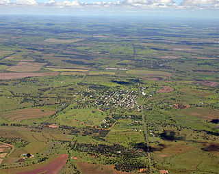
Maclagan is a rural town and locality in the Toowoomba Region, Queensland, Australia. In the 2016 census the locality of Maclagan had a population of 195 people.

<span class="mw-page-title-main">Southbrook, Queensland</span> Town in Queensland, Australia

Southbrook is a rural town and locality in the Toowoomba Region, Queensland, Australia. In the 2021 census, the locality of Southbrook had a population of 626 people.

<span class="mw-page-title-main">Linthorpe, Queensland</span> Suburb of Toowoomba Region, Queensland, Australia

Linthorpe is a rural locality in the Toowoomba Region, Queensland, Australia. In the 2021 census, Linthorpe had a population of 416 people.

<span class="mw-page-title-main">Mount Irving, Queensland</span> Suburb of Toowoomba Region, Queensland, Australia

Mount Irving is a rural locality in the Toowoomba Region, Queensland, Australia. In the 2021 census, Mount Irving had a population of 34 people.

Ramsay is a rural locality in the Toowoomba Region, Queensland, Australia. In the 2016 census Ramsay had a population of 348 people.

Evanslea is a rural locality in the Toowoomba Region, Queensland, Australia. In the 2016 census Evanslea had a population of 41 people.

Mount Emlyn is a rural locality in the Toowoomba Region, Queensland, Australia. In the 2016 census Mount Emlyn had a population of 16 people.

Nangwee is a rural town and locality in the Toowoomba Region, Queensland, Australia. In the 2016 census the locality of Nangwee had a population of 52 people.

<span class="mw-page-title-main">North Branch, Queensland (Toowoomba Region)</span> Suburb of Toowoomba Region, Queensland, Australia

North Branch is a locality in the Toowoomba Region, Queensland, Australia. In the 2021 census, North Branch had a population of 48 people.

Springside is a rural locality in the Toowoomba Region, Queensland, Australia. In the 2021 census, Springside had a population of 102 people.

McDesme is a rural locality in the Shire of Burdekin, Queensland, Australia. In the 2016 census McDesme had a population of 277 people.

Yargullen is a rural locality in the Toowoomba Region, Queensland, Australia. In the 2016 census Yargullen had a population of 25 people.

Irvingdale is a locality split between the Toowoomba Region and the Western Downs Region, both in Queensland, Australia. In the 2021 census, Irvingdale had a population of 163 people.

Cutella is a rural locality in the Toowoomba Region, Queensland, Australia. In the 2021 census, Cutella had a population of 45 people.

Emu Creek is a rural locality in the Toowoomba Region, Queensland, Australia. In the 2021 census, Emu Creek had a population of 113 people.

References

  1. Australian Bureau of Statistics (28 June 2022). "Stoneleigh (Qld) (suburb and locality)". Australian Census 2021 QuickStats. Retrieved 28 June 2022.  OOjs UI icon edit-ltr-progressive.svg
  2. "Stoneleigh – locality in Toowoomba Region (entry 48070)". Queensland Place Names. Queensland Government . Retrieved 6 February 2019.
  3. 1 2 Australian Bureau of Statistics (28 June 2022). "Stoneleigh (SAL)". 2021 Census QuickStats. Retrieved 28 February 2023. OOjs UI icon edit-ltr-progressive.svg
  4. 1 2 "Mountain peaks and capes - Queensland". Queensland Open Data. Queensland Government. 12 November 2020. Archived from the original on 25 November 2020. Retrieved 25 November 2020.
  5. "Parkers – mountain in Toowoomba Region (entry 26091)". Queensland Place Names. Queensland Government . Retrieved 25 November 2020.
  6. "Parkers Hill – mountain in Toowoomba Region (entry 26092)". Queensland Place Names. Queensland Government . Retrieved 25 November 2020.
  7. "Wyangapinni – locality unbounded in Toowoomba Regional (entry 38261)". Queensland Place Names. Queensland Government . Retrieved 2 October 2023.
  8. "Mount Wyangapinni – mountain in the Toowoomba Region (entry 38262)". Queensland Place Names. Queensland Government . Retrieved 16 January 2024.
  9. 1 2 3 "Queensland Globe". State of Queensland . Retrieved 16 January 2024.
  10. "PUBLIC WORKS". The Brisbane Courier . Vol. LXII, no. 15, 051. Queensland, Australia. 9 April 1906. p. 4. Retrieved 17 January 2024 via National Library of Australia.
  11. "Attacked by Chinese Bandits". The Brisbane Courier . Vol. LXIII, no. 15, 1[?]. Queensland, Australia. 22 June 1906. p. 4. Retrieved 17 January 2024 via National Library of Australia.
  12. "THE EDUCATION DEPARTMENT". Darling Downs Gazette . Vol. L, no. 8, 039. Queensland, Australia. 17 June 1907. p. 7. Retrieved 17 January 2024 via National Library of Australia.
  13. Queensland Family History Society (2010), Queensland schools past and present (Version 1.01 ed.), Queensland Family History Society, ISBN   978-1-921171-26-0
  14. "Stoneleigh Tragedy". Daily Mercury . Vol. 69, no. 183. Queensland, Australia. 2 August 1935. p. 7. Retrieved 6 February 2019 via National Library of Australia.
  15. Australian Bureau of Statistics (27 June 2017). "Stoneleigh (SSC)". 2016 Census QuickStats. Retrieved 20 October 2018. OOjs UI icon edit-ltr-progressive.svg