Silverleigh, Queensland

Last updated

Silverleigh
Queensland
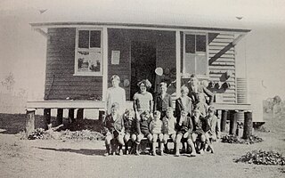
Silverleigh State School jubilee, 1952.jpg
Silverleigh State School jubilee, 1952
Australia Queensland location map.svg
Red pog.svg
Silverleigh
Coordinates 27°20′00″S151°46′51″E / 27.3333°S 151.7808°E / -27.3333; 151.7808 (Silverleigh (centre of locality))
Population80 (2021 census) [1]
 • Density1.72/km2 (4.45/sq mi)
Postcode(s) 4401
Area46.6 km2 (18.0 sq mi)
Time zone AEST (UTC+10:00)
LGA(s) Toowoomba Region
State electorate(s) Condamine
Federal division(s) Groom
Suburbs around Silverleigh:
Acland Highland Plains Highland Plains
Greenwood Silverleigh Goombungee
Greenwood Kelvinhaugh Boodua

Silverleigh is a rural locality in the Toowoomba Region, Queensland, Australia. [2] In the 2021 census, Silverleigh had a population of 80 people. [1]

Contents

Geography

The Oakey–Cooyar Road runs through the north-western corner. [3]

History

A Lutheran congregation formed in 1899 and in November 1890 opened St Paul's Lutheran Church. In 1991, due to differences of opinion on religious issues, the church separated from the Lutheran Church of Australia and, in 1992, joined with a number of other like-minded Lutheran congregations to form the Australian Evangelical Lutheran Church. [4]

Local residents requested a school in 1901. [5] Tenders were called to construct the school in May 1902. [6] Boah Peak Provisional School opened on 8 September 1902 under head teacher Albert Amos Braysher. The school was renamed Silverleigh Provisional School in 1904. On 1 January 1909, it became Silverleigh State School. It closed on 4 June 1967. [7] [8] It was at 836 Acland Silverleigh Road ( 27°19′02″S151°45′44″E / 27.3172°S 151.7622°E / -27.3172; 151.7622 (Silverleigh State School (former)) ). [9] [10]

Demographics

In the 2016 census, Silverleigh had a population of 71 people. [11]

In the 2021 census, Silverleigh had a population of 80 people. [1]

Amenities

Despite the name, St Paul's Lutheran Church, Greenwood, is at 617 Acland Silverleigh Road in Silverleigh ( 27°18′53″S151°44′57″E / 27.31461°S 151.74926°E / -27.31461; 151.74926 (St Paul's Lutheran Church, Greenwood) ). [12]

Related Research Articles

<span class="mw-page-title-main">Kingsthorpe, Queensland</span> Town in Queensland, Australia

Kingsthorpe is a rural town and locality in the Toowoomba Region, Queensland, Australia. In the 2021 census, the locality of Kingsthorpe had a population of 2,159 people.

<span class="mw-page-title-main">Acland, Queensland</span> Town in Queensland, Australia

Acland is a rural town and locality in the Toowoomba Region, Queensland, Australia. In the 2021 census, the locality of Acland had a population of 3 people.
<span class="mw-page-title-main">Goombungee, Queensland</span> Town in Queensland, Australia

Goombungee is a rural town and locality in the Toowoomba Region, Queensland, Australia. In the 2021 census, the locality of Goombungee had a population of 1,066 people.

Haden is a rural town and locality in the Toowoomba Region, Queensland, Australia. In the 2021 census, the locality of Haden had a population of 235 people.

<span class="mw-page-title-main">Jondaryan, Queensland</span> Town in Queensland, Australia

Jondaryan is a rural town and locality in the Toowoomba Region, Queensland, Australia. In the 2021 census, the locality of Jondaryan had a population of 414 people.

<span class="mw-page-title-main">Aubigny, Queensland</span> Town in Queensland, Australia

Aubigny is a rural town and locality in the Toowoomba Region, Queensland, Australia. In the 2021 census, the locality of Aubigny had a population of 283 people.

<span class="mw-page-title-main">Maclagan, Queensland</span> Town in Queensland, Australia

Maclagan is a rural town and locality in the Toowoomba Region, Queensland, Australia. In the 2021 census, the locality of Maclagan had a population of 130 people.

<span class="mw-page-title-main">Glencoe, Queensland</span> Suburb of Toowoomba Region, Queensland, Australia

Glencoe is a rural locality in the Toowoomba Region, Queensland, Australia. In the 2021 census, Glencoe had a population of 304 people.

<span class="mw-page-title-main">Boodua, Queensland</span> Suburb of Toowoomba Region, Queensland, Australia

Boodua is a rural locality in the Toowoomba Region, Queensland, Australia. In the 2021 census, Boodua had a population of 95 people.

<span class="mw-page-title-main">Gowrie Little Plain, Queensland</span> Suburb of Toowoomba Region, Queensland, Australia

Gowrie Little Plain is a rural locality in the Toowoomba Region, Queensland, Australia. In the 2021 census, Gowrie Little Plain had a population of 79 people.
<span class="mw-page-title-main">Bergen, Queensland</span> Suburb of Toowoomba Region, Queensland, Australia

Bergen is a rural locality in the Toowoomba Region, Queensland, Australia. In the 2021 census, Bergen had a population of 85 people.

<span class="mw-page-title-main">Bongeen, Queensland</span> Suburb of Toowoomba Region, Queensland, Australia

Bongeen is a rural locality in the Toowoomba Region, Queensland, Australia. In the 2021 census, Bongeen had a population of 71 people.

Greenwood is a rural locality in the Toowoomba Region, Queensland, Australia. In the 2021 census, Greenwood had a population of 34 people.

Kelvinhaugh is a rural locality in the Toowoomba Region, Queensland, Australia. In the 2021 census, Kelvinhaugh had a population of 49 people.

Norwin is a rural locality in the Toowoomba Region, Queensland, Australia. In the 2021 census, Norwin had a population of 100 people.
<span class="mw-page-title-main">Douglas, Queensland (Toowoomba Region)</span> Suburb of Toowoomba Region, Queensland, Australia

Douglas is a rural locality in the Toowoomba Region, Queensland, Australia. In the 2021 census, Douglas had a population of 152 people.
<span class="mw-page-title-main">Muniganeen, Queensland</span> Suburb of Toowoomba Region, Queensland, Australia

Muniganeen is a rural locality in the Toowoomba Region, Queensland, Australia. In the 2021 census, Muniganeen had a population of 40 people.

<span class="mw-page-title-main">Highland Plains, Queensland (Toowoomba Region)</span> Suburb of Toowoomba Region, Queensland, Australia

Highland Plains is a rural locality in the Toowoomba Region, Queensland, Australia. In the 2021 census, Highland Plains had a population of 60 people.

Mount Darry is a rural locality in the Toowoomba Region, Queensland, Australia. In the 2021 census, Mount Darry had a population of 46 people.

Narko is a rural locality in the Toowoomba Region, Queensland, Australia. In the 2021 census, Narko had a population of 16 people.

References

  1. 1 2 3 Australian Bureau of Statistics (28 June 2022). "Silverleigh (SAL)". 2021 Census QuickStats. Retrieved 28 February 2023. OOjs UI icon edit-ltr-progressive.svg
  2. "Silverleigh – locality in Toowoomba Region (entry 48060)". Queensland Place Names. Queensland Government . Retrieved 29 December 2020.
  3. Google (18 January 2022). "Silverleigh, Queensland" (Map). Google Maps . Google. Retrieved 18 January 2022.
  4. "About Greenwood St Paul's". Australian Evangelical Lutheran Church. Retrieved 16 September 2022.
  5. "EDUCATION DEPARTMENT". Darling Downs Gazette . Vol. XLIII, no. 9, 831. Queensland, Australia. 6 July 1901. p. 3. Archived from the original on 17 December 2020. Retrieved 23 November 2019 via National Library of Australia.
  6. "Advertising". Toowoomba Chronicle and Darling Downs General Advertiser . No. 6274. Queensland, Australia. 3 May 1902. p. 4. Archived from the original on 17 December 2020. Retrieved 23 November 2019 via National Library of Australia.
  7. Queensland Family History Society (2010), Queensland schools past and present (Version 1.01 ed.), Queensland Family History Society, ISBN   978-1-921171-26-0
  8. Ledwidge, Jean (1981), The centenary of Goombungee State School : 1881-1981 : souvenir booklet, Goombungee State School, pp. 62–65 via State Library of Queensland
  9. "Parish of King County of Aubigny" (Map). Queensland Government. 1942. Archived from the original on 17 December 2020. Retrieved 17 December 2020.
  10. "Queensland Globe". State of Queensland . Retrieved 16 December 2020.
  11. Australian Bureau of Statistics (27 June 2017). "Silverleigh (SSC)". 2016 Census QuickStats. Retrieved 20 October 2018. OOjs UI icon edit-ltr-progressive.svg
  12. Blake, Thom. "St Paul's Lutheran Church". Queensland religious places database. Retrieved 16 September 2022.

Further reading